|
Reckoning with the Rising
Seas are rising in the Chesapeake region, flooding Bay shores. This special
issue of our magazine examines by how much, and what we can do.
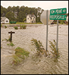
Maryland is experiencing one of the fastest rates of sea level rise in the nation. It also has some of the lowest-lying land, like this part of Dorchester County where Maple Dam Road has been flooded during high tides. Photograph: David Harp
WHEN EUROPEAN SETTLERS PUT DOWN ROOTS around this estuary in the 1600s, many likely didn't recognize how changeable the Chesapeake Bay could be.
They thought that the islands and curving shorelines had always been here, ready to provide an enduring home. But geological evidence tells a different story.
Global warmings and coolings over the millennia have brought the birth and decline of multiple Chesapeake Bays. When temperatures cooled, the great glaciers and ice sheets expanded and sea level fell. When temperatures warmed, the ice melted and sea level rose. As they rose, they drowned the valley of an ancient Susquehanna River, turning it into an estuary. About 10,000 years ago, rapidly rising ocean waters invaded the area near Norfolk and began to fill our current Chesapeake Bay. The rate of rise later slowed, and our estuary took its present shape only 3,000 years ago.
Today, the pace of sea level rise is increasing again. Tide gauges scattered up and down the Mid-Atlantic coast show that water levels here are already rising at the fastest rates seen in thousands of years and among the fastest in the United States. The rise is forecast to accelerate in coming decades. Scientists have documented a variety of causes, many of them driven mainly by human activities like emissions of greenhouse gases by industries and vehicles around the world.
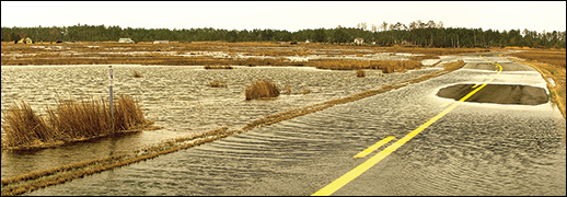
The annual rise in the Bay's waters seems small, about four millimeters a year, and its effects are not very obvious to the occasional visitor. Look carefully, though, and you can see some of them. Woodlands on the lower Eastern Shore have become marshlands dotted with dead white tree trunks, victims of salt water flowing in from the Bay. In other places, the changes are more obvious. Shorelines like those on Maryland's Smith Island and Virginia's Tangier Island are steadily eroding.
The changes are even more conspicuous when big storms blow over. Higher sea level brings taller storm surges and more flooding. In October 2012, Hurricane Sandy pushed five feet of water into Crisfield, Maryland. It was an alarm call warning residents, builders, and government officials around the Bay to prepare for more high water in the future.
Adding to the urgency was a scientific analysis completed in 2013. A team of scientists projected that the sea level around Maryland might rise by 1.4 feet by 2050. Those numbers shoot up to estimates of 3.7 to 5.7 feet by the end of the century. The toll from such a rise would be vast: scientists with the organization Climate Central report that in Maryland alone, more than 55,000 people live in homes less than five feet above the local high-tide line. This zone holds 41,000 homes and $19.6 billion in property value.
To examine these forecasts and their implications in depth, Chesapeake Quarterly teamed up with the Bay Journal newspaper to produce the articles in this special issue of our magazine. Why are the oceans expanding and how high will they go? What are the best scientific explanations? We also looked at the effects on people, on Bayside residents who are seeing firsthand the loss of low-lying land.
The changes touch all of us, including those who don't live right on the Bay. Taxpayers are underwriting flood insurance programs. State and federal officials are planning sea walls and flood walls and changes to roads and other infrastructure — all with the hope of holding back the water.
An overriding, unanswered question: how much land, property, and heritage can be preserved? And at what cost?
— The Editors
About This Special Report
Chesapeake Quarterly is the magazine of Maryland Sea Grant at the University of Maryland. Bay Journal is a newspaper that covers the Chesapeake Bay region. Both publications jointly produced the content, which focuses on how sea level rise presents challenges for the people, communities, and ecology of the Chesapeake Bay region. Staff members from each publication authored separate articles and other material. Content from this report will also appear in print in both publications. For Chesapeake Quarterly, we have organized the articles under the three sections listed below.
The Rising: Why Sea Level Is Increasing
Sea level rise is a global phenomenon, but one that can affect life around the Chesapeake Bay in many different ways. Scientists estimate that this region's rate of sea level rise will accelerate. They have also investigated the causes: ice sheets around the world are melting and land surfaces around the Chesapeake are sinking. What can we expect in the future?
The Costs: Effects on People and the Land
Across the Chesapeake Bay region, diverse communities, both natural and human, are already feeling the toll of sea level rise. Wetlands disappear into the estuary as the water rises. Floods damage homes, businesses, shorelines, and roads. Local residents are looking for outside help and worrying about the future of their communities.
The Response: How People Are Adapting
For those who live in low-lying areas, sea level rise doesn't leave a lot of options: abandon the land or adapt to higher waters. Families deserted Holland Island and Sharps Island and dozens of other islands that now live on only in memories and on old maps. For those who would stay, there are some options: better storm forecasts, better flood preparation, and various old and new forms of flood control engineering.
Copies: You may download a pdf of the print issue of Chesapeake Quarterly in which a selection of these online articles appeared.
Share: Please share this URL for the complete online package: www.chesapeakequarterly.net/sealevel
Donate: Please consider making a financial contribution to support future issues of Chesapeake Quarterly.
Funding: Maryland Sea Grant, which publishes Chesapeake Quarterly, receives funding from the National Oceanic and Atmospheric Administration (NOAA) and the state of Maryland. Maryland Sea Grant is solely responsible for the content in Chesapeake Quarterly.
Listen to the radio interview: Chesapeake Quarterly editor Michael Fincham and Bay Journal writer Rona Kobell discussed sea level rise and these articles on the "Midday on the Bay" program on WYPR public radio in Baltimore with host Dan Rodricks.
|