|
The Perfect Surge: Blowing Baltimore Away
Michael W. Fincham
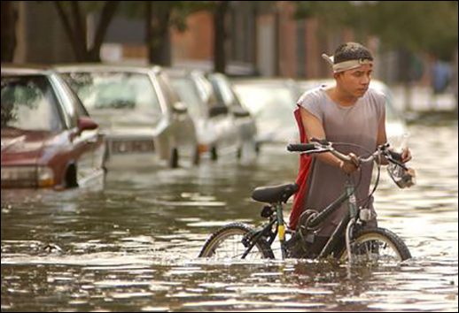
Hurricane Isabel put bikes and cars out of commission when its storm surge flooded Baltimore's Fells Point and Inner Harbor in 2003. Photograph: courtesy of Maximillian Franz/The Daily Record
IT SOUNDED LIKE A JOKE, what could pass for a wisecrack among serious scientists. And this was a roomful of scientists in a serious mood. There were 11 of them and they were trying to figure out how fast and how far the sea level would be rising around the Chesapeake Bay and along the Atlantic coast. The governor of Maryland wanted an updated projection for sea level rise around the state.
The issue at the moment was storm surge. The example was Hurricane Isabel, the storm tide that ran eight feet above normal in 2003, the surge that brought Baltimore its worst flooding in 70 years. The question was, "What can we say about how sea level rise affects storm surge?" This from the group leader, Don Boesch, president of the University of Maryland Center for Environmental Science (UMCES).
The men on the spot were two oceanographers from UMCES: Bill Boicourt and Ming Li, representing the right brain/left brain halves of the science: Boicourt the observationalist who got into oceanography so he can gear up, get out on the water, and collect data, Li the modeler who likes to pull together reams of data so he can build computer simulations of what might be happening in the real world.
The wisecrack came from Boicourt. If the right kind of storm came up the left side of the Bay, if that storm surge was timed just right, if it moved up the Bay in synchrony with a high tide, with a north-moving wave called a seiche, with a north-moving low-pressure zone, and if the sea level — as predicted — were higher, if all those waves are tuned just right, then there could be big flooding in the upper reaches of the Chesapeake Bay. "If it happens to hit it just right — and it could," said Boicourt, "there are calculations where you can blow Baltimore away with the right tuning."
It got a laugh from the room. And this from Boesch: "We're not going to put that in the report." Which got a bigger laugh.
Comedy depends on timing, and tragedy could also, at least in the case of Baltimore. Think of the timing of waves in the Bay as similar to the tuning of musical instruments. Tuning is the process of adjusting an instrument to one pitch, with an orchestra it's the process of adjusting multiple instruments to one instrument, usually the principal first violin.
The best way to blow Baltimore away is not just the perfect storm. It's the perfect storm tide, a tidal bulge that barges up the Bay, keeping time with a strong storm surge and with several other little-known surges, all of them tuned to the same frequency.
To build the perfect storm tide, start with a storm that tracks to the west of the Chesapeake. Like all storms in the Northern Hemisphere, a west-side storm carries counterclockwise winds that will push a surge of water up the mainstem of the Bay. Add to that a high full-moon tide, but think of the tide as a wave, a long wave that crosses the ocean. Each crest may only be two-feet high out in the open ocean, but those high and wide tide crests are hundreds of miles apart from each other. Think of the tidal crest as a bulge of water, a bulge heavy enough to deform the sea floor as it moves across it. The crest moves at high speeds in the deep ocean and as it moves, the sea floor, elastic as a waterbed you just left, rebounds behind it.
As it enters the mouth of the Chesapeake Bay, this long wave feels the bottom, and the friction from a shallow bottom slows it down. Moving north at about 15 knots an hour, the tidal wave takes 11 or 12 hours to move from Norfolk at the mouth of the Bay to Havre de Grace at the head of the Bay.
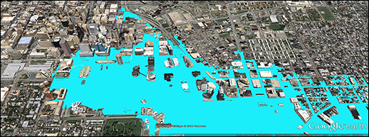
This flooding map above shows areas of Baltimore's Inner Harbor that would submerge during a 100-year storm event. Map overlays such as this are created from FEMA’s National Flood Hazard Layer using Google Earth images. For more information on how to create a map, click on FEMA's mapping web page. Don Boesch (standing) brought together experts from Maryland and the Mid-Atlantic last year to update projects for future sea level rise in the region. Bill Boicourt (far right) explained how a perfect storm surge could threaten Baltimore.
Map: courtesy of Google Earth and the Baltimore Office of Sustainability, photograph: Michael W. Fincham
There's a second kind of bulge that bounces up and down the Bay, but has been little studied in estuaries. Scientists call it a seiche, but Boicourt likes to call it a sloshing. It often starts with the wind blowing water up or down the estuary. The wind from a nor'easter, for example, usually blows water down the Bay, creating a south-moving bulge that flows down past the mouth of the Chesapeake and out to the ocean. That creates a slope in the water surface along the Bay with a low point up north near Baltimore, a midpoint near Norfolk, and a high point, at least in theory, out in the ocean. Water tends to run downhill, both in theory and in fact, so once the wind stops, the water will slosh downhill from that high point, rolling back through the mouth of the Bay headed north toward Baltimore and on to the top of the Bay. Then, like a pendulum, the slosh swings back toward the lower Bay. The natural oscillation period for this back and forth is two days. There's a famous formula behind this estimate.
What if a rotating low-pressure weather system blows north, then south? And what if that two-day oscillation of the low-pressure system matches the two-day natural oscillation of the sloshing cycle? Scientists call that resonance: the effect of the storm and the effect of the slosh will both be magnified. "You are going to get a very efficient transfer of energy," says Boicourt. "And you are going to flood Baltimore."
Let's add another kind of resonance. What if the low-pressure center of the storm is moving up the Bay close to and in sync with the storm surge and with the long wave of a strong incoming tide — that would be an example of a little-studied phenomenon called a Proudman resonance. "If you have low pressure in the atmosphere, that means less air on top of the water," says Boicourt. Less pressure lets a wave grow taller. A low-pressure zone moving in sync with a wave is a rare event, named for the scientist who first identified it, but Boicourt now thinks a Proudman resonance might have been at work during Isabel. It may have helped raise water levels and swell the huge storm tide that flooded downtown Baltimore.
The long wave of the tide, the big slosh of the seiche, the low-pressure Proudman resonance. Add in the storm surge from a major hurricane (and there will be more major hurricanes), get all those waves in tune with each other, like musicians in an orchestra, and you'll amp up the energy of each player. You'll get a symphony that can evacuate downtown Baltimore.
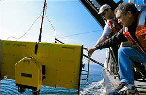
Bill Boicourt and former research assistant Tom Wazniak lower a ScanFish to measure temperature, salinity, dissolved oxygen, chlorophyll and plankton. When the next hurricane approaches, Boicourt and other oceanographers will launch underwater gliders to capture subsurface temperatures, data that could improve predictions for storm surges. Photograph: Michael W. Fincham
Here's another player: the big squeeze. As a bulge from a storm surge, a rebounding slosh and a high tide moves north, the Bay narrows, and so do its major rivers, creating funnels that squeeze water into taller waves aimed at bayside and riverside cities. During Isabel, upper Bay towns like Annapolis and Baltimore ran higher tides than the mouth of the Chesapeake Bay. And upriver towns like Alexandria and Washington, D.C., saw higher water levels than the mouth of the Potomac River. Taller waves are also faster-moving waves. Remember friction, the bottom force that slows a wave down? As a wave grows taller, friction exerts a weaker force on it. Taller waves move faster than shorter waves.
What if you add sea level rise to the music (and there will be more sea level rise)? All those scientists sitting around a room in Annapolis sent a report to the governor projecting a probable sea level rise around Maryland of 2.1 feet by 2050 and nearly 4 feet by 2100.
If their projections prove true then every surge, slosh, and high-tide long wave would be magnified — but in a non-linear way. It's not a case of simple addition, says Ming Li, the oceanographer who's building models to answer questions like this. Consider the effect on storm surge. According to Li's calculations, if sea level rises 2.1 feet, you add an additional 20 percent to get the actual increase — 2.5 feet — in the size of the storm surge. The 8.3-foot storm tide from the last Isabel grows to a 10.8 foot, a one-story tide that could swamp Fells Point (again), flood the Inner Harbor, and invade parts of the downtown business district.
But the surge from the next Isabel could be larger still. What if the surge from the next Isabel is moving in sync with the long wave and the big slosh and perhaps the rare, low-pressure Proudman effect? As the Bay narrows, the surge grows taller, friction grows smaller, the surge moves faster. And one big bullseye would be Baltimore.
That's a lot of what-ifs that have to hit. "The chances of all those forces combining in sync are perhaps not high" says Boicourt. For most storm surges in most years, you won't get all those players in tune.
But there will be some opportunities for the whole orchestra to play together. Future hurricanes may not be more frequent, but they will probably be more ferocious, say most experts. They will pack more energy, unleash stronger winds, and push higher water levels into the city. Perhaps Isabel was only the overture.
Baltimore might want to move Camden Yards up on Federal Hill.
|