|
More Information on Sea Level Rise
Bay Journal, 2015
Studying the Causes of Sea Level Rise and Projected Increases
Planning for Sea Level Rise
- CoastSmart Communities, Maryland Department of Natural Resources, http://dnr.maryland.gov/CoastSmart/resourcecenter.asp — This state program works to help homeowners and coastal communities plan for coastal flooding and sea level rise. The website includes, for example, a fact sheet about elevating houses to avoid flooding and lower flood insurance premiums.
- Climate Change in Maryland, Maryland Department of Natural Resources, http://www.dnr.state.md.us/climatechange/ — Learn about other ways that the state of Maryland is working to adapt to the effects of sea level rise and other aspects of climate change. Provides links to tips on how people can help in their everyday lives, like conserving electricity and water.
Floodplain Maps and Federal Flood Insurance
- Maryland Digital Flood Insurance Rate Maps (DFIRM), http://mdfloodmaps.com — Coastal flooding, which is worsened by sea level rise, has led the federal government to update floodplain maps in Maryland and other states. The redrawn maps have included some homeowners within floodplains who previously were outside -- and as a result, may be required to purchase flood insurance for the first time. However, property owners may be eligible to save money on premiums through the National Flood Insurance Program if they obtain policies through the program before new floodplain maps take effect. This website has an online tool that allows users to understand their flood risk and choices.
Sea Level Rise Viewers
Several websites allow users to see for themselves the simulated effects of differing amounts of sea level rise at the neighborhood level around the Chesapeake Bay. Here are some of these viewers and their features:
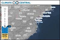
- Climate Central: Surging Seas, http://sealevel.climatecentral.org/ssrf/maryland — Pick a level of sea level rise (up to 10 feet), and you can see the numbers of people, houses, and acres in towns and cities that would be inundated. This viewer also plots the locations of schools and hospitals; identifies the income and ethnic makeup of people in the areas affected; and shows ranges of property value (by acre), among other information.
- Sea Level Rise and Coastal Flooding Impacts Viewer, National Oceanic and Atmospheric Administration, http://coast.noaa.gov/digitalcoast/tools/slr — See photos of various landmarks as they would look under higher water. The simulation illustrates the loss of marshes as they are flooded.
- Coastal Atlas, Maryland Department of Natural Resources, http://dnr.maryland.gov/ccs/coastalatlas/ shorelines.asp — This site provides multiple layers of information about coastal hazards suitable for planning purposes. These include 100-year flood plains and areas suitable for building living shorelines to reduce erosion.
|
Contents
October 2014
vol. 13, no. 2 & 3
The Rising: Why Sea Level Is Increasing
The Costs: Effects on People and the Land
The Response: How People Are Adapting
5825 University Research Court
Suite 1350
College Park, MD 20740
|
