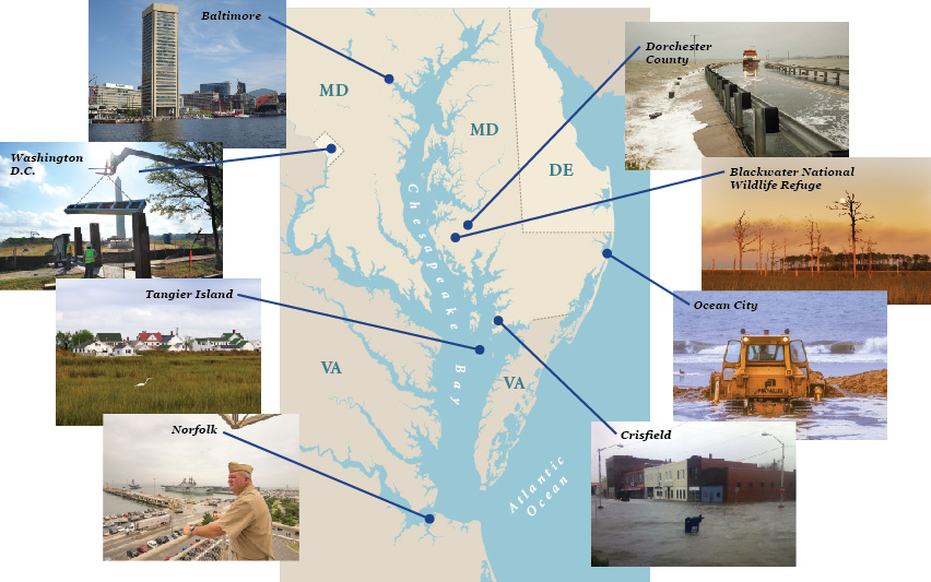
A special report by Chesapeake Quarterly and Bay Journal
Comment on this article
ARTICLES | VIDEOS | PHOTOS | MAPS


Chesapeake Quarterly is the magazine of Maryland Sea Grant at the University of Maryland. Maryland Sea Grant receives funding from the National Oceanic and Atmospheric Administration and the state of Maryland. Bay Journal is a newspaper that covers the Chesapeake Bay region. Both publications jointly produced the content in this special report about how sea level rise presents challenges for the people, communities, and ecology of the Bay region. Staff members from each publication authored separate articles and other material. Content from this report also will appear in print in both publications.


Videos: Residents Talk of Rising Waters

Casey Todd

Holland Island Memories

Casey Todd's father was the last man born on Holland's Island so Todd grew up in Crisfield hearing the stories of life on an island that once held 70 homes, a school, a church, and more than 360 souls before most of the island disappeared beneath the Chesapeake Bay.
Johnny Schockley

Hooper's Island Now

Hooper's Island is a chain of three islands, only two of which are connected by bridges today. Jay Newcomb and Johnny Schockley talk about the high water they've seen over the years.
John Barnette

A Crisfield Flood

The storm surge from Superstorm Sandy flooded out more than 300 homes in Crisfield. Some sought shelter, rescued by a number of first responders, including the Maryland National Guard and the Somerset County Swift Water Rescue Team, led by waterman John Barnette.


The Water's Steady Advance


Chesapeake Bay: Waters Rising

Click on the location to read an article about that area.


Explore Map The Perfect Surge: Blowing Baltimore Away The Future of Blackwater Snapshots from the Edge Norfolk: The Navy on the Leading Edge When Sandy Came to Crisfield Norfolk: The Navy on the Leading Edge Early Warnings from Smith and Tangier Islands If Katrina Came to Washington


Will Your Neighborhood Flood?

Click on "VIEW THE FULL SIZE MAP" to explore by town or zip code.


Have You Been Affected by Floods, Storms, or Erosion?

Tell us your story.

* Disclaimer

By submitting your story to Chesapeake Quarterly, you agree to let Chesapeake Quarterly publish your story in whole or in part, with your name on chesapeakequarterly.net, without further permission, notice, or compensation.

About the Opening Photo

Last house on Holland Island. Credit: David Harp

This was the last house on Holland Island in the Chesapeake Bay. It stood for more than a century, one of about 70 homes on the island, where some 360 people once lived. But as the estuary's water level rose, the island eroded, and by 1918 all of the inhabitants left. By early in the 21st century, only this house remained, surrounded by water at every high tide. Its last owner, the Rev. Stephen White, a Methodist minister, spent thousands of dollars from his own pocket trying to save the house by building up the shoreline around it with sandbags and other materials. But in October 2010, the house was swept into the Bay by encroaching waves.

Photographer David Harp took this shot in May 2009. He held his camera low to the water's surface to capture the effect shown. "I remember photographing there years before when there was a lawn there," he recalls. "I played softball on that lawn. There was ample space to play, not far from the house." Harp took the photo while standing in the same spot where he had played ball — except "I was in water up to my knees."

For more about the photographer, visit David Harp's website. For more about Holland Island, watch this Chesapeake Quarterly video.

       
Maryland Sea Grant | 5824 University Reasearch Court, Suite 1350 | College Park, MD 20740 | Phone: (301) 405-7500 | Fax: (301) 314-5780