|
A Flood Wall against the Future:
If Katrina Came to Washington
Michael W. Fincham
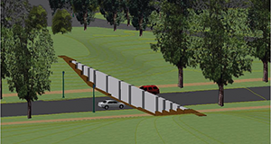
Engineers test out a new, removable flood wall designed to protect downtown Washington, D.C., from waters unleashed by a once-in-a-100-year storm event. The post-and-panel structure will go up on 17th Street whenever a major flood threatens and come down when the threat subsides. Photograph: Michael W. Fincham
RUSH-HOUR COMMUTERS COME BARRELING into Washington D.C. every workday, but on Halloween morning in 2014 they got an unwanted surprise: they found one of their most popular routes blocked off by yellow police tape.
It seemed an odd place for a crime scene investigation. The 17th Street shortcut across the National Mall is popular because it offers a scenic gateway into the city center, cutting between the towering Washington Monument and the Lincoln Memorial with its long, sky-colored reflecting pool.
This shortcut had once been a crime scene of sorts back on a stormy St. Patrick's Day in 1936 when the Potomac River staged a major breaking-and-entering episode, shoving floodwaters into the city through this same roadway.
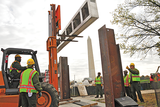
What commuters could see behind the yellow tape this Halloween morning was not a crime scene, but a work scene. Three forklifts shuttled back and forth unloading two flatbed trucks stacked with bright aluminum panels and rust-colored steel posts, the metal pieces for an odd new monument for the Mall. Call it a crime prevention scene: three dozen workers in hard hats and neon-green vests were trying to set up a flood wall that, in theory, would block off this gateway and guard the city from future break-ins by the nearby Potomac.
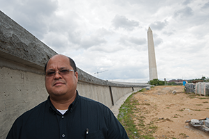
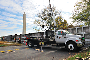
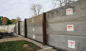
Rolando Sanidad, project manager for the U.S. Army Corps of Engineers (top), stands by the east stone wall, one of two permanent pieces of the flood wall to block off 17th Street during major flood events. The removable panels of the flood wall connect to the west stone wall on the other side of the street. With posts and panels finally in place, the removable flood wall puts a nine-foot barrier between downtown D.C. and the Potomac River (bottom). Photographs: Michael W. Fincham
When Hurricane Katrina overwhelmed New Orleans in 2005, that crisis raised alarms in coastal and riverside cities around the country, including Washington, D.C. That hurricane sent a storm surge toward New Orleans that broke through weak points in an elaborate but ancient levee system, letting rivers of seawater pour through the gaps and inundate streets and neighborhoods, homes and businesses. The result was a civic catastrophe — and a signal. According to recent forecasts for global warming, the future will bring rising sea levels, more ferocious storms, and stronger storm surges, a trifecta that carries expensive penalties for poorly prepared communities. Downtown Washington, D.C. under some scenarios is vulnerable to major flooding from the tidal waters of the Potomac River.
With Katrina invading New Orleans and Sandy surging into New York City in 2012, American planners are now looking more seriously at engineering solutions that once seemed too far-fetched, too expensive, too European. The British now have floodgates across the Thames River in hopes of protecting London. And the Dutch spent several decades building the massive Deltaworks project, a series of dams, dykes, locks, and levees that stretched across the mouths of several estuaries in the Netherlands. On this side of the Atlantic, planners in New York are now discussing the idea of building a surge barrier across the Hudson River at the Verrazano Narrows. And in Virginia, scientists recently began running computer modeling studies to test the pros and cons of building a giant floodgate across the mouth of Chesapeake Bay.
Along the banks of the tidal Potomac, planning agencies took one clear lesson from Katrina: look to your levees. Most visitors to Washington D.C. — and most natives — don't know the National Mall already has a flood-control levee, a low-lying, park-like ridge that was built along the north flank of the Lincoln Memorial Reflecting Pool. It was supposed to connect to the high ground near the Washington Monument. Those who do know about the levee also know that it has a major gap: that busy 17th Street shortcut across the Mall.
To plug this historic gap, the U.S. Army Corps of Engineers designed a moveable flood wall that could go up before the floodwaters arrived and come down once they subsided. That was the theory, and testing that theory was the goal that gathered all those trucks and forklifts and people on the Mall early on Halloween morning. Most of the workers came from the National Park Service, the agency that would take control of the wall and carry responsibility for erecting it well in advance of any future floods.
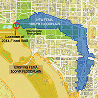
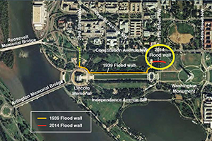
FEMA's new floodplain map (above left) led to the decision to build the flood wall. Finished in 2014, the wall closes a gap in the flood control levee built in 1939 (orange line, map above right). The old plan to fill the gap with sandbags was deemed inadequate after Hurricane Katrina. Maps: National Capital Planning Commission
"The Park Service is going to have to do this install every year," said Rolando Sanidad, the project manager for the Corps and the man responsible for getting all the posts and panels and people together at the right place and the right time. "That's why you see such a heavy Park Service presence today," he said sweeping his arm toward all those workers in neon-green jackets. "They are actually doing hands-on training getting this stuff installed."
Some slightly nervous engineers were also doing eyes-on monitoring, checking the schematics on their clipboards as forklifts began swinging the posts and panels off the trucks. The new flood wall would have to be assembled from 35 very heavy pieces of metal. The eight metal posts weighed in at 1,200 pounds each. And the 27 aluminum panels tipped the scales at 800 pounds each.
All those posts and panels were numbered and lettered so they could be hooked up in the right order and in the right place. Think of putting together Ikea's largest wall cabinet or the world's largest Lego toy — then amplify the process by several orders of magnitude. Heavy manhole covers had to be lifted off the roadway, long metal posts had to be plugged into the manholes, aluminum panels had to be slotted in between the posts.
"During a normal operation, what we'll do is come in and put in all the posts, working from the east side to the west," said Sanidad, pointing to workers carefully lining a post above a manhole. Each post had to drop into a slot in a steel beam buried beneath the street. That beam in turn was sitting atop three concrete pillars that reach 30 feet down to connect with the ancient bedrock below the Mall. Each of these unseen pillars is embedded in a five-foot socket drilled into rock.
With the posts in place, the forklifts motored up, swinging heavy panels high in the air. With some yelling and a lot of back-and-forth maneuvering by the forklifts, workers lined up the panels and slid each one slowly down between two slotted posts. The bottom panels sat atop rubber gaskets, creating a tight seal with the street. Atop each bottom panel sat two other panels. The end result was supposed to be a metal wall nearly nine feet high stretching across the old 17th Street roadway gap.
The metal barrier also had to connect with two new concrete walls: one on the east side of the street, one on the west. Curving gracefully out of the nearby high ground, each wall ends abruptly in mid-air, looking like some kind of a misplaced ski jump. Clad with gray stone typical of many federal monuments, the stone walls connect the metal street-level wall with the high ground, tying this whole exotic structure into the familiar landscape of the National Mall.
Once the crew got the flood wall up, their job would be halfway finished. This Halloween event was only a test run for a future crisis, so the crew would have to take the wall apart and clear the street.
Even if this test went well, there would be other test runs, annual practice sessions to keep Park Service crews trained and ready. Perhaps some nighttime training, said Tony Vidal, chief engineer for the project for the Corps. "It's probably a good time to install it in the middle of the night," Vidal said, "because floods always happen right in the middle of the night, when you can't see, and it's cold and wet."
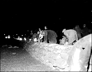
How was the 17th Street gap closed during past floods? "Sandbags," said Amy Tarce of the National Capital Planning Commission. "If you google 'floods in D.C.,' you'll see historic photos of people in the middle of the night stacking sandbags." They were the solution du jour during three great floods of the 20th century: 1936, 1942, and 1972.
An artist’s sketch shows an early version of the 17th-Street flood wall (top). The photo below shows the “post-and-panel” flood wall with labeled panels in place during the test assembly on Halloween 2014. The Washington wall has nine posts and 27 panels, all of them stored off-site. When a major flood event threatens the city, they will be trucked to 17th Street and craned into place. Drawing: courtesy of the U.S. Army Corps of Engineers; photograph: Michael W. Fincham
It was that "St. Patrick's Day Flood" of 1936 that gave birth to the idea of a levee along the National Mall. Also known as "The Great Spring Flood," this historic event not only inundated low-lying sections of the city, it also inspired Congress to order the Corps of Engineers into action. The engineers quickly built a new levee, a concrete wall that ran ruler-straight from the high ground of the Lincoln Memorial toward the higher ground of the Washington Monument. The engineers finished the wall by 1939, and in later years tore parts of it down and replaced it with the long, grassy embankment that now flanks the Reflecting Pool. According to Vidal, parts of the old wall are buried under the grass. The gap at 17th Street, however, was left as a permanent roadway, a breach to be sandbagged during flood times.
It was Katrina that killed off the sandbag solution. After the failures in New Orleans, the Federal Emergency Administration (FEMA) ordered the Corps to re-evaluate levees around the country, and the National Mall levee got a failing grade. There was that large gap at 17th Street and a low point at 23rd Street near the Lincoln Memorial. Sandbags would no longer suffice: they could topple during a big storm.
The gap at 17th Street, during a once-in-a-100-year storm, would let floodwaters from the Potomac surge up the road, take a right turn just past the Washington Monument and flow east down Constitution Avenue, spreading out to swamp an impressive list of federal buildings. At risk under various high-water scenarios would be the Justice Department, the Commerce Department, the IRS headquarters, the Smithsonian's Museums of Natural History and American History, the National Archives, even the National Gallery of Art. River waters could also pour down vents and stairs and escalators to disable the city's subway system. The city needed a better stopgap than sandbags.
When the Corps failed the levee, FEMA unleashed a storm of its own. It drew up a new map for the 100-year floodplain, labeling many dry land areas as floodable areas and automatically raising the threat of higher insurance rates under the rules of the National Flood Insurance Program. "There was a big uproar from the District," said Tarce at the National Capital Planning Commission. FEMA then exacted a promise that the city would fix the levees by November 2009.
Workmen from the Works Progress Administration (WPA) use sandbags to build an emergency levee against the Great Spring Flood of 1936 in Washington, D.C., the event that led Congress to order the building of a permanent levee along the National Mall. Photograph: Department of the Interior
It would, however, take six years to fix a levee that was originally built in two. Five options for the wall were designed and debated, and all of them had to work their way through 11 city and federal departments, including agencies as diverse as the U.S. Commission on Fine Arts and the D.C. Historic Preservation Office. More delays ensued when the principal contractor had to be fired, and another had to be hired. According to Vidal, "The only thing that really got this thing finally built, I hate to say, was Katrina."
There's a lesson there about the problem of flood control in Washington, D.C., said one engineer. When many agencies are in charge, no one is in charge.
Another lesson: Washington's new stopgap wall, when finally in place on 17th Street, cannot be a final solution to flood risks facing the nation's capital. That lesson comes from Gerry Galloway, a research engineer from the University of Maryland who collaborated on studies of Hurricanes Katrina and Sandy.
A nine-foot flood wall designed for a 100-year storm may not be enough to hold back future floods. According to Galloway, Washington, D.C., could be walloped by a one-two punch: rain-storm floodwaters rushing downriver out of the Potomac watershed and a hurricane storm surge driving upriver on a high tide from the Chesapeake Bay. The result could be a 500-year flood that would turn Constitution Avenue into a river running 10 to 12 feet deep. An even larger storm could do worse. "A Category 4 storm being pushed up the river at a time when the river is high would be a disaster," said Galloway. According to his calculations, flood levels would run 16 feet along the avenue.
High waters could also be coming from bizarre storms, odd events that don't fit our conventional definitions, said Ed Link, a senior research engineer at the University of Maryland who said he used to work for the Corps as "chief geek" or director of research. "We have these stereotypical conceptualizations of storms," said Link. "They are based on homogenous databases of hurricanes and river storms and nor'easters." But not all storms fit these categories. "Sandy was an aberration," he said. "It was this hybrid, it didn't behave like a hurricane, it didn't behave like a nor'easter, it behaved like a monster."
That leads to another, even more sobering lesson. There's a gap that may never be closed: the gap between our hopes to control flood risks and our limited abilities to predict them. How do we forecast these hybrid monsters? And how do we plan for them, especially in an era of rising sea levels. "Statistically we are in Never-Never Land," said Link. "We don't have good statistics for those kinds of weird things — and those weird things are the ones that cause the most problems."
You see the dilemma: does a city like Washington protect itself against the storm we think we can predict, the 100-year, or the 500-year event? Or does it plan something more ambitious, an engineering solution that protects against the weird monster that may never arrive?
It's sort of an existential dilemma for planning officials all along the Mid-Atlantic, whether they are debating a flood wall for Washington, D.C., a giant surge barrier across the harbor of New York, a giant barrier across the mouth of the Chesapeake Bay, or seawalls for small endangered islands like Smith and Tangier that are now slowly dwindling away in the middle of the Chesapeake.
Prepare for the predictable or for the nightmare monster? "I'll give you what my Dutch friends say," said Galloway. "It is much better for us as a nation to prepare for the totally giant event than it is to try and recover in our country from a flood." The United States, of course, is not the Netherlands, where the government has built dams and dikes and barriers across the mouths of several estuaries and is already preparing for rising sea levels by budgeting additions and repairs that stretch nearly two hundred years into the future. In the Netherlands, a giant storm surge out of the North Sea could inundate half the country. "They say they cannot afford to let it happen," said Galloway.
The key question in planning for flood control: "What is the risk you are willing to accept?" How do you answer that for Washington, D.C., where the threat is to symbolic structures rather than national survival? "In the iconic capital of the most powerful nation in the world," asks Galloway, "do we want to have a picture of downtown Washington underwater?"
How does a city prepare for a disaster it can't define simply or predict accurately? How does a state? A country? By a planning approach that recognizes the limits of planning. By predictions that recognize the limits of predictions. Those paradoxes lie at the heart of what Link and Galloway are preaching as a result of their analyses of Katrina and Sandy and other great flood disasters. "I need to be worried about these uncertainties," said Link, "about these things that I don't know I don't know." Flood control engineers talk like philosophers because they don't want to look like generals who keep preparing to fight the last war rather than the next one.
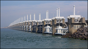
The disastrous North Sea Flood of 1953 spurred the government of the Netherlands to start work on the Deltaworks Project, a series of dams, dikes, sluices, locks, and levees to protect against another catastrophic storm surge. The Oosterscheldekering storm surge barrier (shown above) is the largest structure in the system, stretching nine kilometers and including sluice gates that are only closed during flood threats. Photograph: Vladimir Šiman
The answer, said Link, is to apply certain key principles, and one of them is ongoing adaptation. "Everything has to be built to allow additional options," said Link. "Every time you take steps one and two, you are anticipating needing to take steps three and four." You may not know yet what those next steps would be, but "you make sure that step two isn't the last thing you can do."
A taller flood wall at 17th Street, for example, shouldn't be the last step in protecting Washington. "I am not suggesting that we need a 20-foot wall or a 30-foot wall surrounding downtown Washington," said Galloway. He points to other options. Structures in the flood zone could be individually prepped: subway vents can be shielded, generators and electrical boxes can be moved to the upper floors of buildings. "You might have mud," he said, "but you can still operate the buildings a day and a half later. It's flood-risk reduction, not flood prevention." Prepping infrastructure and training staff could reduce the impact of large, poorly predicted flood events.
Well before noon, the wall was up, and Washington, D.C. had a nine-foot barrier in place if Katrina came surging up the Potomac. The engineers checked out all the joints and fittings and slots. The work crew gathered in front of the wall for photographs "This is a historic day for the city," said a Park Service engineer. "The water can come," said Sanidad with a smile.
Then everybody went back to work. This Halloween event was only a test run for a future crisis, so the crew began taking the wall apart to clear the street. No flood was coming today, but the afternoon rush hour was, and it was only hours away.
The workers craned all the posts and panels back onto the trucks and slid the clanging manholes back into place. By mid-afternoon the yellow tape was down, the tractor-trailers were rumbling away, and the Washington flood wall was headed back to storage.
Test runs and training could be the key to flood control for the Nation's capital. Otherwise that moveable wall and all its moveable pieces could sit in storage for years, even decades, waiting for the next great spring flood or hurricane storm surge or hybrid storm event.
When one of those monsters arrives, police cars with whirling red and blue flashers will pull up, officers will string their yellow tape, the National Park Service will haul the wall out of storage, the big trucks will rumble down Constitution Avenue, the forklifts and cranes will swing into action again.
And some people will hold their breath. "There's Murphy's Law to worry about," said Galloway. Some cities have misplaced their flood barriers, he explained. Others have not gotten them up in time. Let's hope the guys who know where the pieces are stored are not on leave and the guys who remember how the pieces go together are not retired.
The new flood barrier is essential, but it may not be enough. "We've been lulled into this false sense of security that if you have a 100-year flood protection, then okay, we're safe," said Galloway. "The Dutch just laugh at us when we say that."
|