|
The Storm over Surges:
When Sandy Came to Crisfield
Michael W. Fincham
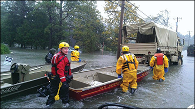
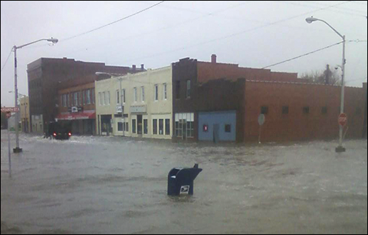
John Barnette (red jacket) leads the Somerset County Swift Water Rescue Team into the flooded streets of Crisfield during Superstorm Sandy in 2012. Working with a small jon boat and the big trucks of the Maryland National Guard, the team brought out residents trapped by the floods unleashed by the storm surge. Photographs: Crisfield, courtesy of Salisbury News, sbynews.com; Rescue team: courtesy of the Somerset County Swift Water Rescue Team
EVERY SEPTEMBER JOHN BARNETTE starts lifting all his crab traps out of the wide lower reaches of the Wicomico River. He motors up to a series of wire cages designed to catch summertime peeler crabs. Each cage is tall enough to stick up out of the water, and raising them out of the river, an annual autumn ritual, is hard work, best done when the temperatures are cooling and the Chesapeake Bay is beginning to turn clear and the blue crabs are heading south. The white haze of summer is gone and so are most of the late-day thunderstorms, but in 2012 he was keeping close track of weather forecasts. Autumn can bring large, late-season storms to the Chesapeake.
A waterman all his working life, Barnette is a lean man in his mid 50s, who has close-cropped hair, a strong jawline, and strong opinions about water safety. When he's not catching peeler crabs and working his oyster leases, Barnette heads up his county's Swift Water Rescue Team, a group of volunteers who try to save people from drowning, especially during storms and floods. One of his opinions is that even a small hurricane could easily submerge the lower third of his home county. Another is that sea level is rising and hurricanes may soon do even more damage around here. A largely flat, somewhat marshy slice of Maryland's lower Eastern Shore, Somerset County is bracketed by water on three sides: the Wicomico River on the north, the Pocomoke on the south, and the Chesapeake Bay on the west. Nine years earlier, he saw waters rise six feet on a Tropical Storm Isabel storm tide and submerge much of Dorchester County just north of here.
At each of his traps, Barnette has to winch an empty cage up onto his small boat and begin dismantling the nets and the net poles that run between the cage and the riverbank. Shouldering the poles, he slogs back into the marshes where he stands his poles up and leans them together. As he glides away from each site, he can see the tops of his net poles sticking up out of the tall marshes like tentless teepees.
By October, Barnette was dredging oysters and checking in with members of his rescue team. A tropical depression in the Caribbean was turning into a tropical storm named Sandy. By the time it hit Jamaica, Sandy was a Category 1 hurricane, by the time it hit Cuba and Haiti, it was a Category 2. As it moved north up the Atlantic coast, NOAA meteorologists tried to define the structure of the storm: Was it a hurricane? A tropical storm? A post-tropical depression? A wintertime low-pressure area? Or perhaps all of the above.
By the time Sandy reached the Chesapeake region, Barnette and his rescue team had reason to relax. The storm was running north along the ocean side, staying well east of the Chesapeake Bay, a track that usually drives water out of the Bay. The Eastern Shore, it seemed, faced little threat from a storm surge.
Sandy, of course, quickly became famous as a superstorm when it moved ashore up north in New Jersey. On October 29, it began pushing a historic storm surge through the state's seashore towns and pouring water into the streets and subways and suburbs of New York City. Down south in tiny Mount Vernon, Maryland, an unexpected phone call came in to the volunteer fire department. Could Barnette bring his Swift Water Rescue Team down to Crisfield, Maryland? "We've got people who need to be rescued," said the caller. "We've got flooding like we've never seen before."
It's not been the best of times for scientists trying to predict the worst of times. Around the Chesapeake Bay the worst of times are usually brought on by hurricanes, tropical storms, and nor'easters. They bring high winds, power outages, and flooding — much of it from storm surges and storm tides, both of which will come in stronger and higher as a result of rising sea level. Over the last 20 years, scientists with the National Weather Service (NWS) have sharpened their predictions for hurricane tracks but they have not made as much progress on their forecasts for hurricane intensity, says John Billet, science officer for the NWS Wakefield office. For storm surges, a spinoff of storm intensity, their forecast models have missed the mark during three recent hurricanes: Isabel in 2003, Irene in 2011, and Sandy in 2012.
What's missing from their models? To predict the risk and reach of hurricane storm surges, research scientists test out various experimental models and federal forecasters run operational models, dozens of models every day, using supercomputers to crunch data — a lot of data. The numbers come from buoys and balloons and aircraft, from ships and satellites, and they record air pressure, wind fields, wave actions, tidal levels, and temperature swings in both the atmosphere and the ocean. Stuffed with data and interlaced with equations, the models are supposed to suggest where storm surges will hit and how bad the flooding will be.
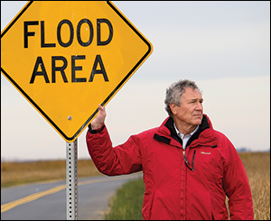
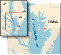
Better forecasts for hurricane storm intensity is the focus for Bill Boicourt, an oceanographer with the University of Maryland Center for Environmental Science. Photograph: David Harp; map: iStockphoto.com/ University of Texas Map Library
The results, however, have been uneven. In their post-storm review, the National Weather Service found that the storm surge from Isabel in 2003 ran one to three feet higher in the Chesapeake than NWS predicted, especially in the northern Bay. Its forecasts for Irene and Sandy were off even more. They overpredicted the surge for Irene, and for Sandy they underpredicted how much water would sweep into Crisfield.
The science community learned a lot from those storms, says Bill Boicourt, a physical oceanographer with the University of Maryland Center for Environmental Science who works closely with forecasters with the National Weather Service. "That's another way of saying we blew the forecasts."
Predictions about storm surges in the Chesapeake usually begin with some basic physics about hurricanes and some basic geography about the Bay: hurricanes are tropical cyclones, large low-pressure systems that spin with a counterclockwise rotation, creating high winds and carrying heavy rains; the Bay is a long, narrow line of water running north and south. Hurricanes moving up along the east side of the Chesapeake usually drive water southwards down the Bay. Storms moving along the west side drive water northwards up the Bay. West-side hurricanes are much less frequent than east-side storms, but they do much more damage. As the Bay narrows to the north, it creates a natural funnel that squeezes incoming storm surges, raises water levels and expands the reach of surge-related flooding. The same funnels are found in each major river. During Isabel, water levels in Washington, D.C., were higher than they were at the mouth of the Potomac River.
"Isabel was a surprise," says Boicourt, in part because it was the first major storm in decades that tracked to the west of the Bay. It arrived in 2003, 70 years after the great August Hurricane of 1933, and it nearly matched the damage done by this legendary storm of the century. The 1933 hurricane entered the Chesapeake during the high point of a strong high tide, a collusion that helped create huge storm tides and surges and extensive flooding. Isabel, however, entered the Bay region on a much weaker high tide, but it still managed to hit many of the high-water marks from 1933. Sea level, as measured at Hampton Roads, had risen 1.35 feet in the region in 70 years. Isabel's storm surge flooded large tracts of Maryland's Eastern Shore and drove waist-high water into the downtown streets of Annapolis, Baltimore, Alexandria, and Washington, D.C.
Both Irene in 2011 and Sandy in 2012, on the other hand, were east-side storms. That's usually a less damaging storm pattern, but forecasts for their storm surges also proved problematic. The storm surge height during Irene fell 50 percent below model predictions, says Boicourt — but the storm surge during Sandy swept in at 15 percent above predictions. Storms passing to the east usually drive water down the Bay, and Sandy seemed no exception — at first. As Sandy passed by Maryland, water levels began dropping in Baltimore and Annapolis and along the western shore of the Bay. But unexpectedly they began rising along the lower Eastern Shore, especially in Crisfield.
It was an embarrassing moment for forecasters. The National Weather Service was predicting a two-to-four-foot surge for the lower Chesapeake but a five-foot surge was rolling into Crisfield. "We didn't expect that much to come across [the Bay]," says Billet, the NWS meteorologist. As the storm approached, Boicourt, the academic oceanographer, was getting questions about possible flooding. "I told people not to worry about Sandy," says Boicourt. "I was wrong."
John Barnette was not feeling well prepared about Crisfield. When the call for help came in, he met up with three team members of the Swift Water Rescue Team down at the Mount Vernon Fire Department. They hooked the 15-foot jon boat to the back of the big Chevrolet SUV and set off under low, wet clouds for the windy 25-mile drive down rain-slick roads.
His team, in his opinion, was well trained but poorly equipped. He'd run regular practice sessions during the year and had his team work with the University of Maryland Fire and Rescue Institute. It was that little flat-bottomed jon boat that bugged Barnette. Some inflatable Zodiacs, big, buoyant, and better balanced would be helpful. When a county official, nervous about the approach of Sandy, asked what gear he needed, Barnette told him, "It's too late, we can't go to Walmart and get it."
"Sandy was a watershed event," says crabber and oysterman John Barnette, who headed up the Somerset County rescue team that responded to the flooding of Crisfield in 2012. Photograph: Michael W. Fincham
Driving into Crisfield, his team saw trees down, power lines down, a cemetery buried in gray water, its white gravestones sticking up in the flood like soldiers standing at attention. Water in the streets: ankle deep in places, knee deep, waist deep. Cars with water over their hoods, homes turned into islands. They found other rescue teams already working the flood: one group drove all night from South Carolina, hauling Zodiacs and a trailer full of extra equipment; the state police and the marine police were there, and the Maryland National Guard had rumbled into town with Humvees and trucks, most of them big, five-tonners. A city official gave Barnette and his team a list of names and addresses, people to be rescued. The list was two pages long.
Barnette drove into the flood as far he could, then launched the jon boat and tied it behind a big five-ton National Guard truck. Wading down Somerset Avenue, Barnette and his team began working the list, sloshing up to doorways and porches, loading people into the boat and ferrying them two at a time back to the Guard's big truck. With a Zodiac, Barnette thought, they could be ferrying six adults each run. When the rising water reached the truck's exhaust pipe, the driver put on the brakes, turning the big brown truck into another island in the stream. The rescue team kept wading through the streets in their bright yellow rain suits, ferrying people through the darkening water as the wet gray light began to wane.
Six months after Sandy, the question came politely to Bill Boicourt: "Am I right in saying that the models for Superstorm Sandy in the Chesapeake failed to predict the inundation of Crisfield?"
The occasion was a day-long conference. Eleven scientists from five states were camped around a quadrangle of long tables, settled behind their laptops, trying to come up with new projections for future sea level rise. There were PowerPoint presentations, and catered lunches, and for the oceanographers in the room, there were those questions about Crisfield. With sea level rising, accuracy in storm-surge forecasting was going to become even more critical in the near future.
The answer also came politely. "I'm going to be very careful about this," said Boicourt. In the days after Sandy had finished with Crisfield, he had gone back through the data and the storm surge models. With water levels dropping on the western shore, why did a five-foot storm surge roll east through Crisfield? It's an important question in an era of rising sea level: this historic fishing town, once the second largest city in Maryland, sits at the narrow end of a skinny peninsula surrounded by water on three sides. With many of its streets sitting less than three feet above current sea level, the place barely sticks above the waters of the Bay.
In his search through the storm data, Boicourt found what he was looking for: an explanation for an unexpected eastward surge of water. The prime mover, Boicourt said, was "the wrap-around wind" from Sandy. When the eye of the storm moved ashore in New Jersey, the size of its rotating cyclone was so large that the winds circling along its outer rim reached south all the way down to Maryland. In the western end of the state, those winds met a winter storm from the Midwest and started a blizzard, dropping two feet of snow in the mountains of Western Maryland.
Farther east, the bottom curve of Sandy's cyclone sent winds blowing out of the northwest and straight down the long reach of the Potomac River. Those winds pushed water out of the river, shoving it eastward across the Bay toward Crisfield.
The result, said Boicourt, was a "cross-bay setup," a slope in water levels with the high side on the eastern side of the Bay. This kind of setup was unusual, but it was probably not a one-time event. When Boicourt went further back, looking at the data and models for Hurricane Irene, a much smaller, east-side storm that hit a year earlier, he got another surprise: "Sure enough," he says, "there was a bulge on the eastern side of the Bay for that hurricane also." A small bulge that was easy to overlook — for a small storm.
It sounds like a simple answer, almost too simple: wind drove the surge across the Bay. But getting good data on wind energy, understanding its effect on water energy, and getting the data into models are not simple tasks. "We don't know how to translate accurately the wind-as-measured-over-water into actual stress delivered to the wavy surface," said Boicourt. "That's still a fuzzy thing."
Working the flooded streets of Crisfield in the fading light, John Barnette watched a National Guard truck back up and impale itself atop a fire hydrant hidden below the floodwaters. The broken hydrant began draining the town water supply, the Guard began sending other trucks to offload the evacuees from the truck, and Barnette kept his rescue team working. They turned the static, stuck truck into another island, a relay station where they could bring evacuees to wait under cover for the next pickup.
With winds gusting to 90 miles per hour, with trees still falling, with the light finally gone, all the teams were called in by 7:30. Barnette's group, by his estimate, brought out almost 40 people. More than 200 people had been carried out in all. They were trucked to a Red Cross shelter 20 miles up the road in Princess Anne. By the end of the day the shelter held 500 people, most of them driven out of their homes by power outages and by a storm surge that ran stronger than anyone expected.
Were there lessons from Sandy? When predictive models fall short in their forecasts about storm intensity, communities like Crisfield have to scramble to find help and evacuate people. And scientists have to scramble to answer questions. What data were missing from their models?
Nearly two years after Sandy, Bill Boicourt was trying to line up small boats during the summer of 2014, hoping for some hurricane action along the Mid-Atlantic. He wanted to measure water temperatures in the ocean in the middle of a hurricane. Boats in the 25-to-40-foot range might do the job: they were small enough to rent cheaply, big enough to carry some expensive research gear, fast enough to get back to port in a hurry.
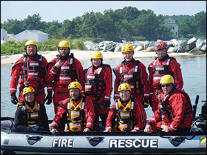
The flooding of Crisfield highlighted the need for well-trained and well-equipped first responders based in Somerset County. The work of the county’s swift water rescue team led to fast funding for two large new Zodiacs, new dry suits, and additional training. Photograph: courtesy of the Somerset County Swift Water Rescue Team
Some of the missing data were real-time temperatures from real-world hurricanes: the right numbers for water temperatures, numbers taken at different levels, both surface and subsurface, and at different times during a storm's progress. According to an analysis published by 48 researchers, the NWS forecasts for Irene and Sandy did not include the right data about a subsurface layer of cold water. The shifts in that cold-water pool, they said, played a role in weakening Irene and strengthening Sandy. When scientists went back later and inserted the right numbers in the widely used Weather Research and Forecasting Model (WRF), the model suddenly clicked: it accurately described the storm surges from Irene and Sandy.
How do you get water temperatures during hurricanes? Boicourt and his collaborators have a plan: when a hurricane arrival is seven days away from the Mid-Atlantic, they will go into heavy watch mode. At four days out, Boicourt and his crews will load their boats, then head out of Ocean City, Wachapreague, and Virginia Beach. Four to five miles offshore, they'll unload into the water a "light buoy," a 300-pounder that can measure temperature, salinity, and wave action and radio the data back to shore during the storm's passage. In one site, probably Wachapreague, they'll also launch an underwater glider, a torpedo-shaped tube that can capture subsurface temperatures as it goes. "Then we'll get the hell out of there," says Boicourt.
Other oceanographers will be unloading buoys and launching gliders in Massachusetts and along the south Jersey shore. Like most contemporary oceanography, this is a collaborative project with researchers working at the University of Maine, the Woods Hole Oceanographic Institution, Rutgers University, and the University of Maryland.
There's excitement about the project, at least among oceanographers. And there is faith, the faith of the scientist: dig up some more data, the right data taken at the right time, feed it into their models, and this time they can get everything right. They can churn out more accurate forecasts for storm intensity and storm surges.
There's also hope, hope that more accurate forecasts will help communities prepare for the stronger storm surges that can come in the near future. Crisfield is still there at the end of a skinny peninsula, and it still sits barely above sea level. And sea level keeps rising.
There were also lessons learned at the local level. Two months after the Crisfield flood, John Barnette got new boats for the rescue team, two Zodiacs big enough to carry eight people at a time. The funding started with an unexpected call, this one from the Maryland Emergency Management Agency. What did the water rescue team need? The team got new boats, new training, new members, and new, bright-red dry suits for all the volunteers.
"It's inevitable it's going to repeat itself," says Barnette, still a man with strong opinions about the Crisfield flood. "The sea level is rising here at a rate faster than it is anywhere else in the world, it seems. And the intensity of the storms will only get worse. But the biggest tragedy of all will be if we fail to learn from it."
In November he motored out on the Wicomico, headed out to dredge oysters, and found the tall green marshes lying flat along both sides of the river, as flat and bald as his backyard after the snow melts. There weren't enough trees or bushes left for a bird to perch on. And his net poles were gone, his tepees washed away in the flood. Sometime later he'd have to tramp into the winter woods and cut new poles. He'd need them come spring to get ready for his summertime crabbing.
|