|
Coastal Radar to the Rescue
Daniel Pendick
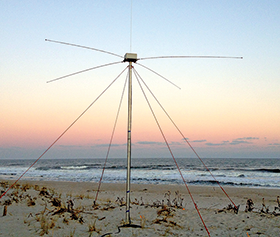
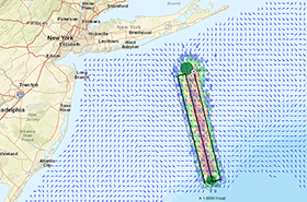
On the beach at Loveladies, New Jersey (above, top), a radar antenna broadcasts microwaves more than 100 miles out to sea, probing the speed and direction of surface currents. The information streams to the U.S. Coast Guard, which uses it to design search patterns (above) to find a vessel or person lost at sea. Photograph, Rutgers University; map, U.S. Coast Guard
WHEN JOHN ALDRIDGE FELL OFF HIS LOBSTER BOAT in the middle of the night off Long Island, his chances of rescue seemed somewhere short of nil. He had no life preserver, his boat was motoring steadily away from him, and his partner, asleep in the forward cabin, would not stir from his bunk for another three hours. When he did wake up, he called the Coast Guard.
The call came in to the U.S. Coast office in New Haven, where personnel responsible for search and rescue in Long Island Sound and coastal Connecticut turned to a computer program called SAROPS — the Search and Rescue Optimal Planning System. This software tool crunches data — like the last known location of a person or ship lost at sea, the type of vessel, wind direction, and ocean currents — and uses all this information to predict the area where rescuers are most likely to find a drifting fisherman like Aldridge.
In the Mid-Atlantic region, SAROPS draws on 41 radars along the coast that measure ocean surface currents. The radar network is operated by the Mid-Atlantic Regional Association Coastal Ocean Observing System, or MARACOOS, based at Rutgers University. It's part of the nationwide Integrated Ocean Observing System managed by the National Oceanic and Atmospheric Administration and its federal partners. Other U.S. coastal regions also have radars and ocean observing systems that feed data to SAROPS.
To contribute to SAROPS operations in the Mid-Atlantic, Hugh Roarty, the Rutgers scientist who manages the radar system, must keep enough of the 41 radars up and running to provide information on currents over more than 100,000 square miles of ocean for at least 80 percent of the time. To do that, Roarty coordinates the work of four radar technicians from Massachusetts to Virginia.
Roarty's team worked hard to attain that 80 percent goal. MARACOOS was ready in spring 2008 to deliver its radar "data product" to SAROPS. The Coast Guard system became fully operational in May 2009.
Here's how it works: Antennae on the shore bounce signals off the ocean surface. Electronic gear converts the radar echoes into digital maps of surface currents, which then go to a computer model that predicts the speed and direction of currents in the near future. Those predictions go to a data server in South Kingstown, Rhode Island, where SAROPS controllers can access them at any time.
At regional Coast Guard headquarters along the Mid-Atlantic, SAROPS controllers draw on the predicted currents and other information to generate search patterns on maps to guide helicopters, planes, and ships. Using information on currents from coastal radar helps to narrow the search area, thus increasing the odds of finding a person or vessel lost at sea.
When John Aldridge was reported missing off Long Island, SAROPS controllers went to work at the New Haven office. Whenever a boater is reported missing in the Chesapeake, SAROPS controllers in Baltimore, Maryland, or Hampton Roads, Virginia, start downloading data. Around the country, SAROPS operators cover 22 million square miles of territory by drawing on other regional radar networks similar to the one managed by Rutgers.
Coast Guard statistics show that its search-and-rescue operations save about 10 people per day, but they lose three. Thankfully, John Aldridge wasn't one of them. Nearly 12 hours after he fell overboard, a Coast Guard helicopter found him. Real-time radar current data from MARACOOS helped SAROPS controllers put their rescue helicopter in the right ocean neighborhood, where a sharp-eyed pilot flying back to Cape Cod was able to spot the lobsterman as he floated in the ocean below, hanging between two roped-together buoys, still hoping for an unlikely rescue.
|