|
Observing the Bay, the Coast, & the Ocean
Daniel Pendick
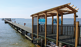
Instruments at the end of the Chesapeake Biological Laboratory's research pier at the mouth of the Patuxent River have measured water quality continuously since 1938. Photograph, Sarah Brzezsinski
CARLOS LOZANO STARTS HIS DAYS at the Chesapeake Biological Laboratory (CBL) by checking a website that displays information about water quality and weather conditions in the Bay. Modern digital instruments at the end of the lab's historic research pier test the waters every 15 minutes. "If I see any issues with it, I'll go out there and check," says Lozano, a research assistant with the University of Maryland Center for Environmental Science. As he marches along a wooden pier that now juts 750 feet out into the mouth of the Patuxent River, Lozano follows in the footsteps of generations who have walked the CBL pier for science. Reginald Truitt, the founder of the CBL, started the monitoring program in 1938. In the early days, instruments were basic; to take the temperature of the water, someone had to walk to the end of the pier and lower a thermometer at the end of a metal tube to a depth of one meter.
Truitt knew that continuous, long-term records were essential to understanding the Bay and exposing future changes. In fact, in 2006 — almost 70 years after the measuring began at the end of his Solomons Island research pier — the record revealed the subtle trace of global climate change in the Bay. And today, the record continues to grow, nearing 80 years long. Regular monitoring remains essential to understanding key processes in the estuary, managing its fisheries sustainably, and anticipating the impacts of climate change.
Since Truitt's time, the business of measuring things has dramatically surpassed the thermometer-on-a-stick approach. The CBL pier has become a point on a nationwide map of coastal observation systems. Networks of sensors keep watch on estuaries, coastlines, the Great Lakes, the continental shelf waters, and the open ocean.
If you have spent time on the Chesapeake Bay, you've probably seen at least one example of the region's observing systems at work: an instrumented buoy. Some of them measure winds, tides, and water temperature and salinity, which ship pilots use to navigate the Bay. Or you may have seen one of the research boats that stop at multiple spots along the mainstem of the Bay to measure dissolved oxygen, nutrient levels, and other key indicators of the estuary's ecological health.
Beyond the mouth of the Bay, other observation systems monitor the Mid-Atlantic coastal ocean. The platforms include shore radars, jumbo-sized buoys, untethered "drifters" that ride the global currents, and torpedo-shaped robotic underwater vehicles that cruise under the waves. Hundreds of miles above, satellites scan the sea surface.
And we have learned important things from this mass of measuring. For one thing, ocean observing has advanced our understanding of the global climate system and our ability to predict it. The Tropical Atmosphere Ocean (TAO)/TRITON array of 70 buoys measures heat in the upper layer of the tropical Pacific Ocean. The array makes it possible to predict the periodic pattern of warming and cooling known as the El Niño Southern Oscillation (ENSO). And it's important to know, because ENSO can affect weather patterns far away. For example, the 2015-2016 El Niño was linked to a snowier winter in Maryland.
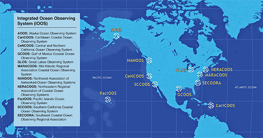
In the early 2000s, the federal government moved to wrangle the nation's multitude of coastal and ocean observing systems into a coherent whole. It came to be called the Integrated Ocean Observing System, or IOOS. This national "system of systems" would also be the United States' contribution to the United Nations-sponsored Global Ocean Observing System.
IOOS, an interagency program led by the National Oceanic and Atmospheric Administration (NOAA), coordinates observing systems spread among 17 federal agencies and scores of universities, research labs, and other organizations. Each of 11 major geographic areas hosts a regional observing system. The Chesapeake Bay, for example, lies within the Mid-Atlantic Regional Association Coastal Ocean Observing System (see map). The "I" in IOOS is integration, shorthand for the ways this program helps observation systems to work together to serve key national needs — like ensuring maritime safety, managing fisheries, protecting ecosystem health, and adapting to climate change.
The Chesapeake Bay region's major observation systems are plugged into the IOOS switchboard. This issue of Chesapeake Quarterly offers stories about coastal observing systems — past, present, and future — and how they benefit the Bay. "The Buoys That Never Sleep" recounts the rise and fall of the Chesapeake Bay Observing System (CBOS), a pioneering effort to continuously monitor the Bay's water and weather. "Where the Wild Fish Are" explains how Bay scientists are working with IOOS to create a national database for tracking the far-ranging migrations of striped bass and other species in the Chesapeake and Mid-Atlantic region. "Coastal Radar to the Rescue" highlights the critical contribution that coastal radar systems make to Coast Guard search-and-rescue missions in the Bay and beyond. Finally, "Better Tools for Cleaner Water" explains how a coalition of federal agencies is working with private industry and academic labs to create inexpensive real-time sensors that could form networks to monitor nutrient pollution in the Chesapeake Bay and many other places affected by this problem.
As the CBOS story highlights, building new observing systems is just the first step. It can be much harder to keep them fully funded and operating, day after day, year after year. IOOS's management believes the key to sustaining support for observing systems is creating successful new "information products" — like a national fish tracking database — that fulfill the needs of multiple users and help them solve important problems.
The benefits of coastal and ocean observing are not always foreseeable in the beginning — as when the signal of global warming emerged nearly 70 years after Reginald Truitt launched the measuring program at the end of Chesapeake Biological Lab's pier. But it's wise to invest in long-term measurement-making because of the many ways it can inform science and natural resource management, says Thomas Miller, the lab's current director. "Monitoring data is one of those things that you don't realize you need — until you do."
A vast network of individual observing systems keeps watch on U.S. harbors, bays, estuaries, coasts, and oceans. A national program, the Integrated Ocean Observing System, coordinates the work of 11 sub-networks aligned with geographic regions. Map, NOAA/IOOS
|