|
The Grand Canyons off Our Coast
Jeffrey Brainard
A diversity of coral and other surprising sea life
species hide in deep gorges in the Mid-Atlantic.
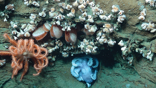
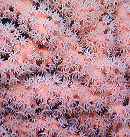
The Atlantic Ocean's deep canyons are home to a diversity of marine life, including corals and other species that attach themselves to rocky ledges (see canyon locations on the map). Here an octopus shares space with bivalves and cup corals ( Desmophyllum spp.). Photograph: NOAA-OER/BOEM/USGS
IT WAS BACK IN 1981 WHEN SCIENTISTS caught an early glimpse of the extraordinary sea life dwelling at the bottom of Baltimore Canyon.
Barbara Hecker was leading an offshore research expedition that year to investigate a little-studied group of deep underwater gorges off the Mid-Atlantic coastline. A benthic ecologist at the Lamont-Doherty Earth Observatory in New York state, Hecker was aboard a ship towing an underwater camera as it crossed one of these chasms, Baltimore Canyon, about 60 miles east of Ocean City, Maryland. The camera took close-up pictures of the ocean floor, and some of these pictures would take Hecker by surprise.
The moment of surprise didn't come until the cruise had ended. The towed camera recorded images on film, and the film had to be analyzed back on shore. This was deep-water exploration in the era before modern underwater digital video cameras that send real-time images to scientists shipside at the surface. It wasn't until Hecker saw the photos that she and her colleagues made an interesting discovery — a large bed of mussels. "The sea floor was totally paved with them," she recalls.
In shallower coastal waters, the mussels would have been commonplace, but in this deeper location near the canyon's rim, they were a big deal. Scientists knew that mussel beds can form around plumes of methane gas leaking from the sea floor. But nobody had ever discovered methane "seeps" along the Mid-Atlantic.
New findings often lead to new questions, and this discovery was no exception. What kind of ecosystem lay hidden in those deep canyons? Were there more methane seeps? Answers to questions like those would have to wait.
The wait lasted for 30 years. In 2011 a new team of scientists launched a three-year series of scientific expeditions that returned to these same offshore locations and explored some new ones as well. This time they brought along remotely operated underwater vehicles (ROVs) that could carry high-definition video cameras hundreds of feet down and use robot arms to collect samples.
On one of their voyages the researchers went looking for Hecker's mussel bed. They found it again and this time discovered many streams of bubbles rising from it. The bubbles were yet more evidence that methane fields were buried beneath the ocean floor.
It was one of many revelations that the scientists would uncover as they studied�� these little-known undersea canyons, launching more than 30 ROV dives and photographing the unusual corals and fishes that favor these ecosystems. Their discoveries would help to fill in gaps in information provided by Hecker 30 years earlier and inform resource management decisions aimed at protecting the canyons from human disturbance. Inevitably these glimpses of the ocean bottom left the scientists with more questions.
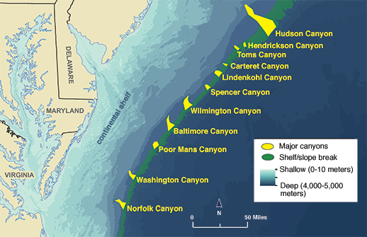
More than 70 large underwater canyons stretch along the East Coast from Virginia to Canada at the edge of the continental shelf, including these off the Mid-Atlantic coast. Baltimore Canyon was created by an ancient channel of what is now the Delaware River. Credit: map, courtesy of The Nature Conservancy/Mid-Atlantic Regional Council on the Ocean
Ancient Valleys
Think of a canyon, and images of the Grand Canyon or the Southwest desert may come to mind. But the earth's ocean floor also has been shaped by geological forces that have created dramatic contours and strange-looking habitats. These are remote, inaccessible, and invisible to us terrestrial residents, but the tools of science can help us to understand them.
Some of these remarkable underwater seascapes lie off the Mid-Atlantic coastline. More than 70 named deep canyons stretch like a necklace from North Carolina to Canada along the outer part of the U.S. Atlantic continental shelf. The heads of these canyons lie between 50 and 100 miles from shore. Their gorges extend miles farther out on the continental slope, the zone where the continental shelf tilts down toward the ocean abyss beyond.
Baltimore Canyon is among the largest of these canyons. Its head begins at about 300 feet below the ocean surface. The canyon extends about 25 miles seaward along the ocean bottom, deepening to hundreds of feet below its rim. Other canyons nearby have similar topography. Most of the abundant life in the canyons abides in complete darkness because sunlight dims rapidly beginning at about 600 feet below the surface.
The canyons are remnants of ancient rivers that flowed long ago across the Mid-Atlantic continental shelf when it was dry land. More than 15,000 years ago, sea levels were lower because cooler temperatures bound the planet's water in glaciers. Baltimore Canyon is located where the early Delaware River flowed across this coastal plain and emptied into the sea at what is now the continental shelf edge. A neighboring chasm, Norfolk Canyon, marks a similar terminus of the early Susquehanna River. In time, temperatures warmed, glaciers melted, and the sea covered the continental shelf. Once flooded, the ancient river valleys continued to be eroded by underwater currents. This natural excavation began hundreds of thousands of years ago, continued as the earth underwent successive periods of cooling and warming, and persists today.
Fishermen know about these canyons as prime locations for catching large, migratory game fish like marlin and tuna, which congregate there. Each summer Ocean City hosts tournaments, and hundreds of charter boats take out fishers eager to hook big quarry.
But the remoteness, depth, and steep walls of these underwater valleys help to explain why until recently their biology and geology were little known. The canyons stood as an exception to the rest of the East Coast's continental shelf, which has been called one of the most extensively studied and mapped portions of the earth's ocean floor. Scientists have used trawling nets to scrape up marine life and sonar equipment to map the shelf's contours. But in the canyons, researchers avoided trawling because the nets would get ripped and lost on the steep walls. Earlier versions of sonar technology had limited capability to map such rugged terrain in detail. The canyons were an unknown world.
But hardly a lifeless one, it turns out. The underwater cameras used in the recent scientific expeditions recorded clusters of brightly colored "bubblegum" coral (Paragorgia arborea), some ten feet high. These are among several coral species that favor ocean habitats deeper and colder than those occupied by the tropical reefs that are more easily glimpsed in the Florida Keys or the Caribbean Sea. Scientists say the Mid-Atlantic's temperate-water reefs may be as abundant, biologically diverse, and ecologically important as their tropical cousins. And the deeper corals live over a wider expanse of the oceans.
Steve Ross, a fisheries biologist at the University of North Carolina at Wilmington, was a leader of the Mid-Atlantic canyon expeditions, and he says that when he shows audiences photos of these deep-sea corals, people immediately connect with these remote places. "They say, 'Oh my god, that's beautiful, I had no idea that was out there,'" he says. "They have the same reaction they would have if I were to show them the Great Barrier Reef. They are all of a sudden a lot more interested and concerned. We tend not to appreciate things that are valuable if we can't see them."
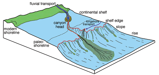
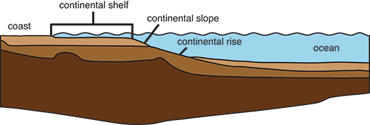
Geological forces formed the Mid-Atlantic's deep submarine canyons over millennia. The heads of these canyons today lie near what was the paleo-shoreline, where ancient river channels once flowed into the ocean when global temperatures and sea levels were lower. Eventually temperatures warmed, sea levels rose, and the ocean reached the modern shoreline. Erosion continued to carve the flooded canyons into the edge of the continental slope. Illustration credits, Adapted from J. Obelcz et. al., Deep-Sea Research II 104: 106-119 (2014) (top); Bureau of Ocean Energy Management (bottom)
What's Down Below
For scientists like Ross, discovering the value of habitat like the Mid-Atlantic canyons requires knowing what they contain. It's a quest that involves more than simply satisfying intellectual curiosity. The federal government has long considered allowing oil and gas exploration and drilling on the Mid-Atlantic continental shelf and slope, and scientists, environmentalists, and federal officials have wanted to know more about how the deep canyons might be affected.
In 2010 the Obama administration was poised to issue leases for exploratory drilling off Virginia. But the administration put that plan on hold after the Deepwater Horizon blowout that year leaked billions of gallons of crude oil into the Gulf of Mexico. Still, federal officials continued making plans for an eventual start of Mid-Atlantic exploration and drilling. Evidence about undersea canyons located in other parts of the world suggested that they contain hot spots of biodiversity housing many species of fish and coral. But deep-sea corals grow very slowly, making them especially vulnerable to the effects of human activities and disturbances like drilling and fishing.
So in 2010, the federal agency that regulates off-shore drilling — the Bureau of Ocean Energy Management (BOEM), part of the Interior Department — invited proposals from scientists to explore the offshore canyons and the life there. Supporting the project were two other federal agencies whose work could also be informed by this research: the National Oceanic and Atmospheric Administration (NOAA), which regulates offshore ocean fisheries, and the U.S. Geological Survey, which maps and studies the ocean floor.
An international team of scientists led by Ross and Sandra Brooke of Florida State University submitted a multidisciplinary proposal that was selected for funding. The research team included coral biologists, fishery biologists, geochemists, geologists, marine archaeologists, molecular geneticists, and physical oceanographers — an array of disciplines that reflected the complexity of the habitat they would investigate.
The scientists were eager to study how the physical features of Mid-Atlantic canyons might support deep-sea corals. One feature favorable for corals is the undersea currents that move up and down the canyons. The canyons act as funnels, carrying food and nutrients from the coast and offshore shelf down to the lower depths inhabited by deep-sea coral. These coral species filter their food from the passing water — a method of survival different from that of tropical corals, which obtain some of their energy from a symbiotic relationship with algae that can perform photosynthesis in the shallow tropical waters. But in the dark regions where deep-sea corals live, photosynthesis cannot occur.
The canyon currents not only carry food for deep-sea corals, they provide a home. Along the canyon walls, currents sweep rocky ledges clear of sediment, exposing the kind of hard, rocky surface on which deep-sea corals typically prefer to attach and grow. Such habitat is rare along the sandy Mid-Atlantic continental shelf and muddy slope zone. That's why evidence of deep-sea corals had rarely been found in previous undersea surveys of the Mid-Atlantic region, Ross says.
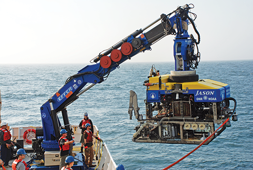
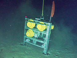
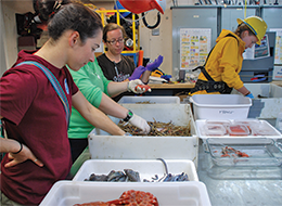
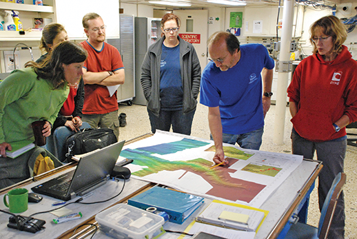
Scientists use a variety of equipment and methods to study the deep ocean and the abundant life it contains. The Jason II unmanned submersible, fitted with robotic arms to collect samples of undersea life, is prepared for launch from the NOAA ship Ronald H. Brown to explore Norfolk Canyon in 2013 (top). Scientists left devices called benthic landers (bottom left) at the bottom of Norfolk and Baltimore Canyons for more than a year to continually collect data on water conditions as well as samples of invertebrate larvae. Researchers used a trawl net to collect fish, crabs, and other animals; here they sort specimens by species for further study (bottom right). Credit, NOAA-OER/BOEM/USGS
Advances in Technology
To see what was living in these depths, the scientists proposed using marine-research tools that incorporated new technology more advanced than the towed camera and other tools used by Barbara Hecker in her research in the 1980s.
One was multi-beam sonar. This technique allows scientists to shoot multiple beams of sound waves at the ocean bottom. Receivers collect the echoes; software constructs a three-dimensional portrait of the bottom that covers a broader area than is provided by earlier types of sonar that shot a single beam straight down. Depending on the water's depth, the multi-beam method can reveal a kilometer-wide swath of the bottom topography at a high resolution, ten meters square. By going back and forth in a gridlike pattern, a research vessel can precisely map areas as large as canyons and bigger. Using this tool, Ross says, "you've got an amazing map of the bottom."
The scientists used this tool to map Baltimore and Norfolk Canyons and other ones during the project's initial research expeditions in 2011. The scientists picked Baltimore and Norfolk Canyons for further in-depth study in part because of their proximity and similarities, which would allow the scientists to compare the canyons' biology and geology.
In return trips over the next two years, the scientists used the detailed maps of the canyons' contours to decide where to lower remotely operated vehicles and other scientific instruments to collect images and samples. They wanted to study a range of topography at different depths to find out what kinds of coral and fish lived there.
The scientific team knew that, even with weeks of ROV dives planned over a two-year period, its time at sea and opportunities for collecting data were limited to spot-sampling a small portion of the canyons' vast area. Indeed, this is the challenge facing ocean research around the world — gigantic areas to study, limited finances to do it. The NOAA ships that support the missions typically cost about $35,000 a day and the ROV submersibles about $25,000 a day. "You get a lot of zeros very quickly," says Brooke, the co-leader from Florida State.
The researchers had the advantage of using one of the most-advanced ROVs, called Jason II, which is operated by the Woods Hole Oceanographic Institution in Massachusetts. ROVs like Jason II can be deployed for more hours at a time and cover a larger area than the crewed, deep-diving submersibles, like Alvin, that conducted many early studies of the ocean bottom. The team also used a second ROV, the Kraken II, owned by the University of Connecticut and named after a kind of sea monster. Like Jason II, it also carried video cameras and tools to collect samples.
A typical day of ROV research started in the morning — when the research team deployed the machine, lowering it to the depths on a long tether — and ended 10 to 12 hours later when they finally retrieved it. In between, scientists worked four-hour shifts, sitting in a special trailer and control room attached to the deck of the research vessel. There they guided the ROV's movements and kept their eyes glued to the live video streaming from its cameras. The days stretched closer to 18 hours straight for the project's lead scientists as they worked to keep the mission operations on track.
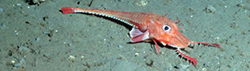
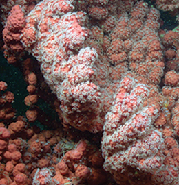
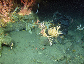
During a 2012 dive, a submersible photographed a number of species that live in the deep canyons of the Mid-Atlantic. Scientists found the distinctive white coral Lophelia pertusa (top left) for the first time in this geographic region. An armored sea robin (Peristedion spp.) uses chin appendages called barbels to feel for food (bottom left). Bubblegum coral, or Paragorgia arborea, (at right) can grow in a fan structure 10 feet tall. Besides pink, other shades of this coral include white, red, and orange. Credit, NOAA-OER/BOEM/USGS
All of that screen-gazing at times made the hours and days blend into each other. But the watching and the waiting were punctuated with whoops of excitement when key discoveries were made. Like during one dive in Baltimore Canyon in 2012.
Brooke had worked eight hours straight in the ROV trailer one morning, a not-so-joyous start to her birthday. "I was freezing cold, and I was really tired, and I went to sit out on deck for ten minutes to warm up. And as soon as I got comfortable, they came charging up and said, 'You've got to get down to the van!'"
She hustled down, "and there on the screen was this massive colony of bright white Lophelia." This is a species of stony coral that the researchers had hoped they might find and study in these canyons. Brooke let out at a salty cry of joy that started with "Holy!"
It was the first time that scientists had observed Lophelia pertusa in the Mid-Atlantic between North Carolina and Cape Cod. The species is widely distributed around the world and is considered a particularly important kind of deep-sea coral because it forms reefs and structures that can provide habitat for fish and other sea creatures. Lophelia comes from Greek words meaning "a tuft of suns," a playful reference to the species' bulbous polyps.
The Lophelia seen in the two canyons was on the small side; none were more than six feet across. Still, it had taken those corals a long time to grow even that big. Based on known growth rates for this species, Brooke and her colleagues estimated that the coral had been growing, undisturbed, for perhaps as long as 400 years. (Lophelia reefs off Norway measure up to 75 feet high and are estimated to be more than 8,000 years old.) They soon found more colonies of the coral in Baltimore and Norfolk Canyons.
According to Brooke, simply finding out that Lophelia lives in a place where it wasn't previously known tells scientists a lot. "If we find these things naturally occurring in a range of habitats, it provides some insight into what their distributional range might be and what their environmental tolerances are," she says. And knowing that range is important as environmental conditions shift because of global climate change. Shift the conditions enough, and some species might not be able to survive.
If indeed the deep canyons are among the few places in the Mid-Atlantic that Lophelia prefers to call home, the finding raised the question of how the coral got there. The closest known Lophelia populations are 340 miles to the north, off Cape Cod, and 190 miles to the south, off Cape Lookout, North Carolina. Brooke and her colleagues estimated that Lophelia larvae, which can live for three weeks, could have been carried that distance by a current. In the open ocean, even a sedentary species like coral can migrate far.
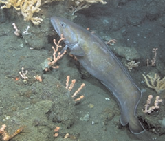
Underwater cameras also captured images of plastic wrapped around coral (bottom left) and rare fish like the cusk (bottom right). During the research expeditions, scientists, including project co-leaders Steve Ross (top, second from right) and Sandra Brooke (top, far right), identified locations on a canyon map for submersible dives. Credit, NOAA-OER/BOEM/USGS
A Refuge for Fish?
The researchers encountered more surprises when they counted fish species in the canyons. During all of the ROV dives in Baltimore and Norfolk Canyons, scientists identified 123 fish species. Many of these have also been found elsewhere in the North Atlantic Ocean, but 12 were not known previously to live in the canyon area. Ross calls this a surprisingly high number of species given that the areas outside the canyons had been more extensively studied by earlier sampling work. "It reflects how little we knew about the canyons," he says.
One of the canyons' secrets might be that they serve as a refuge for fish species that are harvested elsewhere, Ross says. Among the novel species discovered swimming among the canyon walls and coral was cusk (Brosme brosme). This codlike fish is caught commercially in the North Atlantic and is listed by NOAA's National Marine Fisheries Service as a species of concern, meaning the long-term health of the species' population may be at risk.
Another surprise was the size and extent of the mussel beds and the methane seeps (also called cold seeps) that surrounded them. After the researchers examined the mussel bed in Baltimore Canyon that Barbara Hecker had photographed, they investigated an even bigger, newly discovered seep near Norfolk Canyon. This one consisted of two mussel beds, each measuring more than a half-mile in length, and is possibly the largest cold seep yet discovered in the western North Atlantic region.
In both canyons, methane was bubbling through the sediment. On land, methane flows into our homes as flammable natural gas that sustains our heating and cooking. In this deep, dark, undersea environment, the bubbling methane supports life in a biologically unusual way. Colonies of "chemosynthetic" bacteria use methane as an energy source. Mussels living at the methane seeps contain these bacteria in their tissues and consume excess energy from the bacteria for their own metabolic needs. This energy source is far different from that of most other creatures living at these depths, where the food supply is based on photosynthetically derived morsels drifting down from shallower waters. A byproduct of the chemosynthetic bacteria's metabolism is calcium carbonate, which forms hard rocky reefs to which mussels and corals can attach.
This video shows deep-sea corals, fish, methane seeps, interviews with scientists, and other scenes from recent scientific expeditions to the underwater canyons. The video was produced by three federal agencies that sponsored the research — the Bureau of Ocean Energy Management, the National Oceanic and Atmospheric Administration, and the U.S. Geological Survey.
These seeps were just two instances of a large abundance that a separate team of researchers found in the Mid-Atlantic in 2014. Researchers from Mississippi State University and other institutions analyzed data from multi-beam sonar readings taken by the NOAA research ship Okeanos Explorer. The scientists detected 570 previously unknown gas plumes on the continental shelf between Cape Hatteras, North Carolina, and Georges Bank off New England. Many of these seeps were in or near canyons, perhaps because the canyons disrupted and cut through ancient geological layers containing methane, the scientists wrote in the journal Nature Geoscience in 2014. Now researchers are interested in exploring the seeps further to learn more about whether these plumes are emitting methane that enters the atmosphere, where it would act as a greenhouse gas and contribute to climate change.
Moments like seeing the mussels and seeps were why "most dives were pretty exciting," Ross says. "We were in new territory every time."
Considering Conservation
But the ROVs also captured distressing images of canyons. There was plastic garbage, lots of it, and some of it was wrapped around living coral. "Plastic grocery bags, garbage bags, plastic utensils, plates, cups, anything you could imagine," Ross says. "It could have been swept in from shore." Those images, he adds, are a good argument for taking additional steps — like bans on plastic shopping bags — to reduce and recycle plastics in our homes before they spread in the environment, both on shore and off.
The ROV images showed another kind of refuse: lost crab and lobster traps and fishing lines used to harvest squid and other species. Ross and Brooke have conducted similar underwater expeditions in the Gulf of Mexico and southeastern U.S., where, compared with the Mid-Atlantic, "we hadn't seen nearly the number of discarded trawls or traps, and that's pretty significant," he says. Advocates for Mid-Atlantic commercial fishermen have said they avoid fishing in the offshore canyons because they don't want to risk snagging and losing nets and other gear. But "somebody did," Ross says. "The evidence is down there."
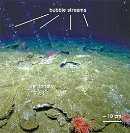
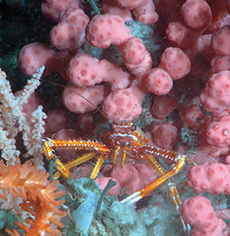
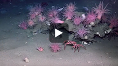
A squat lobster rests among a bubblegum coral, a red tree coral, and a sponge (above right). Researchers captured an image of bubbles believed to be methane gas streaming up from the ocean floor near Norfolk Canyon (above left). "Chemosynthetic" bacteria can use methane as an energy source in a process that creates carbonate, a hard substrate to which corals can attach. Credit, Nature Geoscience, 7:657 (2014) (above left); and NOAA-OER/BOEM/USGS (above right)
This evidence helped persuade policy makers to take action to protect the deep-sea corals and other habitats in the canyons. NOAA scientists had been developing a computer model, called a habitat suitability model, to predict areas of coastal ocean bottom off the northeast U.S. Atlantic coast where deep-sea corals were likely to be present. The model was based on geological features such as slope, temperature, and turbidity. The Mid-Atlantic research expeditions of recent years reported data about the presence and absence of deep-sea corals that helped to confirm that the model's predictions were accurate.
In 2015, the Mid-Atlantic Fishery Management Council used the model to justify a new proposal to restrict fishing in the canyons. Fishers would be banned from using any type of ocean-bottom fishing gear such as trawls, dredges, bottom longlines, or traps in any of 15 discrete zones representing ecologically important populations of deep-sea coral. These canyon areas comprise more than 38,000 square miles, an area nearly the size of Virginia. Among all of these canyon zones, the council ranked Baltimore and Norfolk Canyons as among the most important habitats for coral. If the U.S. secretary of commerce approves the council's proposal, the 15 canyons would be one of the largest protection zones for deep-sea coral in the United States.
The proposal would exempt red-crab fishers for two years. The fishery management council said that only two such boats operate full time in the Mid-Atlantic and their impact may be small (see Red, Not Blue: The Mid-Atlantic's Other Big Crab).
A different kind of potential impact on the canyons — the future development of oil and gas drilling — remains a topic of debate. In 2015 the federal government authorized energy exploration in waters off Virginia from 2017 to 2022. In Virginia, Governor Terry McAuliffe allowed his state's participation in the federal leasing plan. But for now there will be no drilling in Maryland — former Governor Martin O'Malley opted out of the federal plan. Even so, some Maryland elected officials and environmentalists continue to worry about the effects of any oil spill off Virginia on Mid-Atlantic canyons and on Maryland's coastal waters, including the Chesapeake Bay.
In a closeup of a bubblegum coral its extended polyps look like flowers.Credit, NOAA-OER/BOEM/USGS
The recent canyon research expeditions may provide a fresh impetus for government resource managers to take other steps to help protect these special resources. Given that the adjacent continental shelf has been so well studied, "It's pretty astounding that we're still making new discoveries," Steve Ross says. He says the data collected in recent years will help scientists to ask new and better questions about the canyons — like why corals of the same species living in adjacent canyons show genetic differences and how these differences influence their survival. "While this was a really extensive study," he says, "we rushed through a lot of parts because of needing to cover so much territory."
Just as Ross and his colleagues were able to eventually return to the scene of Barbara Hecker's earlier discovery, he hopes that even in a tight fiscal environment for ocean research, scientists will continue visiting the canyons and trying to find more answers.
|