|
June 2016 • Volume 15, Number 2
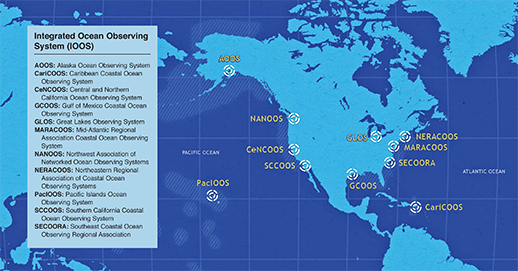
Map, NOAA/IOOS
|
Daniel Pendick
|
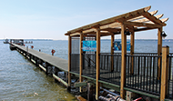
Scientists began monitoring Chesapeake Bay weather conditions and water quality from a Solomons Island research pier in 1938. Almost 80 years later, the monitoring continues, providing long-term records that are essential to understanding the estuary and exposing future changes. Researchers closely monitor not only the Bay but also the coastal ocean beyond in myriad ways. Systems that observe the Bay include chemical tests on water samples collected by hand, internet-connected scientific buoys, and remote sensing from satellites hundreds of miles above the waves. On a national level, the Integrated Ocean Observing System coordinates the nation’s considerable observing assets to find solutions to key national problems. more . . .
|
|
Bill Boicourt had a dream: a network of scientific buoys moored along the mainstem of the Chesapeake Bay, continuously measuring winds, currents, oxygen, and other essential information and relaying this data to the internet for all to use. The data stream went silent after two decades, but the buoys themselves are still contributing to the science of the Bay. more . . .
|
Where do the stripers, sturgeon, and cownose rays roam in the Chesapeake Bay and nearby coastal ocean? A revolutionary underwater tracking technique reveals details about the hidden habits of these and other migratory species. more . . .
|
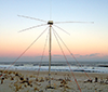
When people or ships are lost at sea, the Coast Guard must find them as soon as possible. To provide data to plot the speediest search strategies, coastal radars measure surface currents more than 100 miles out to sea. more . . .
|
Private companies and academic labs are among the contestants in an innovative competition to invent the next generation of electronic gadgets to monitor nutrient pollution in the Chesapeake Bay and other locations. The new measuring technology could transform the science and management of nutrient pollution. more . . .
|
|