|
Big Year for Bay Storms,
Bad Year for Bay Sediment?
Tropical Storm Lee flushed sediment into
the Bay, but scientists question its effect
Jeffrey Brainard
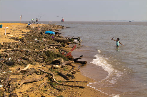
Tropical storms Irene and Lee delivered a one-two punch to the Chesapeake Bay in August and September 2011. They washed detritus such as boards, tree branches, and even propane gas containers into the Bay and later deposited them along miles of Bay shoreline, including here at Sandy Point State Park near Annapolis, Maryland. Photograph: David Harp.
JEFFREY HALKA AND LARRY SANFORD WATCHED as the coring tube disappeared over the side of the RV Kerhin, a research vessel on station in the northern Chesapeake Bay. The tube held a heavy weight that would help the core sink quickly and burrow into the Bay's bottom four meters below.
They worked under a September rain, a reminder that 2011 was turning into one of the wettest years on record. Two big tropical storms, Irene and Lee, had blown over the Chesapeake a few weeks earlier, dumping torrential rain on the region. The Bay's water was still brown.
As they worked, the two scientists had an older, more famous storm in mind. Halka is director of the Maryland Geological Survey and Sanford is a professor at the Horn Point Laboratory, part of the University of Maryland Center for Environmental Science. Both had studied the history of Tropical Storm Agnes, the 1972 storm that caused the greatest flooding in the Chesapeake in modern times. Halka and Sanford were taking sediment samples that September day from the same area of the upper Bay, near Aberdeen Proving Ground, where researchers had found some of the thickest deposits of sediment following Agnes. That sediment onslaught is seen as an important reason for a big die-off in the following years of oysters and underwater grasses.
Halka and Sanford hoped the samples would show how much new sediment was deposited by Lee on the Bay's bottom. They knew that the tropical storm had caused the second-largest water flow since Agnes in the lower Susquehanna River, the Chesapeake's largest tributary. Had a new layer of life-smothering mud flushed into the Bay?
Their preliminary findings, and those of other researchers, offer hope for optimism. But they also underscore how little is known about the effects of big storms on the Bay's ecology.
One for the Record Books
After Agnes hit in 1972, scientists produced a thick bound report about its effects. The volume contains some startling numbers illustrating why that storm remains a historic benchmark and case study. During a three-day period in late June, the tropical storm (which started as a hurricane on the Gulf Coast) dumped up to 18 inches of rain in pockets of the Susquehanna River watershed and, across all of it, an average of 8 inches. The watershed was already soggy from heavy spring rainfall.
The result was an epic torrent. For the 10-day period after the start of the rains, the flow averaged 15 times normal, and peaked at 30 times normal. This in turn sent a huge slug of sediment into the Chesapeake Bay: an estimated 30 million tons. Today, the average annual flow of sediment from the Susquehanna is only about 1.5 million tons. It was more sediment than had been discharged from the Susquehanna during all of the preceding 10 years and perhaps a quarter-century. The flood acted like a time machine: in only two weeks, the upper Bay had aged the equivalent of 10 to 25 years in geologic terms.
The sediment — which is essentially river mud, made up of sands, silts, and clays — came from riverbanks and runoff from fields and lawns. The post-Agnes scientific report estimated that nearly a foot of new sediment was deposited at points in the upper Bay, north of the Bay Bridge, between Turkey Point and Tolchester Beach, Maryland. Up to one meter went into the shipping channel in that area.
The scientific assessment also found that the impacts of this deluge were especially severe around the Susquehanna Flats, the shallow area at the mouth of the Susquehanna River. The underwater grasses, also called submerged aquatic vegetation, lay directly in the path of inundation. The assessment estimated that the volume of vegetation declined by 67 percent. A year before the study, aquatic plants covered 29 percent of the area measured; a year later, they covered only 10 percent.
Agnes's timing could hardly have been worse because June is when underwater grasses are just sprouting. The grasses are important in the Bay's ecology because they provide habitat for juvenile fish and enhance water clarity by trapping and removing sediment from the water.
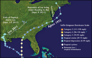
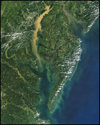
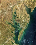
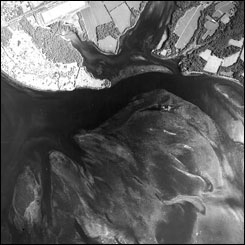
Tropical Storm Lee turned the Chesapeake Bay brown (bottom left, satellite photo from September 2011) as silt and clay from the Susquehanna River and other sources swept in. Tropical Storm Agnes, in June 1972, caused the biggest single load of sediment on record. As shown by their tracks (top), neither storm was a hurricane by the time it reached the area — but both generated loads of rain. Sediment also muddies the Bay each spring when it is swept in with snow melts (bottom right, satellite photo from April 2011) and from winter storms, like the unnamed one in January 1996 responsible for the second largest sediment dump from the Susquehanna River. Source: storm tracks, National Hurricane Center; satellite images, National Aeronautics and Space Administration.
Sediment from the Dams
Even during normal conditions, sediment flow from the Susquehanna has a big influence on the upper Bay. The river is the Bay's largest single nontidal source of sediment, contributing about a quarter of the total. Tides sweep additional amounts of sand from the Atlantic Ocean and deposit it in the lower Bay.
But under the abnormal conditions of a big storm, the flow of sediment from the Susquehanna to the Bay is magnified. That's because the lower Susquehanna is home to three hydroelectric dams that are holding back millions of tons of sediments that have been trapped behind them during their decades of operation (see Countdown for the Conowingo). High river flows can scour out several million tons in just a few days, more than the 1.5 million tons reaching the Bay in an entire year.
In earlier decades when it was healthier, the Chesapeake's ecosystem was better able to withstand a storm-driven pulse of river mud. Aquatic vegetation bounced back in as little as two to three years after a series of big storms hit the Bay in the mid-1950s, research indicates. (They were Hurricane Hazel, in 1954, and tropical storms Connie and Diane, in August 1955.) Agnes was unusual in that the vegetation declined precipitously and then stayed low for years after. It didn't help that levels of nitrogen and phosphorus in the Bay continued to rise after Agnes. Nutrients remain high today and continue to make the Bay more vulnerable to the effects of big storms than it otherwise would be.
Lee, which hit the region in early September 2011, was mercifully far smaller than Agnes. (Irene dumped high rainfall on the Eastern Shore in late August but less in the Susquehanna watershed.) The U.S. Geological Survey estimated that the Susquehanna delivered less than half as much water to the Bay after Lee than it did post-Agnes. Lee also brought less sediment, about 4 million tons, compared with Agnes's 30 million. Even so, the flow after Lee ranks ahead of most other storms on record for river flow in the lower Susquehanna. That's why scientists were curious about the storms' effects on aquatic vegetation in the upper Bay, including the beds at the Susquehanna Flats. Researchers had recorded a resurgence of growth there during the past five years. Had Lee brought sediment on anything like the scale of Agnes?
During their trip in September on the Kerhin, Halka and Sanford obtained a series of eight cores, or meter-long samples, of sediments, following a north-south line in the upper Bay. While the research is still incomplete, the researchers found evidence of a sediment dump that was modest in comparison with that from Agnes. In the same location where researchers had identified 20 centimeters of new sediment from Agnes, Sanford and Halka found a surface layer, measuring about 5 centimeters, of what appeared to be new sediment. The light-brown, soft material contrasted with grayish sediment beneath that was probably older. It made sense, Sanford says, that the layer identified from Agnes measured about four times the depth of the one found after Lee. Estimates are that Agnes scoured about four times as much sediment from behind the Susquehanna dams as did Lee.
However, the scientists found only 1 to 2 centimeters of apparently new sediment at other spots around the upper Bay that day and during a separate cruise in October south of the Bay Bridge. It was déjà vu for Halka, who had done similar testing for sediment after a big, unnamed storm in January 1996. He had found no evidence then of sediment attributable to that storm.
The apparent lack of sediment this year is "surprising," says Halka. "We're still scratching our heads about how sediment is delivered to the Bay [during a storm] and what happens to it once it gets there."
Significant Storms over the Susquehanna River Watershed
|
|
| Storm |
Year |
Month |
Peak flow
(cubic feet
per second) |
Average
recurrence
of storm
that size* |
Sediment
scoured from
Conowingo Dam
(million tons)* |
|
|
| unnamed |
1936 |
March |
798,000 |
~100 years |
n/a |
| Hurricane Agnes |
1972 |
June |
1,130,000 |
~300 years |
20 |
| Hurricane Eloise |
1975 |
September |
710,000 |
~50 years |
5 |
| unnamed |
1993 |
April |
442,000 |
~10 years |
2 |
| unnamed |
1996 |
January |
909,000 |
~200 years |
12 |
| Hurricane Ivan |
2004 |
September |
620,000 |
~30 years |
3 |
| unnamed |
2011 |
March |
487,000 |
~10 years |
2 |
| Tropical Storm Lee |
2011 |
September |
778,000 |
~30 years |
4 |
* Estimates subject to margins of error. |
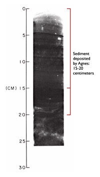
Large storms can threaten the Bay's ecology by dumping large amounts of sediment and nutrients into the Bay, choking off submerged aquatic vegetation. But as the table at left shows, most of the largest storms to hit the Bay came during the winter or fall, when those plants are dormant or near the end of their growing season. Tropical Storm Agnes was a devastating exception, hitting in June 1972 at the beginning of the growing season. The sediment core above right measured some 15-20 centimeters of sediment dumped by Agnes in one location. Scientists like Larry Sanford (left, with sediment core) predict that if the reservoir behind the Conowingo Dam on the lower Susquehanna River fills up with sediment, the amount scoured out by big storms and sent to the Bay will increase. Source: table, U.S. Geological Survey and Exelon Corporation; sediment core Graphic, Courtesy of the Chesapeake Research Consortium. Photograph: Jack Greer.
The Art of Measurement
The science of measuring and tracking sediments around the Bay's bottom, it turns out, involves some tricky sleuthing. Researchers who study them have used a variety of methods.
Visually inspecting the cores can be deceptive, Sanford explains. Color is not necessarily an indication of age; certain geochemical processes can make older sediments look light brown, too.
Researchers are examining another line of evidence from X-ray photographs of the cores. This was the primary method used in the 1970s to study sediment deposited after Agnes. However, just as physicians can draw different interpretations of the same X-rays of a human lung, so can geologists when examining X-rays of sediments. Where the earlier scientists reported that one post-Agnes sample showed a sediment layer of up to 20 centimeters, Halka draws a different conclusion: "I'd say there's only one or two," he says. This raises intriguing questions about whether Agnes indeed deposited as smothering a load of sediment as is commonly thought.
One of Sanford's colleagues at Horn Point Lab, assistant professor Cindy Palinkas, is using yet another gauge of age to study the sediments obtained after this year's storms. The method, not available to researchers in the 1970s, uses a radioisotope called beryllium 7. The element becomes attached to sediments when they are above water. The isotope has a half-life of only 53 days (it loses half of its radioactivity in that span), so its presence in bottom sediments suggests that they were recently washed into the Bay. The results of this method indicate that the 5-centimeter layer from the core taken near the Sassafras River was indeed recently deposited there, as were the 1- to 2-centimeter layers in the other samples taken farther south. That suggests that the sediments were deposited there by Lee — but not to the depth that scientists anticipated.
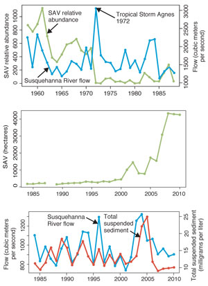
The abundance of submerged aquatic vegetation in the Susquehanna Flats area (top, shown in green, on a relative scale) plunged after Tropical Storm Agnes. But data for 1984 to 2010 (middle), which are based on a different method, show a large increase in recent years. The concentration of total suspended sediment (bottom graph, in red) follows closely with flow (blue) from the Susquehanna River. Figures by Cassie Gurbisz, UMCES Horn Point Lab; data from a variety of sources.
"It's clear that the system isn't operating the way we expect," Palinkas notes. "We expected to see all of the sediment concentrated in the northern part of the Bay. It may be instead that a thinner layer is being spread out over a wider area. From a biological standpoint, SAV [submerged aquatic vegetation] and oysters can do better with a dusting than getting dumped on."
Sanford adds that learning more about where sediments go during storms would require collecting more data from more locations. But it's difficult to finance and organize a short-term research effort like that. Scientists funded by research grants work on long time scales.
"We get these massive events [storms] every once in awhile," Sanford says."And they remind us that they probably have, although we don't really know, a big impact on the system. But it's so hard to try to organize a research program around unpredictable large storms, that we never really answer that question. And then we wait for the next event."
Another effect of Lee was that the remaining oysters of the upper Bay were decimated, the Maryland Department of Natural Resources announced in November. But biologists add that the oysters were probably done in by high freshwater flows from rainfall earlier in 2011, before the two tropical storms arrived. Sediment may not have played an important role. What's more, the upper-Bay oysters represent only 2 percent of the Bay's remaining population.
One big question mark is Lee's effect on submerged aquatic vegetation. How much sediment the plants can survive — and at what point a survivable dusting of river mud turns into a fatal dump — is among the storm-related questions that scientists haven't studied in depth. But the Susquehanna Flats may provide some clues.
Survival of Aquatic Grasses
Submerged vegetation in the Flats has represented a bright spot in the Bay's recovery. The bed had grown from nearly nothing in 1984 to 8 kilometers wide by 2009. Just as high flow from the Susquehanna has threatened the bed, a drought has seemed to help: its growth accelerated in 2005 after several consecutive years of low flow, says Cassie Gurbisz, a graduate student at Horn Point Lab who has studied the bed. The lower flow, she says, would have resulted in lower delivery of sediments and nitrogen from the river's mouth.
After this year's storms, Gurbisz and other scientists had to hold their collective breath to learn what had happened to the grass beds. Their condition, and that of submerged aquatic vegetation along the length of the Bay, have been charted annually through aerial surveys sponsored by the Virginia Institute of Marine Science. However, Lee blew across the Chesapeake just before the program had planned its annual overflight of that part of the upper Bay. For weeks afterwards, the water was too opaque to justify the cost of an overflight, because sponsors knew they would get no useable images.
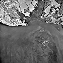
An aerial photo (top) of underwater grasses in the Susquehanna Flats, taken in November 2011, shows abundant vegetation (light areas) and little change from photos taken the previous year. This suggests that this year's storms may have left intact the grass beds, which have grown significantly since 2001 (bottom), when they were scarce. Source: Annual Submerged Aquatic Vegetation Monitoring Program, Virginia Institute of Marine Science.
The water didn't clear sufficiently until the first week of November, when a flight was finally sent up. The result: it appeared that the flats were largely intact.
"We were pleasantly surprised or even shocked," says Robert Orth, a professor at the Virginia Institute of Marine Science who oversees the overflight program. "Just visually comparing what the Bay looked like a year ago, one would not have known there was a big storm." He adds, "We think the size of the bed played a role in mediating those effects." But next year's growing season will provide more proof, he says.
Some damage to the bed seems likely, says Michael Kemp, a professor at Horn Point Lab and Gurbisz's advisor, who has extensively studied the Bay's aquatic vegetation. The latest photograph may show what is actually "a good bit of dead, standing plant material," he says. "We hope for the best, that the bed is going to come back. I doubt that it will come back like it has been in the previous four or five years." He adds, "We'll surely learn something from [those effects]." But he calls the storms "depressing" because he and his colleagues were planning to conduct further research to better understand the reasons for the bed's resurgence. The storm's effects will likely muddy those results.
Still, the storms could have done more damage had they hit in June, as Agnes did in 1972. The importance of timing was underscored by an analysis published in 2005 by Ping Wang and Lewis Linker of the U.S. Environmental Protection Agency's Chesapeake Bay Program Office. They used a computer model to simulate the impact of storms on submerged aquatic vegetation at different times of the growing season. The model suggested that peak growth of vegetation for the season fell by about half following a July storm but by a smaller amount following a September storm. Storms also weakened the plants so that peak growth remained lower than average the following year.
Another important effect of this year's storms could be the increased loads of nitrogen and phosphorus washed into the Bay. They could drive algae blooms next summer that in turn could result in another record year of hypoxic "dead zones." Scientists plan to conduct more analysis and aerial surveys next year — the 40th anniversary of Agnes — to understand better how this year's storms stack up against that catastrophe.
|