|
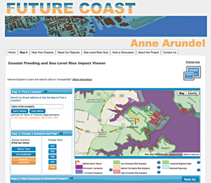
Picture Tells Story of Future Flooding
SEEING, AND LISTENING, really does equal believing when it comes to sea level rise and the risk that it will worsen flooding around the Chesapeake Bay.
A research team led by George Mason University recently tested new ways of communicating about these risks. The researchers invited 40 residents of Anne Arundel County, Maryland, to a daylong forum. The citizens were asked to view an interactive online map, which showed neighborhood-level details about the risks and possible property damage from increased coastal flooding predicted in the coming decades. Participants also asked the Maryland scientists and policy makers questions about sea level rise.
In polls given before and after the forum, attendees were more likely to label sea level rise a growing threat to the county after the event. The research team posted its findings and map online at: www.futurecoast.info. An online news article by Maryland Sea Grant about the project is at: www.mdsg.umd.edu/news/future_coast.
|