|
Going to Extremes
The Storm over Hurricanes
Michael W. Fincham
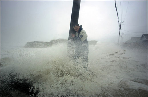
On its way to the Chesapeake Bay, Hurricane Isabel makes landfall across the Outer Banks of North Carolina on September 18, 2003 (above), sending Bill Ackliss of Kitty Hawk scrambling for cover. A hurricane is a tropical cyclone that sucks its energy from warm oceans and moist air, cycling heat upwards and radiating it out to space. A huge storm cools off the ocean it passes over, leaving a cold wake and lowering the likelihood that a new storm will follow the same track. On land it leaves another kind of wake: property damage, death, and flooding.
Credit: Drew Wilson/The Virginian Pilot.
WHEN STORM WAVES CAME SURGING INTO THE CRAB HOUSE, young Art Daniels started running for home. With the main road flooded, he headed for high ground, dodging a falling tree knocked over by gale force winds. The great August Hurricane of 1933 was hitting the Chesapeake Bay and Daniels would have a front-row seat. Reaching home he perched next to an upstairs window and watched storm winds and waters start to tear his world apart. His world was the fishing village of Wenona down on the southwestern edge of Deal Island, a pear-shaped island hanging like soggy fruit off the marshy wetlands of the lower Eastern Shore of Maryland.
He was 12 years old and here are some of the things he was seeing: The waters his father fished for blue crabs and oysters were crashing onto the island, driven north by the storm surge from winds blowing straight up the Bay. The garden his mother planted was flooding with saltwater, killing off her butterbeans and potatoes and onions and strawberries. The chickens the family kept for daily eggs were drowning under the house. In island cemeteries, coffins were floating out of their graves.
From his window, Daniels could see the big shucking house down the road start shaking apart as wave after wave hit, sending boards flying off the building. "I watched them big seas come in and tear that house down. The next morning there weren't but a few poles left standing," says Daniels, an 89-year old waterman getting ready for another oyster season. "That left an impression on me about the strength that the water has."
Storms leave memories, marking people as well as the land. Daniels remembers the gale of 1933 as the August Storm. Others called it "The Storm King," or the "Chesapeake and Potomac Hurricane," and by any name, it was clearly the storm of the century for Tidewater Maryland and Virginia. The devastation down on Deal Island was happening all around the Bay. In small villages the storm wrecked boats and bridges and businesses, and its storm surge flooded into Norfolk, Annapolis, Baltimore, and Alexandria, some ninety miles up the Potomac. At Ocean City, Maryland, it cut an inlet to the sea, separating the city from Assateague Island to the south. In its wake, it left forty-seven people dead. In all, the storm season for 1933 set a record with 21 tropical cyclones forming in the Atlantic.
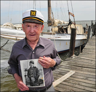
Down on Deal Island, skipjack captain Art Daniels has seen and survived all the famous hurricanes of the last 90 years. When Hazel came through in October of 1954, crabbers lost their pots, fishermen lost their nets, and Deal Island lost its bridge. By the time Daniels went oystering again, his boat had a new rudder — a heavy plank from the blown-apart bridge. It still steers his boat.
Credit: Salisbury Daily Times/Patty Hancock.
Since 1933 Art Daniels has seen a number of famous storms roar though the Chesapeake region — including Hazel (1954) and Agnes (1972) — all of them bringing high winds, heavy rain and floods. Then in September of 2003, Hurricane Isabel struck. Matching the fury and flooding of 1933, Isabel raised questions and fears about future storms. What kind of extreme weather is coming and where is it going to hit? Those are the forecasts that officials need for identifying floodplains, that homeowners need for building or buying or abandoning houses, that emergency services need for hiring staff or acquiring equipment.
As the planet warms and sea levels rise in the Chesapeake Bay, what can current science now say about the storm next time?
These are hot-button issues in storm science and debate over them has been heating up since 2005. That was the year that broke the 1933 record for storms. It was also the year Hurricane Katrina tore apart the city of New Orleans. Shortly before Katrina struck, an atmospheric scientist named Kerry Emanuel published a landmark study in Nature that tried to chart how global warming might change hurricane frequency and intensity. His study stirred up a storm in both the popular media and the hurricane research community. It held some good news, some bad news, some worse news.
The good news: the warming of the planet may not create a greater number of storms for the East Coast. According to Emanuel, an atmospheric scientist at the Massachusetts Institute of Technology, there were no detectable trends in recent data that indicated storms would become more frequent, and the predictions from climate models were inconsistent on this question. His forecast for no increase in storm numbers was supported by other scientists, some of whom suggested that global warming could, in fact, lead to fewer storms.
The claim seems, at first, counter-intuitive. For decades now, scientists have viewed hurricanes as heat engines fueled by water vapor evaporating off warm seas. Born as tropical cyclones, hurricanes suck heat out of the oceans, the planet's great heat reservoir, and cycle it upwards through convection into the cooler air of the upper atmosphere. The warming of the oceans should be releasing more water vapor into the atmosphere and more water vapor usually leads to more thunderstorms in the Atlantic.
More thunderstorms, however, may not lead to more hurricanes. The forces that organize thunderstorms into a rotating tropical cyclone are numerous, complicated, and highly variable. Heavy rainfall in the Sahel region of West Africa seems to precede storm formation and so do shifts in the North Atlantic Oscillation (NAO), an air mass that moves back and forth between Iceland and the Azores. More distant events also affect storm startups. In the Eastern Pacific, episodes of warming waters known as El Ninos seem to suppress hurricanes in the far away Atlantic, and episodes of cooler waters in the Pacific known as La Ninas seem to encourage them. One of the strongest storm drivers is the recently discovered Atlantic Multidecadal Oscillation (AMO), a pattern of changing ocean currents. It alternates between warming episodes which feed tropical cyclones and cooling patterns which starve them.
When the August Storm of 1933 hit Deal Island and sent Art Daniels running for home, neither he nor any scientists of the day suspected that this roaring storm was shaped by forces like rainfall in Africa and cool waters in the Pacific. All these climate connections — unknown in 1933 — are the hard-earned discoveries of very recent decades. These discoveries began as statistical correlations, many of them first identified by William Gray and his proteges at Colorado State University. Correlations, however, are not an end point in science: they are a starting point for figuring out causal connections.
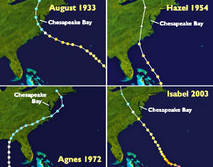
STORM TRACKS TELL A STORY. Hurricanes and tropical storms that create the most dramatic storm surges in the Chesapeake have one thing in common: they sweep northwards along the west side of the Bay's mainstem. Official records and human memories report strong surges and heavy flooding from these monster storms: the August Hurricane in 1933, Hurricane Hazel in 1954, and, most recently, Hurricane Isabel in 2003. In each case the eye of the storm stayed west of the Chesapeake Bay. more . . .
No wonder it's not easy predicting hurricanes. All these climate events vary over time, sometimes reinforcing each other to create busy storm seasons, sometimes undercutting each other to suppress storm formation. Since some of these large climate patterns can last for decades, busy storm seasons and slow seasons tend to come in clumps. The 20th century began with 25 years of slow storm seasons, followed by 40 years of busy seasons, then 25 years of quieter seasons.
Since 1995, the Atlantic region has been experiencing another era of busy storm seasons, an era we may be stuck with for a while. According to Emanuel and other scientists, the high number of hurricanes over the last decade was not the result of man-made global warming — it was served up by these long-standing natural patterns.
The bad news according to Emanuel: while future storms may not be more frequent, they will probably be more ferocious. The theory behind bigger storms came right out of the heat engine model. Global warming could be pumping more high-octane fuel into the cyclone engine. "In theory, warming would increase the energy source for hurricanes," says Emanuel. "That would increase the violence of hurricanes."
His grim forecast for bigger storms, however, is based on more than theory. Emanuel was citing statistical evidence that storms had been growing more powerful. After compiling an index of power dissipation based on wind estimates, Emanuel showed that storm power had already doubled over the last 30 years. Wind speeds were running nearly 50 percent higher since the 1970s, he said, and storms were lasting nearly 60 percent longer since 1949. His key finding: this trend in rising storm power correlated closely with rising sea surface temperatures. Future warming, he warned, could lead to even more powerful storms in the 21st century.
This bad news forecast was big news because it came from a well-respected researcher and it arrived right before Hurricane Katrina. Two weeks after he published his findings, Hurricane Katrina inundated New Orleans. His predictions — and his impeccable timing — seemed to elevate Emanuel into prophet and point man for a hurricane-global warming link. His forecast was not only featured in newspapers and magazines — it also showed up in Al Gore's movie
An Inconvenient Truth. In the year of Katrina, Emanuel also published
Divine Wind: The History and Science of Hurricanes, a non-technical book designed to explain hurricanes to the general public. The following year Time magazine anointed him one of the 100 most influential people on the planet.
Hurricanes were now launched into the popular media as another symbol of global warming, ranking right behind melting ice caps and stranded polar bears. The implications seemed clear: With global warming the great storms of the near future might become monster storms. Isabel in the Chesapeake and Katrina in the Gulf might have been harbingers that something really wicked this way comes. Instead of King Kong, think Godzilla, the creature from the deep that could wreak vengeance on whole cities.
In the storm science community, however, the debate over big storms had just begun. Scientists from different camps were already working to verify or disprove the alleged link between global warming and hurricanes. This critical back and forth is a natural part of science, a kind of slow, self-correcting machine that usually hums along barely noticed by the media, with claims and counterclaims launched in scientific and technical journals. Support for Emanuel's claims came quickly from research findings that Peter Webster of the Georgia Institute of Technology published in
Science for September of 2005. Analyzing tropical cyclones in six ocean basins, Webster found that the proportion of storms reaching Categories 4 and 5 had doubled over the last 30 years.
Critical response to Emanuel was just as quick. Leading off with a critique also published in
Science was Chris Landsea, who thought the intensity of recent storms could be explained by those natural climate forces. There was probably no long-term trend toward more powerful storms, says Landsea, now a meteorologist with the National Hurricane Center. If the storms of 50 years ago were measured with contemporary techniques, the older storms would probably prove just as powerful as recent storms. Earlier storms, said Landsea, may have been underestimated. There could also be "missing storms" that never made it into the record, he suggested, because scattered sightings did not produce reliable wind estimates. Until the historical record is reanalyzed storm by storm to create an accurate database, it will be difficult to identify real trends by looking at storm history.
The dividing question in the debate: Were the powerful storms of recent years caused, at least in part, by global warming? Or were they largely the offspring of a warm phase in ocean currents caused by the Atlantic Multidecadal Oscillation? Emanuel would vote for Option A. Landsea would vote for Option B.
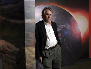
Kerry Emanuel of the Massachusetts Institute of Technology was one of the first scientists to cite evidence that warming oceans were fueling more ferocious storms. More bad news: global warming would also bring heavier rainfalls and greater flooding, dangerous threats in regions like the Chesapeake, which are already vulnerable to sea level rise.
Credit: Jody Hilton/The New York Times/Redux.
To make sense of the ongoing debate, the World Meteorological Organization last year brought Emanuel and Landsea together to meet with eight other researchers at Sultan Oaboos University in Oman on the Arabian Peninsula. Their charge: begin a review and evaluation of all the recent research in theory, observation, historical analysis, and climate modeling. Don't just pick strong findings and throw out weak ones, but highlight uncertainties and suggest levels of confidence. The goal was to provide guidance to national weather organizations who in turn advise state and county and city officials who need to make long-range plans for protecting people and property against extreme weather.
The final report from this team of experts, published this year in
Nature Geoscience, represents the latest effort at a consensus on the hot-button questions in storm science. As such, its findings are as carefully worded as an international treaty on nuclear weapons. On the hottest question, the hurricane-global warming link, the experts found they could not "conclusively" link past storms to man-made contributions to global warming, a nod to Landsea's arguments. In a nod to Emanuel's claims, the experts agreed future storms will probably be more intense because of global warming, a projection based both on theory and on high-resolution models.
Are ocean waters warming up around the planet? Yes, agreed the experts, and the waters are warming faster in the Atlantic basin. Much of the global increase, they said, is probably due to greenhouse gases. As water temperatures are rising, so is total storm power as measured by wind power, a correlation that was a key finding in Emanuel's landmark 2005 paper in
Nature. And both water temperatures and storm power are rising faster in the Atlantic basin, the region that spawns the tropical storms and hurricanes that could hit the Chesapeake.
Would monster storms, like Isabel in the Chesapeake or Katrina in the Gulf become more frequent? "More likely than not," said the experts. And in this judgment they felt "a higher confidence level" than before. All that careful language is science-speak for "yes, probably."
In 1933 the roaring of the ocean could be heard eight miles inland along the main street of Snow Hill, Maryland. The roaring went on for two days and was one of the few warnings Marylanders had that the great August Storm was headed their way. So wrote Reginald Van Truitt, the scientist who founded the Chesapeake Biological Laboratory and later published
High Winds, High Tides: A Chronicle of Maryland's Coastal Hurricanes.
Marylanders seem to have much more warning now — at least for the storm next week. For short-term alerts, the National Hurricane Center has two geostationary satellites hanging 22,000 miles above the earth and keeping constant watch on the tropical ocean regions where warm waters give birth to great storms. The National Weather Service also has a staff of scientists working up storm track forecasts to help city and state officials decide on evacuation alerts and homeowners decide on house protection. In 1964 the weather service began sending out three-day forecasts. In 2003, nearly 50 years later, the weather service began giving five-day forecasts. The next goal is seven-day forecasts.
Marylanders also have more warning about the storms next year. Scientists with the National Hurricane Center can be stunningly accurate with their seasonal forecasts, largely because they are able to accurately monitor and model those great shifts in air masses and ocean currents in two oceans that create hurricanes in the Atlantic. The 2010 season, for example, was one of the busiest on record with seasonal forecasts calling for 8 to 12 hurricanes, a prediction that proved dead-on when the storm season this year produced 12 hurricanes in the Atlantic.
But the warning Marylanders really want is this: When will those big storms of the future arrive in the Chesapeake? And where will they make landfall? That's the kind of forecasts planners and homeowners and businesses need — but it's the kind of help storm science cannot give. "When it comes to predicting regional events, people want answers," says Emanuel, "but science really doesn't have answers."
When storm scientists try to figure out future storm tracks and landfalls, they bump up against some fundamental forecasting limits. Storm theory, in effect, runs into chaos theory, the discovery of a meteorologist named Edward Lorenz who made "the butterfly effect" famous. Chaos theory shows that omitting or changing a few data points in a model — perhaps by rounding off decimals in wind estimates — will have a huge effect down the line on the model's weather forecasts. If your model leaves out the wind effect from the flapping of a butterfly's wings, for example, your long-term forecasts will be wildly off. Since computer models can never hold every data point, they will always miss the butterfly's wings. "Because of chaos theory," says Emanuel, "it is impossible to predict beyond two to three weeks."
Last storm season illustrates those limits. Scientists were able to predict months ahead of time how many storms would form in 2010. But to predict where storms would land, climate modeling has to segue into weather forecasting — which is the art and science of reading pressure systems and troughs and jet stream wanderings, all the short-term forces that can steer big storms toward the Gulf of Mexico or the Outer Banks or the Chesapeake Bay. Or out to sea.
Last season all the major hurricanes went out to sea or landed elsewhere. Though 2010 was one of the busiest hurricane seasons in half a century, few Americans noticed. Twelve hurricanes fired up in the Atlantic basin, but in a statistical rarity, not one hurricane made landfall in the U.S. "To the man in the street, it was a dead season," says Emanuel. "What we can predict and what we can measure are not necessarily what people would like to know."
If you would like to know whether future storms will be more intense, whether they will bring greater storm surges into floodplains, whether they will bring heavier downpours with greater flooding, Kerry Emanuel can tell you "Yes," and say it with a high confidence level.
But ask him whether those great storms will come to the Chesapeake, or to your county, or to your house — and he has no confidence beyond two to three weeks. "You can't do better than that," he says, "not if you threw all the resources in the world at it."
For local officials worried about floodplain planning and affordable insurance policies, Kerry Emanuel is willing to offer some advice, but when he does he sounds like one of those angry prophets out of the
Old Testament. "I tell them to forget about climate change," he says, "and deal with the 800-pound gorilla that is staring them in the face." Federal caps on flood insurance rates and federal disaster relief for homeowners are encouraging people to live in risky places. "It taxes the rest of us," says Emanuel, "to subsidize people who are facing future catastrophes."
Wouldn't he like a house next to the water? His choice in that case, he told
The New York Times, would be "the Fire Island option." Build a flimsy house you don't mind losing. When it gets flooded out or blown apart, simply build it again.
His solutions for the rest of us: Don't build in high-risk floodplains. If you have to live by the water, then build a fortress home that can withstand huge storms. Or elevate your home well above the floodplain. Or pay high insurance rates that reflect real risk, the risk that the monster next time might come to your door.
|