|
The Highs and Lows behind Boom and Bust Years for Chesapeake Bay Fish
Michael W. Fincham
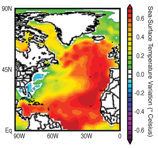
The reddish zones above indicate the areas where sea-surface temperatures fluctuate during the AMO cycle. This map shows a warm phase. Source: NOAA Earth System Research Laboratory
FISH POPULATIONS ARE DRIVEN, in part, by regional-scale weather patterns, and those patterns are driven, in turn, by larger-scale climate forces with daunting names like the Atlantic Multidecadal Oscillation, the North Atlantic Oscillation, the Azores-Bermuda High, and the Ohio Valley High.
The Atlantic Multidecadal Oscillation (AMO) is the natural cycle of long-term changes in sea-surface temperatures in the North Atlantic basin. Decades of warmer waters in the basin alternate with decades of cooler waters. Each warm phase can spread over thousands of miles (see red area in map at right), and it can last 20 to 30 years. And each cool phase can last that long and spread that far, creating a cycle lasting 65 to 75 years. The temperature difference can be quite small, less than 1 degree Celsius between a high point and a low point in the cycle, but that small difference can have huge effects on climate forces. The AMO interacts with regional air-pressure patterns to affect seasonal weather patterns, creating good years and poor years for fish reproduction.
The North Atlantic Oscillation (NAO) describes changes in the atmosphere above the Atlantic Ocean, changes that may cause or result from changes in sea-surface temperatures. The atmosphere near Iceland features a permanent low-pressure region that interacts with a permanent high-pressure region near the Azores Islands, creating a pressure gradient that affects other regional weather patterns. When the difference between these regions is great (when the Icelandic Low is really low and the Azores High is really high), the results include stronger westerly winds, colder and drier weather over the northwestern Atlantic, but warmer and wetter weather in northern Europe, parts of Scandinavia, and the eastern United States.
The Azores-Bermuda High, as its name suggests, is a high-pressure system that migrates back-and-forth between the Azores Islands in the eastern Atlantic and Bermuda to the west. From January to June it migrates westward and usually dominates coastal weather in the Mid-Atlantic during summer months. When it arrives early, the result can be warmer, drier, calmer weather and wind patterns that help newly spawned fish move from coastal waters into the Bay.
The Ohio Valley High is a persistent high-pressure system over the eastern United States. In certain years, it can prolong winter conditions in the Mid-Atlantic, resulting in more rain and snow and runoff, thereby improving chances that the offspring of Bay-spawning fish will find more food in the rivers.
|