|
Channeling the Chesapeake:
In Search of Ancient Estuaries
Michael W. Fincham
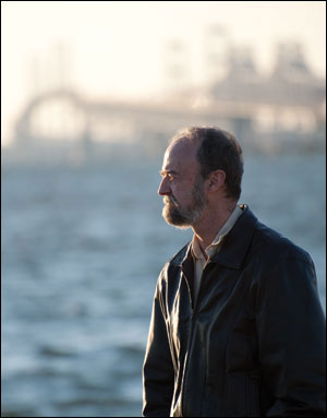
Jeff Halka of the Maryland Geological Survey helped lead a search for ancient channels that could be buried under the bottom of the Bay. The first evidence for paleochannels came from boreholes drilled for the building of the Chesapeake Bay Bridge. What Halka and his collaborators found changed our understanding of how the Chesapeake Bay was created. Credit: Michael W. Fincham.
"How did the Chesapeake Bay get here? How did it come to be?"
HE WAS READING THE HUNT FOR RED OCTOBER at work that September, and his job was leaving him time to devour long novels about Russian submarines. He was spending his work days on a 51-foot research boat that was creeping back and forth across the Chesapeake Bay at four knots. In a hot cabin, sealed tight to keep out the flies, he monitored two printers that were plotting out acoustic profiles for everything passing under the boat. Towed behind the stern, two sleds of noisemakers were shooting clicks and clacks down at the bottom.
The sound waves could detect any schools of fish passing by or ping on any Russian submarines that managed to sneak past all the Navy ships down in Norfolk and slide up the deep mainstem channel of the Bay. Jeff Halka, however, was a geologist, and he wasn't hunting fish or submarines.
The year was 1985, Halka was 35 years old, the Cold War was 40 years old, and the Chesapeake Bay, up here in Maryland waters, was about 6,000 years old. Trim, brown-haired, and bearded, Halka was using sound waves to search deep below the bottom of the Bay for something much older: the ancient channels buried there long before human beings formed nations and went to war. He was looking for the ghosts of other, earlier Chesapeake Bays.
The current Chesapeake, according to geologists, is the drowned valley of the Susquehanna, the great river at the head of the Bay that pours in nearly 50 percent of the river water entering the estuary. During the depths of the last ice age, the Susquehanna flowed south, then east across the dry, exposed plateau of the continental shelf before emptying into a distant Atlantic Ocean. When the glaciers began shrinking some 18,000 years ago, sea level began rising, sweeping back across the plains of the continental shelf. About 10,000 years ago, the ocean reached the area we now call Norfolk, and seawater began flooding up the valley of the Susquehanna, turning the lower reaches of the river into an estuary.
An estuary like the Chesapeake is neither ocean nor river — but something else: an ecosystem that mixes fresh- and saltwater, creating wetlands and water bottoms, food webs and biological communities found nowhere else. By 3,000 years ago, the Chesapeake estuary had stretched 190 miles north of Norfolk, pushing the mouth of the Susquehanna River all the way up to Havre de Grace, Maryland.
This image of a "drowned river valley" has been widely accepted for 80 years as the creation story for Chesapeake Bay, but like evolution theory and big bang theory and other big-picture origin stories, it leaves some important questions unanswered. If, for example, the end of the last ice age created the current estuary, then what happened when other ice ages flourished and faded? As earlier glaciers melted, sea levels must have risen then also, flooding earlier river valleys. If so, where were those earlier river channels?
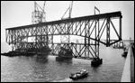
For 30 years, bits and pieces of old channels had been turning up, mostly under bridge pilings. Some of the first bits came with the building of the Chesapeake Bay Bridge, the long-delayed structure that would finally link the mainland of Maryland more easily with its Eastern Shore counties along the Delmarva Peninsula. When engineers in search of firm footing drilled boreholes across the Bay in 1948, they hit coarse river gravel 120 feet down, uncovering the first evidence that an ancient river valley was buried beneath the Bay. Chunks of other channels came from other bridge sites, from well-drilling logs, and from several short research cruises.
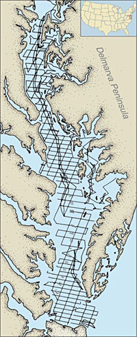
But no one ever tried to connect all these scattered dots until Halka teamed up with Steve Colman of the U.S. Geological Survey and Carl Hobbs of the Virginia Institute of Marine Science. They launched a series of boat surveys designed to cover the entire mainstem of the estuary, with Halka running two cruises in Maryland waters, and Hobbs running two in Virginia waters. Each two-week cruise covered 25 percent of the Bay. Four cruises covered the entire Bay — all in hopes of uncovering any ghost channels and tracing out their ancient pathways through earlier estuaries.
AN ESTUARY IS NEITHER ocean nor river, but a blending of both. According to one classic definition, it's a semi-enclosed body of water, open to the sea, where salty water from the ocean mixes with freshwater from the land.
That definition dates from 1952 and came from Don Pritchard, the first professional oceanographer to study the physics of Chesapeake Bay. It's a definition that has weathered the passing decades and the alternate definitions proposed by later scientists, largely because it captures the essential element, the mixing of fresh and salt, from which so many other estuarine features flow. more . . .
Their survey would be the first Baywide search for these old channels — and probably the last. In this current era of funding cutbacks and practical research goals, their quest now seems almost quixotic. Men and boats and gear, all committed to finding channels that disappeared tens of thousands, even hundreds of thousands of years ago. Geologists on a small boat in the middle of a bay probing down through dark waters — think of astronomers in an observatory on top of a mountain peering up into the night sky, looking back in time toward the edge of the universe.
How did this universe begin? How did this estuary begin? Questions about origins are always compelling — indeed humans seem programmed to keep asking origin questions and writing origin narratives. Geologists, when they are not looking for oil and gas or minerals, seem even more programmed than other scientists to tackle these issues. "How did the Chesapeake Bay get here?" says Halka. "That was my interest: how did it come to be?" By the time Halka, Colman, and Hobbs finished their Baywide expeditions, they would be ready to write a new, unexpected origin story about the creation of today's Chesapeake Bay.
Is there, however, any practical value to this kind of old-fashioned basic research? Does (really) ancient history have anything to tell us about current struggles to save Chesapeake Bay? Does the past have anything to tell us about the future?
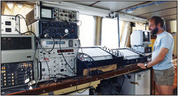
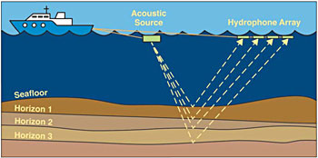
A basic array for creating an acoustic profile includes a boat, a towable noisemaker that shoots sound waves, towable hydrophones that catch the echoes, and then on-board recording gear that translates the echoes into data. Seismic profilers use low-frequency sound waves that reflect off the bottom but then keep penetrating deeper, sending echoes back from each density layer they encounter. The lower the frequency, the deeper the echo. Steve Colman of the U.S. Geological Survey monitors on-board data-recording gear. On his left: two printers sitting atop exhaust fans; then power supplies, including amps and receiver; and stacked above, more electronic gear, including LORAN and an oscilloscope to monitor the acoustic signals. The map (below) shows the survey grid the boat followed: a back-and-forth, up-and-down crosshatching of the mainstem of the Chesapeake. Photograph courtesy of the U.S. Geological Survey; map adapted from Figure 1 in Colman et al. (1990); boat schematic adapted from a figure by Jeff Halka.
ON SEPTEMBER 28, 1985, JEFF HALKA BEGAN HIS PART OF the search by motoring out of Solomons Island on a research boat so loaded up with high-voltage electrical gear that anybody on board could feel at least a little nervous. The 51-foot RV Discovery carried in its cockpit a massive generator for firing off voltage charges, two sets of towable noisemakers, a rack of amplifiers and receivers, and two printers with exhaust fans. With all the electronics sitting on board or dragging through the water, everyone would be keeping an eye on the weather.
September in Maryland is still hurricane season, and Halka and his crew were launching just one day after Hurricane Gloria had swept up the coastline, dumping heavy rains and tearing up boardwalks in Ocean City. September is also the tail end of thunderstorm season, and their real worry was the dark thunderheads that often come towering out of the west, crackling with lightning that's looking for a strike point.
Riding with Halka was Steve Colman, also brown-haired and brown-bearded, but with an early receding hairline. A key player in setting up the search, Colman worked for the U.S. Geological Survey, and he brought funding, equipment, and staff support from the Survey's Woods Hole office. After Halka and Hobbs arranged boats for the Maryland and Virginia surveys, the three geologists worked out an extensive search plan. They would scour the entire Bay bottom with sound waves that penetrate the Bay floor and use the echoes to profile the sediment levels that lay beneath. The boats would run long transects, back and forth, crawling east and west, then north and south, in effect, creating a grid, crosshatching the Bay (see map to the right) with seismic probes.
For seismic profiling they were carrying two towable noisemakers aboard the RV Discovery. From the Maryland Geological Survey, Halka brought a transducer that could fire off four clicks a minute. From the U.S. Geological Survey, Colman brought a boomer that could bang off louder claps at the same rate. Widely used in seismic searches for underwater oil and gas, the boomer works by bashing two metal plates together to create a rapid series of claps or pressure waves.
Once on station, the RV Discovery slowed to four knots, the captain started running a transect, and the work day fell into a familiar rhythm. He watched for crab pots, the noisemakers clicked and clapped, the plotters traced out profiles of the bottom. In the cabin Halka and Colman could hear the echoes coming back toward the hull: a small sound comes off soft mud, something louder from hard bottom. In tee shirts and shorts they were spending most of their time on the endless bookkeeping of data taking: tracking the course, making notes on data sheets and nautical charts, changing reels in the tape recorders, changing paper in the plotter, changing the stylus in the plotter.
The two-week cruise fell into its rhythm. The boat would creep across the Bay, the plotter would inch across the paper. Running long, slow transects in a crosshatch grid was always boring work. Boat crews called it "mowing the lawn," and drank lots of coffee to stay awake. Dusk would bring a dock, a nice marina, a nearby bar (a bar could be a necessity). Then a motel bed and more reading before sleep. Waking before dawn in Solomons Island or Tilghman Island, in Cambridge or Crisfield, everyone had to grab a quick breakfast, then head out again in the early light.
Crabs pots and thunderstorms were problems. Pots would catch on the sleds or the hydrophones where they would hang up and drag and mess up the data flow. Thunderstorms meant a run for harbor and a short day. A lightning strike could fry a lot of electronics, scare a couple of scientists, and end the whole cruise.
The plotter was the big problem. It was the end point in the data chain, the raison d'etre for all the boat work, and it would go funky. To create the data record, it used three-layer paper with a carbon midsection. A stylus burned through the top layer, exposing the carbon layer and spewing burnt carbon dust into the cabin. As long as the exhaust fans were working and the windows were open, life was bearable. When the flies came out, mostly along the Eastern Shore, and the windows were shut, and the fans broke down, then life would stink. Dust filled the cabin smelling like ozone and burning hair. Everyone hustled to fix the fans, some got seasick, no one ever forgot the stench.
Amidst the drudgery: sudden discoveries. Leaning over the plotter, Halka and Colman could see an ancient channel take shape before their eyes. On the plot, a slice of buried channel looked like the skeleton of a sunken ship filled with sediment. First a downslant, then a leveling out, then a curving back up. A bow, then a keel, then a stern. What looked like a ship was actually the outline of a river bank, a channel bottom, a far shore. A ghost image from a long-ago Chesapeake.
 Baltimore Sun Media Group. Baltimore Sun Media Group.
All rights reserved
IN 1938, A LINE OF TEST BOREHOLES was drilled across Chesapeake Bay between Sandy Point and Kent Island in hopes that a bridge (or possibly a tunnel) might finally be erected that could link the Maryland mainland and its Eastern Shore counties with something faster than steamboats and ferries.
A funny thing happened on the way to the Eastern Shore: geologists discovered evidence of an older Chesapeake buried beneath the Bay.more . . .
Each glimpse into the past was quickly gone. The boat plodded on, tracking along its appointed transect. Nobody broke the grid to give chase and track down the rest of the channel. On the next pass back across the Bay they cut across a second slice of the channel. The third pass cut another slice. The fourth pass, another slice. The grid was all. The slices would add up, the channel track would take shape.
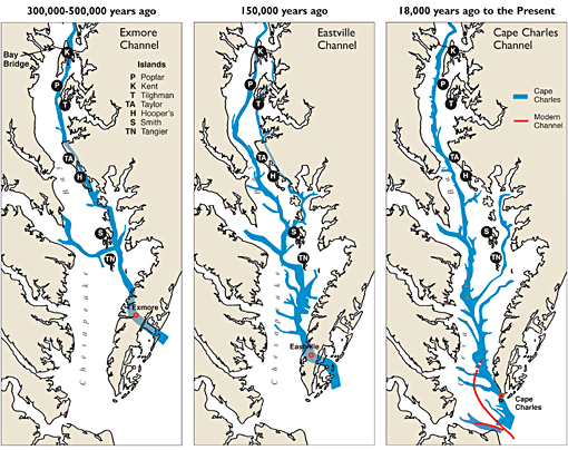
IN THEIR DATA SEVERAL TRACKS of buried rivers would take shape. Piecing the slices together, Halka, Colman, and Hobbs would discover three paleochannels of the ancestral Susquehanna hidden beneath the Bay.
In his office at the Maryland Geological Survey, Jeff Halka unrolls strips of plotter paper and spreads them out on a long table so he can show me the seismic profiles from 1985. Halka is older now, but still trim and fit-looking with receding hair and graying beard. Leaning over his data sheets, he explains the new findings — and the new questions — that emerged from all those long days on slow-moving boats.
Geology Below the Bay
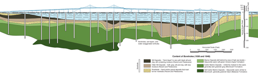
To find the best locations for the bridge's foundation, engineers drilled a series of boreholes. The coring logs, which included detailed descriptions of the color and texture of sediments at different levels, provided geologists with information valuable in mapping out the channels of ancient estuaries. This illustration shows an approximation of how the boreholes from 1938 and 1948 and the underground cross section of soil layers they revealed line up with the above-the-water bridge. The layer with small dots indicates sand and gravel — for geologists the sign of a riverbed. This deposit clearly outlines the sides and bottoms of buried river channels. The deepest channel runs well to the east of the center span of the bridge. Geologists believe it is the paleochannel of the Susquehanna River Valley as it was some 18,000 years ago. Named the Cape Charles Channel (see Three Ancient Estuaries), it runs all the way to the mouth of Chesapeake Bay. To the west of the deep channel is a shallower paleochannel beneath the center span of the bridge. This channel could be a tributary, perhaps the Patapsco River, which may have flowed through here on its way to hook up with the Susquehanna. Illustrations adapted from drawings in the Chesapeake Bay Bridge engineering report (J.E. Grainer 1948).
Three Susquehanna Rivers ran to the sea during three earlier ice ages, he says, and with rising sea levels each became a drowned river estuary much like the current Chesapeake. One paleochannel is about 18,000 years old, a second, older paleochannel dates to 150,000 years ago, and the oldest — and most difficult to date — is 300,000 to 500,000 years old.
Other discoveries followed, raising tricky questions. As each new Susquehanna River formed, it created a new course. Instead of stacking itself on top of an older channel, the new river would shift course. Why the shift? "If we have these different channels that are all in different locations," answers Halka. "That implies the Chesapeake had to fill in with sediments."
But the new river locations were, for the most part, always to the west. And the new mouth of the Chesapeake was always farther south. Why west and south? What was shoving these channels around?
He points at the pale charcoal image of a buried river. "You can see where you've got an old fluvial channel here," he says. "Flat bottom with the walls on both sides." The river channel he's showing me was probably carved out by the Susquehanna River some 300,000 to 500,000 years ago. When that ice age ended and global warming began shrinking the glaciers, the river would roar toward the sea, swollen with meltwater, carving a deep valley in its path.
Those river torrents were heavy with sediment, including loose gravel washed off bare land long buried under a thick ice sheet. This hard gravel would form the riverbeds found in the Bay Bridge cores and in Halka's seismic profiles.
As rising sea levels began invading the valley, the river turned into an estuary, a natural sediment trap. Wherever the river met a daily tide of incoming seawater, it began dropping its sediment load. The deep channel filled up. The estuary began to flatten out.
Halka points to the profile of the filled-in channel. "The deep channel is gone," he says. "Some sort of meandering, tidal, marshy river is making its way to the sea." What was the final fate of this earlier Chesapeake? "You may have had a wide, shallow, flat Bay."
What did a flat estuary mean for the next Chesapeake? When another ice age arrived, it drew sea levels down, draining seawater out of the estuary. With the old channel now clogged up, freshwater was free to find another way to run to the sea. Water could flow and meander into nearby streams or furrows, and when one of those streams began to carve a deeper channel, other streams were drawn in. Unimpeded by the tide, the new river was unstoppable now: it ran stronger toward a faraway ocean, digging out a deeper channel, carving a new valley.
But why does each new river, each new Chesapeake, set up farther to the west? This is one of the puzzles that emerge from the maps that Halka and his collaborators piece together. The oldest paleochannel is the easternmost. The Exmore Channel (300,000 to 500,000 years old) held a Susquehanna River that ran where parts of the Eastern Shore now stand. Kent Island, Poplar Island, Taylor Island, and Hooper's Island are all parked atop the buried track of this oldest river channel. This early Susquehanna even flowed east of Smith Island and Tangier Island. Watermen now motoring out to their crab pots may not realize their home sites once stood west of the Chesapeake.
With the next channel, the pattern emerges. The Eastville Channel (150,000 years old) ran mostly to the west of the older Exmore Channel. And the youngest channel, the Cape Charles Channel (18,000 years old) stayed mostly to the west of both earlier channels.
Another puzzle emerges. As each ancient river shifted west, each one pushed the mouth of the Chesapeake farther south. In Virginia waters the surveys were run by Colman and Carl Hobbs from VIMS, but the channels they were tracking went where no boat could follow. Motoring back and forth across the southern Chesapeake, Hobbs and Colman would eventually lose track of the Exmore and the Eastville channels. One by one they disappeared under Virginia's Eastern Shore, leaving the geologists to guess at where the old channels went next and where they met the ocean.
GUESSES ARE BIG IN SCIENCE (they're usually called hypotheses) — but sometimes luck is bigger.
Before Halka and his collaborators began their boat surveys, Robert Mixon was already drilling deep boreholes in the lower reaches of the Delmarva Peninsula. A land-based researcher with the U.S. Geological Survey, Mixon was trying to figure out the underlying geology of the Delmarva Peninsula, that long skinny landmass that separates the Chesapeake Bay from the Atlantic Ocean. Stretching 183 miles in all, the peninsula now holds all of Delaware and the Eastern Shore sections of Maryland and Virginia.
It was Mixon who provided the luck. When cores from two of his boreholes showed coarse river-bed gravel, Mixon speculated that some long-ago rivers once ran there. He published his findings in 1985, about the time Halka, Colman, and Hobbs were beginning their boat surveys of the Chesapeake.
Three Ancient Estuaries
Three ancient channels lie buried beneath the modern-day Chesapeake Bay, each one named for the town or cape near where it once exited to the ocean.
Exmore Channel. This is the oldest buried paleochannel of the Susquehanna River. Running under Kent Island, Poplar Island, and Hooper’s Island, it tracks to the east of Smith and Tangier islands. It then crosses under the Delmarva Peninsula. When the channel was an active river, it was fed by the Patuxent and the Potomac rivers. It formed the southern end of the Delmarva.
Eastville Channel. This channel has a track that is shifted to the west for most of its run, though it swings west and east more wildly than the other channels. It also runs under part of Kent Island, and it crosses the Delmarva farther south. As an active river it was fed by the Rappahannock River, and for a time it formed the tip of the Delmarva.
Cape Charles Channel. This channel is shifted still farther west again. It was the axial channel of the Susquehanna River when rising sea levels began turning the river into our current Chesapeake Bay. Its track runs near the modern deep channel. As a river, it captured all the western shore rivers except the James. Once 160 feet deep at the mouth of the Chesapeake, the channel was quickly buried under Fisherman’s Island by sand and sediment from the sea. Maps and channels redrawn from Figure 8 in Colman et al. (1990).
It was Steve Colman who provided the guesswork. He looked at where his paleochannels disappeared under the peninsula, and he looked at where Mixon had found river gravel. Then he made some guesses and began drawing dotted lines from his channels to Mixon's boreholes. His oldest paleochannel lined up with a borehole near Exmore, Virginia, a small town on the lower Eastern Shore. Another paleochannel lined up with a borehole near Eastville, nearly 20 miles farther south. "We could trace the river channels through the Bay and project them right across the Delmarva Peninsula and right through where his drillholes went," explains Colman, speaking by phone from his office in Duluth, Minnesota, where he now runs the Large Lakes Observatory.
Guesswork plus luck brought a breakthrough for both research teams. The land-based work completed the water-based work. And vice-versa. Now Halka, Colman, and Hobbs could name their buried channels and map where they entered the ocean. And Mixon could see where his river gravel came from. By mapping the river channels down the Bay and drawing their paths across the Delmarva and right through the boreholes, the geologists could finally connect all the dots. "We could put [the channels and the boreholes] in a sequence of time," says Colman, "and relate them to the rest of the Bay."
Evolution of the Delmarva Peninsula
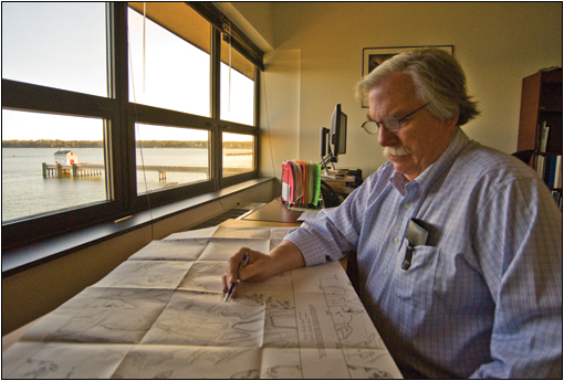
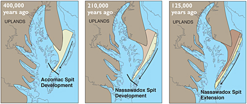
Carl "Woody" Hobbs organized the boat surveys that searched the lower Bay for buried paleochannels. From his office at the Virginia Institute of Marine Science, he can look out his window past the mouth of the York River and see the Eastern Shore of Virginia, which forms the lower part of the Delmarva Peninsula. During earlier versions of Chesapeake Bay, however, he would have had an ocean-front view. The Delmarva Peninsula took its time getting here — a lot of time, in fact. It stretched south in steps, according to research by Robert Mixon of the U.S. Geological Survey. It began as a spit of land, but grew longer during eras of rising sea levels when longshore ocean currents piled sand and sediment onto its southern tip. By forcing future channels farther west and south, the Delmarva became a force in the slow shaping of today's Chesapeake Bay. Photograph by Michael W. Fincham.; maps adapted from figures in Hobbs (2004).
Mixon's findings helped solve several puzzles. Why did these ancient channels keep shifting to the west? And why did the mouth of the Bay keep shifting to the south? Because the Delmarva Peninsula, according to Mixon, kept growing southwards in steps. As it grew fatter, it forced river channels to the west. As it grew longer, it forced each river to exit farther south.
The Delmarva, it turns out, was the secret shaper of Chesapeake Bay. Though the peninsula began as a short spit of land, it was a spit susceptible to great growth spurts — and great growth pauses. It grew with rising sea levels, and it paused with falling sea levels. When warm eras brought rising seas, ocean currents would pile up sand and sediment — extending the southern end of the spit. As the river at the end of the spit became an estuary, it filled up — and the Delmarva spit simply extended itself right across the flat channel. The peninsula buried the Exmore Channel first, then it buried the Eastville.
The Delmarva Peninsula drove the shaping of today's Chesapeake Bay.
Each growth spurt ended in an ice age: falling sea levels drained the ocean away, terminating sand deliveries, and exposing the Delmarva as a long, low hill along the empty, dry plains of the continental shelf.
The Delmarva and the Susquehanna were caught up in a slow-moving dance, a dance to the music of time where each partner took turns taking the lead. During ice ages and early icemelt, the Susquehanna took the lead, carving a new river valley out to a faraway ocean while the Delmarva sat unmoving. During sea level rises, the peninsula took big steps, pushing its dance partner farther south.
The shift to the south can be seen on any contemporary map (see pp. 10-11). Pick out the small town of Exmore, Virginia: it sits 40 miles north of the Bay mouth. Locate Eastville: it sits 21 miles north. Find the tip of Cape Charles, just north of Fisherman's Island: the cape lies 8 miles north of the active tidal channel. Each marks a spot where the Chesapeake channel once met the sea.
The speed of change can be seen in snapshot form at the mouth of today's Chesapeake. When the rising ocean reached the Norfolk area some 10,000 years ago, the Susquehanna ran through the Cape Charles Channel. As the sea began to flood in and drown the river, shaping today's Chesapeake, it also began burying the Cape Charles Channel. Sand came sweeping down the ocean side of the Delmarva Peninsula, carried by a south-flowing longshore current. At the mouth of the Bay, the longshore current meets the tidal currents entering the Chesapeake, and the flood tides for the Bay start sucking in water and sediment like a giant vacuum cleaner roaring at full power.
The Cape Charles Channel never had a chance, filling in rapidly. "Not only was the channel 160 feet deep," says Halka, pointing at Fisherman's Island, a barrier island just off the southern tip of the Delmarva Peninsula. "But the channel has completely filled with sediment — and we've got an island sitting on top of it."
WITH THEIR FINDINGS, THEIR GUESSES, and their good luck, Halka, Colman, and Hobbs were able to rewrite the classic creation story for Chesapeake Bay. The long-accepted story of a "drowned river-valley estuary" was still useful, according to Colman but only as "a first approximation." The new narrative would complicate the story, adding unexpected plot points, and it would revamp our understanding of the deep history of Chesapeake Bay.
The new story spelled out the fate of earlier estuaries: they all filled in and flattened out. And it included the evidence: the corpses of three paleochannels. It also introduced powerful new players in this long-running geological drama, players like the Delmarva Peninsula and the sand-carrying ocean currents that built it. "Nobody had a synthesis of how the paleochannels related to the land forms," explains Hobbs.
In the new synthesis, the Delmarva drove the shaping of today's Chesapeake by constantly forcing rivers to the west and to the south. And shaping this landmass were longshore currents and flood tides, the unstoppable engine that carried in sand, built the Delmarva, and buried one southern Bay channel after another. That engine is still running: it is currently building shoals right across the mouth of the Bay and has even sent sand as far north as Tangier Island up near the Maryland line.
"Everybody knew that an estuary like the Chesapeake is an efficient trap for sediments from all sources," says Halka. "But I don't think anybody recognized the degree to which the ocean factors in."
The new origin story is not a finished story, but it sets the template for future research to fill in. A fourth paleochannel between the Exmore and Eastville channels has been proposed, based on new boreholes. And other, earlier channels may lie completely buried under the Eastern Shore where boat sampling could never locate them. An ancient paleochannel serves as the groundwater supply for Salisbury, Maryland, but where it originated remains a mystery. Tracing that channel back to Chesapeake Bay or Delaware Bay would be too expensive, requiring land-based boreholes and seismic sampling techniques that are usually reserved for locating gas and oil.

THE GHOST CHANNELS THAT JEFF HALKA helped find some 25 years ago have now come back to haunt him.
The year is 2011, the Cold War is over, the Chesapeake Bay is older, and last year Jeff Halka became director of the Maryland Geological Survey. The job gets him the corner office with large windows and a lot of wooden bookshelves, but it doesn't leave him much time anymore for exploring big-picture stories about the shaping of Chesapeake Bay.
The current work list for his agency is clogged with highly practical issues like groundwater supplies around the state, shale gas deposits in Western Maryland, salt-water intrusion on the Eastern Shore, shoreline erosion, and buried oyster beds. One never-ending problem is familiar: sediments keep filling today's shipping channels the way they once filled those long-ago ghost channels.
What ships, after all, will sail to Baltimore through a filled-up channel and a flattened estuary? Ships already have to pass through 11 man-made channels to sail up the Bay. Near the mouth the channels are filling with sand from the ocean. Near Baltimore they are filling with sediment from the land. When these deposits are dredged out of those channels, Halka helps figure out where to put them. As part of his job, he works with the Port of Baltimore on their 20-year dredge spoil management plan.
It's clear from the ghost channels, however, that the port of Baltimore will also need a 200-year management plan, even a 2,000-year management plan. The message from his ghost channels is unambiguous and highly practical. The problem of the ship channels will never go away. When it comes to dredging, says Halka, "We are never going to be able to stop."
It seems the ghost channels have a lot to say about today's estuary. Sediment runoff, unfortunately, does more than fill in shipping channels. It also darkens the Bay, cuts off sunlight, kills off seagrasses, and buries oyster beds. As a result, controlling sediments has become a high priority in the current campaign to restore or at least preserve Chesapeake Bay. Farmers are trying contour plowing, no-till agriculture, winter cover crops, and buffer zones. Home builders and highway engineers are using hay bales and sediment ponds. Cities and towns are looking for new ways to control stormwater runoff. Environmentalists are planting trees and living shorelines and seagrasses.
The list goes on. And the work goes on. And if the work ever stops, the river channel will fill up, the estuary will flatten out, and the Bay mouth will narrow down. We won't need a high-arching bridge to reach the Eastern Shore, just a causeway for driving or a pair of waders for walking.
|