|
When a Slow, Lazy River Is a Cleaner River
Jeffrey Brainard
Scientists and engineers say much remains
to be learned about how well restored streams
help to improve water quality.
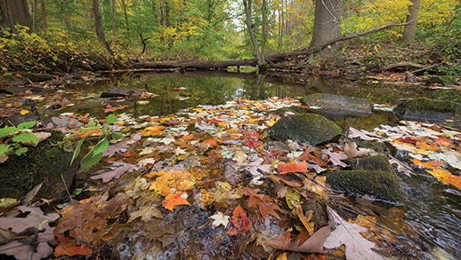
White Clay Creek in rural southeastern Pennsylvania has been designated a wild and scenic river. It is also the site of a long-term research study, conducted by the Stroud Water Research Center and funded by the National Science Foundation, about the effects of stream restoration. Photograph, David Harp
YOU CAN WALK JUST A FEW STEPS OFF ROUTE 2, away from the cars steadily rumbling by the busy Severna Park Marketplace shopping center, and enter a peaceful-looking landscape. Tucked away in this suburban corner of Anne Arundel County, a stream meanders through a series of wide pools. A pair of Canada geese are sunning themselves as a blue heron flaps overhead. But the stream didn't always look that way. In 2012, it received the riverine equivalent of an extreme makeover.
North Cypress Branch had been identified by the county government as one of Anne Arundel's most degraded streams. Stormwater that drained into it had eaten away at its channel, leaving bare banks and exposing the roots of nearby trees.
The makeover began when contractors arrived to cut down trees along the stream, a sight which troubled some neighbors. After the tree cutters left, the bulldozers came next, maneuvering in and around the narrow channel. Contractors worked to change the stream channel so that it would function differently. Workers widened it to 50 yards in places and carved out a series of shallow, landscaped pools spaced along gentle contours stretching a half-mile. The project, completed in 2013, cost $1.7 million.
The point of this work was to slow the flow of water that sped through North Cypress Branch during and after storms. That could help reduce erosion and remove some of the pollutants carried downstream to the Magothy River and, eventually, the mainstem of the Chesapeake Bay. In the estuary, the pollutants — excess sediments and nitrogen and phosphorus — combine to degrade water quality, reduce the range of underwater grasses to shallow waters, and in deeper waters create dead zones of no oxygen that stress fish populations.
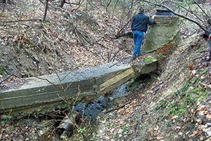
Rushing stormwater had eroded a stream called Milkhouse Run in Washington, D.C.'s Rock Creek Park, exposing a sewer pipe and carrying soil downstream (above). In 2011, engineers reworked the stream channel, installing shallow pools, weirs, and native vegetation to slow water flow and reduce erosion (below). This type of restoration design is called a regenerative stormwater conveyance. Photographs, Biohabitats Inc.
One of those watching the North Cypress restoration work was Solange Filoso. She is a watershed scientist at the Chesapeake Biological Lab, part of University of Maryland Center for Environmental Science (UMCES), who studies stream restoration, currently a much-debated topic in the multi-state master plan for improving water quality in the Chesapeake Bay. Filoso has been monitoring the water-quality effects of the North Cypress project for the county. Her monitoring began too recently to report results, but she says her findings suggest that other stream restorations may offer only modest reductions in the flow of nitrogen downstream. Restorations may, however, provide other benefits.
Lessons learned from one stream can be applied in others. Governments around the region are considering stream restoration as a way to comply with federal regulations calling for reduced pollution in the Chesapeake.
But to what extent stream restoration can improve water quality is a question that Filoso and a number of other scientists are working to quantify. The science of stream restoration is fairly young, only about two decades old. As research has begun to provide answers, new questions have arisen.
To Filoso, what's clear today is that a project like North Cypress turns a stream into something else. "Streams are being modified, sometimes dramatically, to the point that they are functioning as combinations of streams and wetlands," she says. Removing trees along stream channels, for example, may change how organic matter and nutrients are processed in the stream. "There are pros, cons, and trade-offs in restoration," Filoso says. "We still need to fully understand them."
Maryland's Degraded Streams
Maryland has a lot of freshwater, non-tidal streams and rivers — more than 19,000 miles. And many streams in Maryland, and throughout the Chesapeake watershed, are in bad shape. The Maryland Department of the Environment issues a biennial report about the state's waterways and their compliance with federal water-quality regulations. In 2014 the department estimated that about half of the state's stream and river miles violated at least one of the water-quality standards — for example, to support healthy populations of fish and other aquatic life.
Many of the streams not meeting standards are located in built-up areas: metropolitan Baltimore, Washington, D.C., and other populated, urban areas of the Chesapeake watershed. Major culprits affecting stream water quality include the houses, malls, roads, and parking lots of modern life. Their hard surfaces prevent rainwater from percolating into the ground. Instead, the buildings and concrete funnel stormwater through drainage pipes and ditches and then into streams.
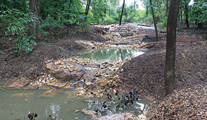
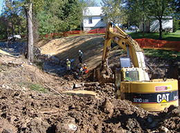
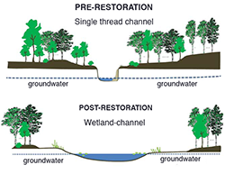
A construction crew uses heavy equipment in the channel of Jennifer Branch, Baltimore County, to rework its shape and function (photograph). Rushing stormwater can erode unrestored stream channels until they become narrow and deep (top illustration). Some stream restorations widen stream channels to make them shallower (bottom illustration) to slow stream flow and reduce erosion. These changes also create more contact between the stream water and groundwater, which increases the removal of nitrogen. Photograph, Biohabitats Inc.; illustration, Solange Filoso, University of Maryland Center for Environmental Science (UMCES)
Much of this runoff is laden with sediments, nitrogen, and phosphorus from a variety of sources in the Chesapeake's drainage area, or watershed. Leaking sewer systems release nitrogen and phosphorus, for example; clearing land for parking lots sends sediments downstream. As water rushes through networks of streams, the runoff eats away at stream channels and banks, washing more sediments and nutrients downstream. Some stream ecologists use the term "hot, fast, and dirty" to describe not some off-color movie but the conditions of many Maryland streams after summer thunderstorms.
Improving this water quality is one reason that the Chesapeake Bay watershed has hosted the highest concentration of stream restoration projects in the nation. According to a 2005 study more than 4,700 projects cost $400 million from 1990 to 2003. Maryland alone had more than 2,300 such projects.
Now Maryland officials are planning more of these projects to help comply with mandatory federal targets for water quality that took effect in 2010. These targets are called the Total Maximum Daily Loads or TMDLs. To meet those requirements, Maryland counties proposed restoring some 410 miles of streams by 2025, in plans they submitted to the Chesapeake Bay Program. That is far more than any other of the six states in the Bay's watershed that are working to meet the TMDLs. Those 410 miles of stream restoration projects represent two-thirds of the total mileage of such projects planned in the entire watershed. The point of these projects is to try to convert these beat-up streams into assets to help the Bay.
Estimating the Reductions
So does improving a stream in Baltimore or Howard County or Pennsylvania help to improve water quality in the Bay? And if so by how much?
In 2011, the Chesapeake Bay Program asked an advisory panel to address those questions by reviewing the latest available science. The panel included state and local environmental officials, restoration contractors, and academic scientists. Knowing the answer could allow the Bay program managers to estimate with greater accuracy the contribution that each mile of restored stream makes toward meeting the TMDL targets.
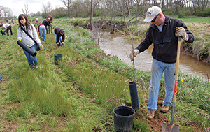
Volunteers plant trees beside Tuscarora Creek in Frederick County in 2009. Healthy streams are commonly surrounded by forested areas called riparian zones, and many restoration projects work to establish such zones. Planting trees and other vegetation improves the stream's water quality. The plants reduce excess sediments and nutrients flowing from the stream's upland drainage area into the stream channel. Photograph, Chesapeake Bay Foundation
The panel offered some answers in a 151-page report that received approval from the Chesapeake Bay Program in September 2014. The report highlighted the challenges of stream restoration but also described new studies that the panel said provided encouraging signs that restoration could make a meaningful impact on water quality. Evidence from Maryland and southeast Pennsylvania indicated that erosion of stream channels loaded more than 10 times the amount of nutrients and sediments into the stream water than was estimated only a decade ago. That suggested, the panel said, that stream restoration projects that reduced erosion could improve water quality more than was previously thought.
The report offered a set of methods for figuring how much reduction in nutrients and sediments could be chalked up to stream restoration projects. These methods represent the first such methodology approved in the United States to inform a set of TMDL targets. Counties may now use the methods to document that stream restoration projects are helping them to meet their TMDL targets.
But improvements in water quality shouldn't be the only goal of stream restoration projects, the panel added. It said these projects should also improve the biological quality of stream habitats, which is measured through indicators like the presence of certain species of fish and aquatic insects.
Accomplishing both of those goals is a challenge because "major scientific gaps still exist to our understanding of urban and non-urban stream restoration," the panel acknowledged. One such gap is that effects on water quality vary according to the restoration designs and methods chosen and a stream's location and size. To account for these differences, the panel's methods of estimating results included several stream-engineering techniques and offered ways to adjust the estimates to reflect conditions in individual streams.
Slower Currents Are Key
Broadly, the engineering techniques studied by the panel are variations on a single theme: they slow down the stream's flow. This reduces the energy of the water and its tendency to eat away at stream channels. A slower current, combined with other features of a stream restoration project, can help to remove excess nitrogen from the water and trap sediments. Putting the brakes on sediments also helps to restrain the downstream flow of phosphorus, which can attach to sediments.
One method for slowing down the water and protecting channels uses "natural channel design." This type of design transforms an eroded stream channel — which can look like a straight, box-shaped chute — into something that looks more natural: a stream dotted with rocks, boulders, and meandering curves. The channel's path is broken up by weirs, lines of stones called cross-vanes, and tree trunks.
Baltimore City and Baltimore County have carried out several of these projects at sites like Stony Run, which winds through Roland Park to the Inner Harbor. In 2010, the city completed a $10-million project to restore the stream and improve sewer and stormwater systems around it. The stream is now part of a park and trail system.
Despite the popularity of these projects, there is a long-running debate about whether this approach, sometimes described as "armoring" the stream channel, reliably reduces erosion and by how much.
The inventor and chief proponent of this approach, Dave Rosgen, a charismatic stream restoration consultant working in the western United States, developed a method of estimating erosion rates. His approach compares the stream with others that have similar characteristics like width, depth, and shape — and that have documented rates of erosion.
Peter Wilcock, now head of watershed sciences at Utah State University, was a professor at the Johns Hopkins University until 2014, and he takes issue with how Rosgen's approach has been applied in Maryland. For example, he says, it tends to identify streams as rapidly eroding because they have tall, bare banks. Some of these streams are indeed eroding, but others stopped eroding years ago and have remained stable since. "Bank erosion is too complex, too episodic, and controlled by too many factors to predict its rate based on the presence of bare banks," Wilcock says.
He says that to reliably measure erosion rates and pick which streams need restoration most, a different approach is required: you have to examine historical data. Old aerial photographs and land surveys can show observable signs of erosion over time. In its final report, the advisory panel on stream restoration endorsed using Rosgen's methods as one way to estimate sediment reductions. But the group also recommended using Wilcock's approach for confirming those estimates.
Once such restoration projects are completed, though, there's a lack of evidence about their effects, wrote Rebecca Lave, a geographer at Indiana University who analyzed Rosgen's methods in an article in the Journal of the American Water Resources Association. Funding for monitoring has been poor, she says, so "we in the stream restoration world are currently in the untenable position of spending more than a billion dollars of taxpayer money a year on restoration projects with no real idea of whether or not they are succeeding."
Removing the Nitrogen
Another kind of stream restoration design also slows the flow: it spreads it out. This approach creates a wider, shallower stream channel, like the one created at North Cypress Branch. When it rains and the flow rises higher in the channel, more water can move into adjacent side channels and wetlands.
The purpose of this widening and spreading is not only to reduce erosion but also help cleanse the stream of excess nitrogen. Increasing contact between the stream's water and the land in and around the channel can, under certain circumstances, increase an important biological activity called denitrification.
In this process, bacteria convert a molecule called nitrate (or NO3-, because it has one nitrogen atom and three of oxygen) into nitrogen gas (N2). Once created, the nitrogen gas escapes from the stream into the atmosphere, reducing nitrogen levels in the stream and improving water quality. In a way, these streams are acting like nature's kidneys.
But scientists have also discovered that it can be a challenge to measure how much nitrogen is removed, and under what conditions — information that could inform our understanding of stream restoration's usefulness as a tool in the Bay cleanup effort.
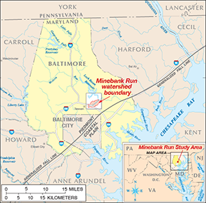
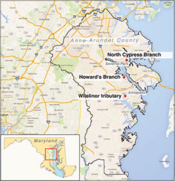
One scientist who has worked to find answers for those questions is Sujay Kaushal, an aquatic ecologist at the University of Maryland at College Park. Kaushal served on the Chesapeake Bay Program's advisory panel on stream restoration. For more than a decade, he and his colleagues have studied a series of urban streams in and around Baltimore, in the watersheds of the Patapsco and Gunpowder rivers, partly with funding from Maryland Sea Grant. Some of this ongoing research examined Minebank Run, a tributary of Gunpowder River that Baltimore County restored between 1999 and 2005.
Minebank Run, near Towson in Baltimore County, was the focus of restoration work from 1999 to 2005 that modified the stream's channel. Scientists at the University of Maryland studied the effects of the modifications on water quality. They measured nitrogen amounts in the restored stretches of the stream using several techniques. The researchers found significant amounts of nitrogen were removed but also found that removal rates varied by location and over time. Removal rates can also vary over wider geological regions. The "fall line" shown here marks a boundary between two such regions, the Piedmont and Coastal Plain of Maryland. Map, U.S. Geological Survey
Kaushal and his colleagues have used a variety of techniques to measure the amount of nitrogen that is removed from restored streams. One involved measuring how much nitrogen flowed into a stream reach (the length of the stream being studied) and how much flowed out. A reduction in nitrogen flowing out would be evidence for denitrification. However, that type of "mass balance" study can yield variable results depending on how the estimates are made, Kaushal says.
The scientists used other, complementary methods like studying rates of denitrification in the stream channel. To measure that, the researchers have used a special kind of nitrogen that they could track. They injected nitrate containing a rare natural form of nitrogen (N15) into the stream's surface water and in the groundwater beneath. This nitrate functioned as a tracer, allowing scientists to monitor its fate much the way a detective can follow a suspect's car by watching its license plate. A reduction in the amount of this tracer would provide evidence of denitrification at those locations. The researchers found that up to 40 percent of the tagged nitrate was converted to nitrogen gas along some reaches.
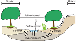
Kaushal and his colleagues found that denitrification rates were relatively high in areas of the stream channel, called the "hyporheic zones," where stream water could easily mix with groundwater and where denitrifying bacteria reside. (See illustration below)
The scientists also observed that increasing connections between a stream's flowing water and nearby wetlands and oxbows (remnants of the original stream channel) could yield significant denitrification in those zones, reducing by up to 40 percent the daily load of nitrate in the stream.
But the effects of denitrification varied depending on location in the stream's watershed and on the restoration design, Kaushal adds. The variation can reflect "hot spots" of extra nitrogen entering the channel from leaky sewage system pipes and other sources. The pipes frequently run along streams to skirt buildings and arrive at collection points downhill. Designing projects to restore and preserve urban streams, he says, requires considering hot spots along the streams' entire length, which he and his colleagues call the "urban watershed continuum."
"If you couple the stream restoration along with sanitary infrastructure repairs because you're already digging and excavating all that stuff, it can probably have significant effects," he says. "We have aging infrastructure not only in Baltimore and D.C. [but in other cities, too]."
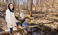
WHEN WE HEAR A SUMMER THUNDERSTORM at night, many of us roll over and go back to sleep. Solange Filoso, on the other hand, gets in her car and drives to a stream.
To study restored streams in Anne Arundel County, Filoso went driving by day and sometimes by night, in summer and in winter. Every two weeks, in daylight, she collected water samples from the streams for chemical analyses. She also measured the speed of stream flow during storms. "I remember being so wet once that I had to go to a store and buy new clothes and boots. I put them on and went back out there" to the stream to finish collecting data." more . . .
Findings by Kaushal and his colleagues about nitrogen removal within Minebank Run influenced the report of the Chesapeake Bay Program's advisory panel on stream restoration. Their results informed a method presented in the report for estimating the amount of nitrogen removed by restoration projects designed to promote denitrification in the hyporheic zones of streams.
Using a documented nitrogen-removal rate for this calculation "is a very good place to start," says Margaret Palmer, who has attracted national attention as an expert on stream restoration. She is a professor at the University of Maryland at College Park and the University of Maryland Center for Environmental Sciences (UMCES) and is now director of the National Socio-Environmental Synthesis Center in Annapolis. However, she continues, "the spatial variability in denitrification in streams is well known to be huge."
What Goes In, What Comes Out
Palmer has worked with Solange Filoso in another part of the Chesapeake watershed to study restored streams and their effects on water quality. The findings of this research are among the reasons both scientists voice caution about expecting restoration projects to significantly reduce nitrogen in streams.
From 2007 to 2010, Filoso, who was a member of the advisory panel on stream restoration, monitored conditions in six streams in Anne Arundel County that had been restored using different methods. Three of the restored stretches had been stabilized using natural channel design. Others were in lowland stream valleys and relied on the wide channel approach. Filoso worked to determine the "mass balance" — the amount of nitrogen flowing in and out — of restored stream reaches.
Filoso and Palmer found that only two of the six restored reaches showed statistically significant declines in nitrogen upstream versus downstream during normal water levels. And only one, Howard's Branch, reduced the amount of nitrogen exported downstream during storms.
Anne Arundel County has supported restoration projects (examples, left) that may promote the removal of nitrate from the stream's water. In a natural process, called denitrification, bacteria can convert nitrate into nitrogen gas (N 2) both in the groundwater below as well as along the sides of a stream bed, an area scientists call the "hyporheic zone" (right). A restoration project can increase denitrification by widening the stream channel to increase contact between the stream's surface water and groundwater. Maps, Anne Arundel County, Google data ©2015, (county outline and stream locations added by Sandy Rodgers); Maryland, iStockphoto.com/Texas map library; illustration (above), adapted from Fisher et al., Geomorphology 89:84-96 (2007)
The data also suggested that big storms tended to overwhelm the streams' ability to remove or retain nitrogen through natural processes. In the restored reach of Howard's Branch, the reduction in nitrogen occurred during storms with less than three-quarters of an inch of rainfall. However, larger storms that dumped more rain had an out-sized effect: although a minority of all storms, they contributed most of the water that moved downstream annually. And with that water went most of the nitrogen exported down the stream. At higher flows, dissolved nitrogen had less time and opportunity to come into contact with denitrifying bacteria, Filoso says.
So what was the overall amount of nitrogen that could be removed within a restored stream channel? Filoso and Palmer calculated that in a best-case scenario, a wide, restored stream could remove about 17 percent of all the nitrogen moving in the water within the stream channel annually. To put this removal rate into a broader perspective, such a restored stream was removing about 5 percent of all of the nitrogen loaded onto the surrounding land that drained into the stream. They assumed the nitrogen came from sources like sewage-system leaks, lawn fertilizer, pet waste, and atmospheric deposition in rainwater. (Some of the nitrogen deposited in a drainage area is retained there and never flows into a stream.)
Filoso and Palmer also studied how well features of the restored streams trapped sediment moving downstream. In findings yet to be published, they found that retention of sediment by restored reaches was relatively small in relation to inputs of sediment flowing from upstream sources. The amount of sediment stored was variable; during some bigger storms, more sediment was washed out and sent downstream than was retained. And the restored streams didn't retain more sediment than unrestored streams nearby did.
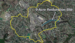
Overall, Filoso says her research findings make her worried that we may be expecting streams to do more than they can naturally do — and that we may be relying on them as a last line of defense before polluted stormwater flows into the Chesapeake Bay. Restored stream channels are often relatively small compared with the total surrounding area that drains into them, she notes. The restored corridor of North Cypress Branch, for example, measures about nine acres compared with a drainage area of 475 acres.
Filoso suggests that by relying more on stormwater management practices located upland, outside of a stream channel, we can reduce the volume of stormwater flowing into the stream. And in turn, we can avoid over-relying on the cleansing effects of denitrification and other processes that remove pollutants from stream water, whose effects vary over time and by location.
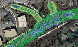
North Cypress Branch, a stream in Severna Park, Anne Arundel County, had been eroded by stormwater runoff from a 475-acre drainage area (outlined in yellow), which includes a shopping center and its parking lot (left). In 2013, the county and its partners concluded a project to improve the stream by designing a variety of structures — such as terraced step pools and a "braided" network of channels — that work to slow and widen the stream flow. Aerial images: (left) project designer BayLand Consultants and Designers Inc.; (right) project designers BayLand, Clear Creeks Consulting, and Underwood & Associates
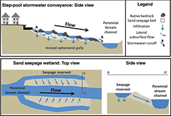
Stream restoration designs are selected depending on a stream's topography and other circumstances. In regenerative stormwater conveyances (top), step-like pools are installed in steeply graded streams below the outfalls of stormwater drainage pipes to control water rushing out during rainstorms. By contrast, wetland seepage systems (bottom) are designed for flatter stream channels. Side channels are built parallel to the stream flow to store stormwater runoff. Water in these "seepage reservoirs" (A) slowly flows through a constructed "sand seepage bed" to the stream (A'). Illustration, adapted from Palmer et al., Ecological Engineering 65:62-70 (2014)
"An analogy I make: if you have a sick patient, you don't go for the most invasive, extreme treatment right from the beginning," Filoso says. "You try to make an assessment of what may be causing the problem, and you try to eliminate causes. . . . When there's nothing more that you can do, then you go and do surgery. To me, stream restoration is more like surgery."
"It's funny, because when I came into this whole thing, I was really convinced that [stream] restoration could do more. I really thought, this makes sense. And I wanted it to work. But the data so far indicate that it doesn't do as much as I thought it would do."
Filoso adds that a fuller picture of the effects of stream restorations may emerge in future research projects that compare nutrients and sediments in the streams pre- and post-restoration. She wasn't commissioned to begin monitoring the six Anne Arundel streams until after restoration work there was completed. "Without long-term, good-quality data," she says, "it's really difficult to determine how the systems are working."
Crafting an Effective Toolkit
In its final report for the Chesapeake Bay Program, the advisory panel on stream restoration acknowledged concerns about its effectiveness as a tool to improve water quality and suggested ways to improve it. The report encouraged government managers and planners to couple stream restoration projects with management practices located upland to reduce stormwater flow into streams. (See Getting SMART about Clean Water)
But the upland practices, like installing drainage swales and removing impervious asphalt, present their own set of challenges — and costs, says Bill Stack. He served as a staff member for the advisory panel and is deputy director of the Center for Watershed Protection, a nonprofit based in Ellicott City, Maryland, that advises local governments and organizations. Previously he led stream restoration projects for the Baltimore City Department of Public Works. In that role, he oversaw an intensive effort to install stormwater-control measures in Watershed 263, an area of 930 acres encompassing 12 neighborhoods in West Baltimore. (For a detailed description of this project, see Chesapeake Quarterly, Vol. 7, No. 2.)
"I know how expensive these projects are. The cost is huge," Stack says. "The other issue is finding enough publicly owned property where you can put these practices in the ground that will make a substantive difference. . . . As a rule of thumb, if you're limited to publicly owned property, at best you can treat about 15 percent of runoff volume."
Because of challenges like these, it could take decades to install enough stormwater control measures in upland areas to improve the Bay's water quality, Stack estimates. Using his own analogy about doctors, he says that projects that reduce stream-channel erosion today will help "staunch the bleeding" of excess sediments and nutrients to the Bay — and buy time to allow other treatments to work.
BOB HAHN JR. AND PATTY HINKS live only a few houses away from each other in Severna Park in Anne Arundel County. Both of their back yards share the same, expansive view of North Cypress Branch and the stream restoration project completed there in 2013. But they hold very different views about the project's results. more . . .
When the advisory panel recommended ways to estimate by how much stream restorations reduced nutrients and sediments, it said it was taking a conservative approach to account for variability and uncertainties in performance. For example, the panel said the estimated reductions in sediments using the natural channel design approach should be cut by 50 percent. And stream restoration projects receiving credit for reductions will have to be monitored every five years to determine that they are still working as originally designed.
This monitoring and assessment is crucial, Stack says. "I'm concerned that a lot of managers, a lot of [engineering firm] practitioners, they see the high credits that stream restoration gives, and they're just going to jump on the bandwagon and start putting these projects in the ground without using a scientifically based design process that we can learn from and refine and tweak."
The Chesapeake Bay Program is pursuing this kind of iterative learning process, dubbed "adaptive management," to tweak a variety of interventions besides stream restoration in order to improve water quality and make progress toward meeting the Total Maximum Daily Load water-quality targets by the deadline of 2025. In addition, the program's Science and Technical Advisory Committee has prepared a new report about using science-based principles to design sustainable, effective stream restoration projects in the Chesapeake Bay watershed.
Designing projects that are consistently effective will require further work, says Tom Schueler, executive director of the Chesapeake Stormwater Network. With Stack, he also worked as a staff member for the advisory panel. Says Schueler, "We need a lot more science, a lot more economics, a lot more research and practice to make the best policy decisions about how to restore streams and how to do these other restoration practices in watersheds."
|