|
Vanished Chesapeake Islands
Annalise Kenney and Jeffrey Brainard
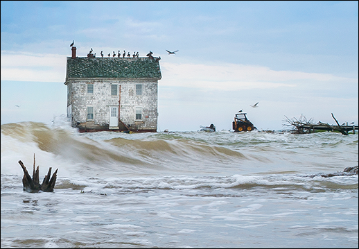
In this photograph, the last house on Holland Island was still standing — in 2010 it collapsed into the Chesapeake Bay, a victim of sea level rise and erosion. Photograph: David Harp
WHEN THE CHESAPEAKE BAY WAS SETTLED in the 1600s, colonists began to record in county land records the names of hundreds of islands, some of which they would farm and call home. There was Turtle Egg Island, and Sharps Island, and Parker's Island.
But today, more than 400 of those islands in Maryland and Virginia cannot be found on modern navigational maps of the Bay, wrote William Cronin in his 2005 book, Disappearing Islands of the Chesapeake Bay. The islands apparently were eroded away, a process accelerated by storms and sea level rise.
A few of these islands contained active settlements of watermen and other workers, although it's difficult to pin down in historical records how many. Some of the islands were only farmed. Archives of historical societies around the Bay do offer stories and records describing the rugged people who lived and worked on tenuous specks of land — like those on Maryland's Holland Island. Residents were forced to abandon the eroding island in the early 1900s. Before they left, many families disassembled their houses and barged them to the mainland of the Eastern Shore, where some of these structures still stand today. (Additional examples of disappeared islands appear below.)
Holland and some other islands in the Chesapeake persisted well into the 19th and 20th centuries, only to shrink relatively quickly over a period spanning only a few decades. Why did they fade away so rapidly? Two scientists at the University of Maryland, Michael Kearney and Court Stevenson, offered some insights in a study published during the 1990s in the Journal of Coastal Research — an analysis that Stevenson says he thinks still holds up today.
Rapid Decline after 1850
This 1877 map shows Holland Island (identified as "Hollands Island") to the southwest of Bloodsworth Island, in Dorchester County, Maryland. Holland Island once supported 360 people and 60 homes, but most of the population moved away by 1918 as the island eroded away. Chesapeake Bay map: iStockphoto.com/University of Texas Map Library; Holland Island map: JScholarship image from An Illustrated Atlas of Talbot & Dorchester Counties, Maryland, 1877, used courtesy of Sheridan Libraries of Johns Hopkins University
The scientists studied evidence of long-term patterns of sea level rise in the Chesapeake Bay. They wanted to examine a period of time longer than the one covered by tide gauges, which were deployed in the Bay starting around 1900 to record water levels. The scientists studied two other kinds of evidence that could indicate rates of sea level rise over a longer period. The scientists studied the rate of vertical growth of marshes since around 1790 by collecting cores of soil from a marsh on the lower Eastern Shore. They also analyzed old maps to estimate historic rates of land loss on selected islands there — including now-vanished ones like Sharp's, Hambleton, and Royston — since around 1650, when colonial settlement in Maryland was taking root.
Kearney and Stevenson concluded that, although the evidence had its limitations, it indicated that sea level rose relatively slowly during the 1600s and 1700s. But then the rate of increase more than doubled between around 1800 and the latter decades of the 20th century. The Bay's sea level has risen about a foot over the past century.
The scientists noted that the acceleration was sudden enough that some island residents fled eroding and submerged land on which they had built houses and stores only a decade earlier.
Why did sea level apparently accelerate so substantially in the Chesapeake after 1800? Kearney and Stevenson cited a general warming in global temperatures since then. The year 1850 was near the end of a naturally occurring, 300-year period, called the Little Ice Age, when temperatures cooled globally. And during the 1800s, the Industrial Age was taking off. Emissions of greenhouse gases by industry and other human activities eventually helped cause warming temperatures worldwide; the results included expanding oceans and rising sea levels globally.
"Around the same time [after 1850], all the islands that we tracked collectively started to lose more area," Stevenson says. "And we attributed this to industrialization — and increase in CO2."
Additional factors particular to the Chesapeake added to the increase in sea level here, Kearney and Stevenson wrote. For example, groundwater withdrawals may have increased the rate at which land in the Chesapeake region was sinking, exposing more of the islands to the rising sea.
Small islands, and those at low elevation, would have been the most vulnerable to erosion. According to the land records described in Cronin's book, about one third of the 400 islands measured 10 acres or fewer.
Four hundred islands seem like a lot of lost land and memories. However, that number may have been inflated by a lack of precision in the old land records. Some of the 400 islands may have been recorded more than once in property records under more than one name. In addition, mapmakers overlooked the recorded names of some islands, Stevenson says. "They're still there, they're just unnamed" on modern nautical maps, he explains.
Here are snapshots of six vanished islands that were known to have existed and that left behind a legacy beyond the land records — stories of persistence and work and roots that are now gone.
Holland Island: Picking Up and Moving Away
Holland Island, off Dorchester County, Maryland, was home to watermen who dredged oysters in the heyday of the Chesapeake's oyster fishery in the 1800s. By 1910 the island held nearly 360 people, 60 homes, seven stores, a church, and a two-room schoolhouse, according to records. But as the 20th century began, westerly waves in the Bay were edging closer to the islanders' wooden clapboard homes.
The families noticed, and began moving away. The late I.T. Todd, Jr., an early owner of the MeTompkin Bay Oyster Co. of Crisfield, Maryland, was one year old when his family left the island in 1918. Today, his son, Casey, owns the MeTompkin company and tells stories about when and why the family left.
"My grandmother knew it was time to go when she could throw her dishwater in the Bay," Casey Todd says. "The year before they left the island, their house was on the edge of the higher side of the island. The water had come right to their doorstep."
Board by board, the islanders tore down their houses, school, church, and stores and rebuilt them in the nearby fishing towns of Crisfield and Cambridge. "[Watermen are] working people," Todd says. A small remnant of Holland Island remains today, but the last remaining house, long abandoned, crumbled into the Chesapeake in 2010.
Today, erosion continues to eat away at other remaining, inhabited Bay communities, like Maryland's Smith Island.
"People talk about sea level rise, but for us, living here for generations, this is nothing new," Todd says. "We've had erosion and sea level rise for 200 years. The seaside communities have been dealing with it. ... We can literally watch it."
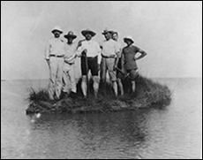
In 1950, a group of people, dressed in attire from the early 20th century, posed for a photo on a small speck of land, all that remained of Sharps Island. It once measured as much as 700 acres and was home to a hotel and farms. Photograph: courtesy of the Hanks family
Sharps Island: Vacancy in a Hotel
Sharps Island, off Talbot County, Maryland, was once home to a three-story, Victorian-era hotel, according to William Cronin's book.
Built in the late 1800s by Miller R. Creighton, a shoe manufacturer from Baltimore, the hotel had a long boardwalk and steamboat pier. By the early 1900s, erosion had claimed enough of the island that it was closed and torn down. Its lumber was carried off to build houses on nearby Tilghman Island. By 1963, the island had vanished.
Turtle Egg Island: Pirates of the Chesapeake
Some now-vanished islands, like Turtle Egg Island in Dorchester County, provided hideouts for pirates who plagued the Chesapeake region in the 1600s.
One infamous pirate named Roger Makeele appears in Maryland records in January 1685. Makeele and his crew of nearly 20 men and women plundered Chesapeake Bay vessels, towns, and Native American settlements from Tangier Sound in Virginia to the Choptank River in Maryland and reportedly some western shore homes in Maryland. When the Maryland Council issued a warrant for Makeele, the pirate fled the region for the sounds in North Carolina, another haven for pirates of the time.
"Swan Isle" and "Puddiford's Chance": Rewards for Servants
Small islands in the Chesapeake were bequeathed to indentured servants as early as the 1670s, William Cronin wrote. These servants were an important part of the colonial community. People who could not afford to travel to the New World had the option of signing themselves into servitude for a designated period of time. When their indentured time ended, the servants were given land, clothing, and farming supplies in order to establish themselves as free men.
In 1670, land records indicate that a man named Thomas Hooten received "Swan Isle" at the end of his period of servitude. Another servant, David Puddiford, was given "Puddiford's Chance" in 1672. The islands provided in those gifts are now gone. Swan Isle was located off Hooper's Island; the location of Puddiford's Chance is unknown.
Parker's Island: Newcomers Arrive, then Move Again
Erosion has led to high rates of erosion on the Eastern Shore of Maryland and Virginia because prevailing westerly winds push water southeast across the Bay. However, some of the disappeared islands were on the Bay's western shore.
In the 1850s, ten Eastern Shore watermen moved their families across the Chesapeake in search of new oyster grounds. They had discovered the Bay Shore Bar, a huge natural oyster reef off of Anne Arundel County. To fish it, the families settled on Parker's Island, likely named for William Parker, a prominent Anne Arundel County settler.
But soon after the Eastern Shore settlers arrived, they realized their island was eroding away. The settlers relocated to the mainland, founding the small waterfront community of Deale, Maryland.
Sources of information about these islands: Holland Island — interview and Talbot County Public Library; Sharp's Island, Swan Isle, and "Puddiford's Chance" — Disappearing Islands of the Chesapeake Bay, by William Cronin; Turtle Egg Island — Dorchester County Public Library; Parker's Island — Harford County Historical Society and Anne Arundel Historical Society
Annalise Kenney was a Maryland Sea Grant communications intern in summer 2014.
|