|
Snapshots from the Edge
In this eroding Eastern Shore region, flooding is a common sight, and not just after big storms
Rona Kobell, Bay Journal
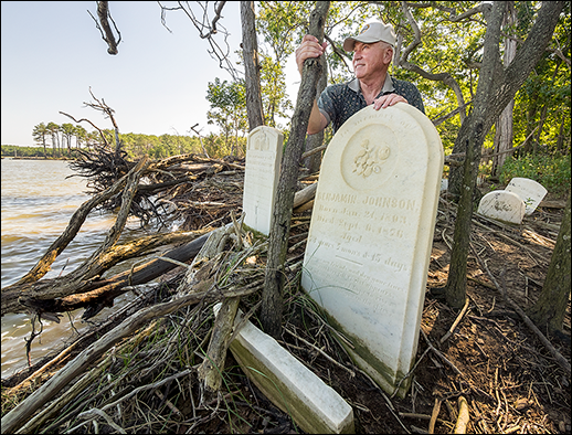
Growing up in Dorchester County, James Adkins (above), adjutant general of the Maryland National Guard, explored Wroten Island, where his ancestors once lived and were buried. Today, their graves are underwater in the Chesapeake. And headstones like those shown here on Wroten and elsewhere on the lower Eastern Shore are at risk of being submerged. Photograph: David Harp; Map: iStockphoto.com/University of Texas Map Library
ALL OVER LOW-LYING DORCHESTER COUNTY, residents are living on the edge. One skid off the road puts a car in a marsh. Parking in the wrong place during the wrong arc of a tide cycle can lead to a flooded car. Water that used to just graze residents' yards now comes up to the porches; it's just a matter of time, they know, before it comes into the houses.
Here, in the land of narrow marshes and proud working waterfront towns, the high water isn't just coming. It's already here.
School buses can't get down the road like they once did, and those roads need constant repair. Land at the edge of banks is fast disappearing, swept away in tides and storms. Forests are dying, inundated by rising salt water. New homes are being built at least a foot higher than in the past. And storms, particularly tropical systems and hurricanes with their attendant storm surges, push water ever higher along these shores.
But many longtime county residents don't connect the problems to the two underlying phenomena that scientists say lie at the root of rising waters here on the lower Delmarva Peninsula — climate change that raises sea level and sinking land.
They know what they are seeing, but many blame the problem on erosion, or "tides." Many don't want to talk about melting ice sheets or greenhouse gas emissions. They want to talk about fixes today that may help to get the water out of their yards, fixes such as the reconstruction of barrier islands in the Chesapeake Bay.
"I talk very carefully on the Eastern Shore," said Bill Boicourt, an oceanographer who has studied the area's rising waters and is based at the Horn Point Laboratory at the University of Maryland's Center for Environmental Science in Cambridge. Several times a year, Boicourt speaks to church groups and civic organizations about how climate change works, how temperatures and sea level and storm surges are rising while land along the Eastern Shore is sinking. Not everyone buys his message. "I respect their perspective," he said. "They range from an open skepticism (about climate change) to a closed skepticism."
It might seem surprising to find skepticism about sea level rise in Dorchester County. Stretching south from the Choptank River down to the Nanticoke, this low-lying county is laced with rivers, creeks, bays, and swamps that frequently flood the land.
And more high water is coming. A scientific panel concluded in 2013 that sea level on Maryland's coasts is likely to rise over the next century by 3.7 feet and as much as 5.7 feet. The current rate of increase is about twice the national average. Dorchester is especially vulnerable to higher waters because it is the second-lowest-lying county in Maryland (after neighboring Somerset County) and one of the lowest in the United States. More than half of Dorchester is less than five feet above sea level. Prevailing winds blow across the estuary from the northwest, building up wave energy aimed right at the lower Eastern Shore.
Looking around, it's easy to see what's already gone. On Hooper's Island, residents lose about 24 acres a year. Hooper's was once three islands: the high ground of Fishing Creek, the middle ground of Hoopersville, and the lower island, known as Applegarth. Islanders lost the bridge to Applegarth in a 1933 storm; fewer than 100 residents inhabit Hoopersville now, and more leave every year. Fishing Creek is on relatively high ground, but people there grapple with floods during high tides and even unnamed storms.
Jay Newcomb understands this problem all too well. He's the president of the Dorchester County Council, the manager of Old Salty's, a popular Hooper's Island restaurant, and a longtime school bus driver in a place where buses never last long because of saltwater damage. Rare among his neighbors, Newcomb does think the rising waters in the Bay are related to melting polar ice.
One day last year, near Toddville, children riding his bus took off their shoes and hiked up their pants before wading through high water to get to their front doors. Another day, some children didn't bother riding the bus to school because of flooding from high storm tides. They weren't sure they'd get home.
It's a struggle to maintain the island's roads with the county's $3.6 million annual transportation budget. Trucks rumble down the road to Bishop's Head with fill and dirt and come back empty. The road gets repaired, but then like many other roads, it washes out again.
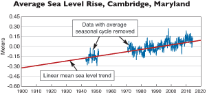
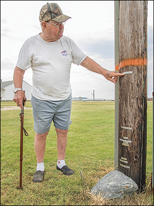
Some waterfront property owners around Maryland regard rising water and erosion as temporary trends. But tide gauges in the Chesapeake Bay have recorded a steady rise in water level, as shown by these data (graph, above) from a gauge on the Choptank River in Cambridge, Maryland. Here, sea level is shown on a relative scale. Extrapolating, the Cambridge data indicate a total rise of 1.14 feet in 100 years. During the 35 years that Harold Cartright (right) has lived on Hooper's Island in Dorchester County, his property has been flooded by Hurricanes Fran, Isabel, and Sandy. On a utility pole on his property, he recorded their names — and heights. Here he points to a tag for Isabel in 2003. "I want this as a permanent record," he said, "of what hurricanes did to this property." Photograph: David Harp; graph: National Oceanic and Atmospheric Administration
Septic fields and wells flood, too, and residents must worry about the contents of fuel tanks leaking out in the high waters and contaminating wells and soils.
The conditions have prompted many people to leave.
"We have less kids here all the time," Newcomb said. "We used to have three buses taking kids to Cambridge for high school. Now, there's just one bus."
Disappearing trees are another stark example of sea level rise in the region, says Johnny Shockley, a 50-year-old entrepreneur who's stayed in the area to run the Hoopers Island Oyster Aquaculture Company. As a boy he ran along Wesley Church Road, through woods that are now marshes dotted with acres of dead trees, their long, sad trunks graying from the Bay's brackish waters.
Shockley, however, remains a skeptic about whether this is the product of climate change. He knows that scientists have presented evidence that warming temperatures globally are at least partly to blame for Dorchester's higher water. He's just not sure he believes it. "I understand the concept, the reasons why they're saying we got global warming," he said. "But I can't verify what they're saying is true."
Shockley loves his threatened island and wouldn't want to have his oyster farm anywhere else. He's got breakwaters reinforcing his waterside facility, which offers a panoramic view of what Shockley's father, Dorsey, describes as "waterfront and waterback." A tough businessman who's won just about every award for his innovations — even one from the White House — Johnny Shockley becomes surprisingly emotional remembering his now-lost boyhood woods. "Those trees are dying. It's obvious," Shockley said. "Where the marshes meet the woods, the marsh is taking over."
What are the options? Many of the residents along Dorchester's low-lying shoreline believe that the state and federal governments could do more to protect county residents. In particular, they advocate building up barrier islands in the Chesapeake that once offered this stretch of the Dorchester shoreline protection from storms and erosion. Many of these islands are gone, and others that remain are washing away.
A decade ago, the Army Corps of Engineers raised hopes of residents by proposing to use sediment dredged from the Bay's shipping channels to replenish two of these disappearing islands, Barren Island and neighboring James Island. A rebuilt Barren Island would help shield the shorelines along Hooper's Island. And an expanded James Island would protect Taylor's Island at the northern end of Dorchester County. The Corps has enjoyed success using this approach to replenish another barrier island, Poplar Island, offshore from Tilghman Island. Once a shrunken remnant measuring just four acres, Poplar now holds more than 1,000 acres of restored land. To do the same for Barren and James, the estimated price tag: $2.8 billion in 2008.
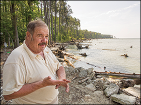
For years, funding for this proposed Mid-Chesapeake Bay Island project has been stalled. "Back in 1990, the Army Corps of Engineers did a study. They recommended protection for certain hot spots. Now, 24 years later, they haven't done a thing," lamented Bruce Colson, who owns the Taylor's Island Family Campground along Bay Shore Road, just 15 miles north of Hooper's Island. "It seems like it takes the government so long to get anything done."
The delays have cost Colson. He owns 15 acres, according to his deed. Five are now unusable, having been swallowed by rising water. Colson, too, says the sea level is not rising. He blames his problems on erosion.
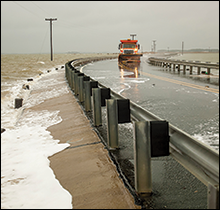
To reduce erosion along Dorchester's shoreline, the government should build up two nearby barrier islands, Barren and James, says Bruce Colson (left), who owns the Taylor's Island Family Campground. On Hooper's Island (right), a dump truck plows through high water being pushed off the Bay and across the narrow bridge that connects the upper and middle parts of the island. Sea level rise allows storms to push water further inland. Photographs: David Harp
As vice president of the Dorchester County Shoreline Erosion group, he leads a citizen organization that advises homeowners on options for property protections. There are state tax credits for shoreline protection, for example, as well as assistance for building a living shoreline (a buffer of natural vegetation, more environmentally friendly than hardened sea walls). The group also has been lobbying for the Corps to begin the Mid-Chesapeake Bay Island projects.
Now there's new hope. The Water Resources Reform and Development Act of 2014, which President Obama signed into law in June, authorizes the work. Congress hasn't appropriated the money, however. And despite the hopes of residents that the work may protect their shores, the project is listed as an environmental restoration project, rather than a hurricane and storm damage risk reduction project.
For those who can't armor their property against higher waters, the only other option is moving. That's what Jim Brown decided when the water began reaching the upper step in the home he shared with his girlfriend, Cynthia Thompson, near the Taylor's Island campground. Now they live in nearby Woolford — not high ground, but higher.
Brown, a construction worker, came to Maryland from North Carolina to rebuild homes after Tropical Storm Isabel struck here in 2003. An avid fisherman, he takes his boat, the Rock-Crazier, to the coves and inlets around James Island, searching its Jurassic-like terrain for wildlife. One day in 2013, he was fishing along a small beach at James Island. The next day, the beach was gone — erosion, Brown said.
Each spring, on the first nice day, Brown sets off for James to see what was lost during the winter. At times, he's estimated the loss at more than 100 feet. Trees grow out of the water, like dead sticks, to mark the places no longer there.
"She's washing away. Simple as that," Brown said. "She's washing away."
Perhaps no one understands both the devastation the floods can bring and the pull of these low-lying lands better than James Adkins. When Hurricane Sandy arrived in 2012, it flooded parts of Dorchester, and in neighboring Somerset County, it inundated almost all of Crisfield. As adjutant general of the Maryland National Guard, Adkins had the job of leading the Guard's rescue operation in Crisfield during a flood disaster that drove 500 people to shelters and damaged 700 homes.
Born in Dorchester County, Adkins grew up exploring the woods and nooks on Wroten Island, where his family came from. The island is near Crapo and Toddville, near marshes holding stands of dead trees. Today, the graves of Adkins' ancestors are underwater in the Chesapeake.
Adkins still comes back to the lower shore. He and his wife Mary Anne keep a condominium high above Crisfield's City Dock. From there he can see the Chesapeake glistening and the lights still on in the large peeler crab operations below. But also he sees a city in tatters. Handwritten "for sale" signs adorn many shop windows. The former Sterling Hardware Building on Main Street sold at auction for just $30,000 in June. It had previously sold for $700,000. The city still calls itself the "seafood capital of the world," but it hardly resembles the thriving waterman's town where Mary Anne Adkins grew up in the 1960s and where her father operated a railway that carried the Bay's bounty to market.
Sandy "surprised a lot of people," James Adkins said, and served as a wake-up call to longtime lower-shore residents. "We used to see loads of people who would come down here," Mary Anne Adkins said. "I don't see a lot of people anymore."
Asked how the counties can address the one-two punch of rising waters and sinking land, Adkins was quiet. Then, he said, "Can you really stop nature?"
|