|
Norfolk: The Navy on the Leading Edge
Leslie Middleton, Bay Journal
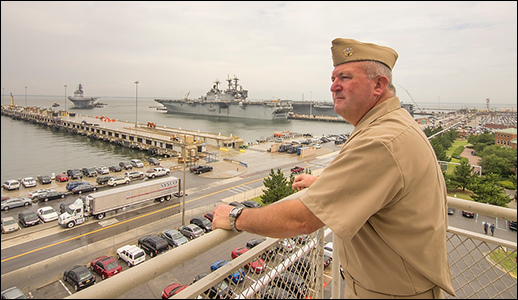
U.S. Navy Captain Bob Clark looks out over Naval Station Norfolk, which he commands. This base, the largest naval facility in the world, is considering raising its piers so that rising waters do not disrupt its bustling operations. Photograph: David Harp
BARELY A MONTH AFTER REAR ADMIRAL DIXON SMITH TOOK COMMAND of Navy Region Mid-Atlantic in Norfolk, a nor'easter blew through, showering the naval station here with what he thought was a fairly moderate amount of rain. "I was stunned at the localized flooding on the streets," he says, "and it wasn't even a hurricane."
Since then, heavy rains have repeatedly forced Smith to use his front door because his backyard is flooded. While he is stationed in Norfolk, Smith lives in an historic house on Admirals Row. Like much of Naval Station Norfolk, the homes in this part of the naval station are built upon former wetlands filled to make space for the 1907 Jamestown Exposition.
Naval Station Norfolk is the world's largest naval base and home port to over 75 ships of the fleet that defends U.S. interests in the Atlantic Ocean, the Mediterranean Sea, and the Indian Ocean.
It is also one of the Navy's most vulnerable.
Norfolk and the surrounding Hampton Roads area, which is home to 28 other defense installations, is experiencing one of the fastest rates of sea level rise in the United States because of the combined influences of rising seas and subsiding land.
Most of the station lies 13 feet or less above mean sea level. Some scenarios project that waters around Norfolk will rise by six feet or more in the next 100 years, and studies by the U.S. Army Corps of Engineers show that 60 to 80 percent of the station could be flooded during storms the size of Hurricane Isabel in 2003.
But while numerous studies have shown that a smaller rise in sea level will inundate major portions of the naval base and other installations, the Navy has yet to make a comprehensive plan — nationally or locally — to deal with the challenge.
But not for want of critical attention.
The last two Defense Quadrennial Reviews (an in-depth examination of strategy) have pointed to the mounting threats to national security, abroad and in the United States, of the effects of climate change. The Navy has formed a climate change task force and is in the process, along with the other armed services, of evaluating the operational and installation vulnerabilities of facilities around the world. The Army Corps of Engineers' research arm developed sophisticated models for predicting sea level rise impacts, first looking at different scenarios at the Norfolk base and now using these methods at other defense installations.
All of this planning is intended one day to help naval leaders like Captain Bob Clark, commanding officer of Naval Station Norfolk. From the sixth story of the Ops Tower, he has a panoramic view of the Navy's 13 piers and the rest of the base. On the waterfront below him, the flow of fuel, aircraft, munitions, and housekeeping services is a highly orchestrated logistics exercise that is performed round the clock, in almost any kind of weather. Under stormy skies, a phalanx of tugboats tends to the amphibious landing craft USS Iwo Jima, while delivery and maintenance vehicles navigate between and around steam pipes, overhead cranes, and pedestrians.
Sea level rise and storm surges could disrupt this steady flow of activity in several ways, Clark says. When the water rises with a storm surge, port operations shut off steam and electric power to the ships docked alongside the piers, forcing them on to ship power, which is less efficient and more costly than shore services.
"We have close to 54,000 people who work here," Clark says, "with an average of 40,000 coming in and going out every day." But flooding during rainstorms on Hampton Boulevard outside the station regularly impedes the flow of traffic to and from the station. And requires port ops to move scores of cars from a parking lot near the airfield that regularly floods.
"It's a readiness issue," says Clark, whose many responsibilities often leave little time for thinking about a future of rising sea levels.
"We have a lot of aging infrastructure," Clark says, adding there are no projects in the works at Naval Station Norfolk to address sea level rise but noting he expects that it will be considered when the Navy replaces the piers.
Right now, the only specific project the Navy can point to that has planned for sea level rise in the Norfolk area are two oil-tanker piers the Navy is building across the Elizabeth River at a separate facility on Craney Island. These will be three feet higher than the piers being replaced, raised to protect the utilities from wave damage and flooding. The height increase was limited by the operational limits of current ships and equipment, said Beth Baker, a spokesperson for the Navy.
Defense Department guidance currently specifies only that the effects of climate change be "considered" in planning efforts, says Captain Pat Rios, the Navy's lead engineer for the Mid-Atlantic region.
But the interface between facilities and operational planning is complex and requires evaluating many needs and tradeoffs, Rios says. "I'm clocking through 10 different things that are considerations as I go through the day." What are the support requirements for the aircraft, the ships? Where to buy fuel? What's the best crane for an operation? "There are just hundreds of considerations, not just sea level rise."
There are signs that the naval station and the community that surrounds it are gaining some traction in planning for sea level rise by working together.
This year the White House announced that planning already underway between local governments and federal facilities in the region would serve as a model for other communities seeking to deal with sea level rise. The collaboration was officially named the Hampton Roads Mitigation and Adaptation Pilot Project and was kicked off at a June conference in Norfolk organized by Old Dominion University. The event brought together Navy personnel, scientists, academicians, industry, regional planners, and local government officials.
Many of the presentations focused on the need to develop a common set of data about impacts of sea level rise across multiple agencies and institutions so that regional decision-making starts from a common baseline.
It's an approach borne of necessity and mutual dependence, Admiral Smith says. The Norfolk region relies on the Navy and other Defense Department installations for almost half of its economic activity. The base relies on local utilities for power and water, and the transportation infrastructure connects the base by land to the rest of the region.
"If we do something and [the city of] Norfolk doesn't do anything, but Virginia Beach does, are we getting where we need to be? I think not," says Smith, who serves as the Navy's representative on the coordinating body for the planning project. "So we've got to work together."
But the planning effort is constrained by the fact that neither the Navy — nor the region — has yet to settle on a specific projected rate of sea level rise for the Norfolk region, a number that would in turn drive its decisions about how to adapt.
Whether to allocate federal dollars toward sea level rise adaptations at Naval Station Norfolk is a decision for Congress and should be part of a national policy on sea level rise, Smith says. "It's something we have to do as a society," says Smith, who commands the Navy's shore-based activities from Maine to Virginia. "You may have to retreat a little bit. Who knows, maybe 30 years from now there may be a part of this base we're not using anymore."
In the meantime, Smith says, the Navy has a huge investment in infrastructure not only in Norfolk but also all over the world, and Navy managers have to balance the current needs to fix leaking roofs and repair roadways with planning for future operational capabilities. The Navy, says Captain Rios, strives to meet these needs "just in time" — not too soon, not too late, balancing a future of unknowns against today's resources.
Only time will tell whether the Navy's planning efforts — along with efforts by the rest of Hampton Roads — will be implemented "just in time."
|
