|
Armor, Adapt, or Avoid?
Policy experts consider the challenges ahead in preparing coastlines and communities for the effects of sea level rise
Rona Kobell, Bay Journal
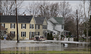
Sea level rise could reshape coastlines across the Bay, including along the narrow spit of land that makes up Hooper's Island in Maryland. The island loses about 24 acres each year to erosion. Photograph: David Harp
WHEN SUPERSTORM SANDY DEVASTATED the New Jersey shore and flooded lower Manhattan two years ago, it illustrated some tough and surprising truths about how we prepare for — or ignore — the risks posed by coastal flooding in the Chesapeake Bay region.
People in New Jersey and New York never expected the scale of damages from Sandy, and here in the Chesapeake Bay, a big storm could give us a similar nasty shock. Rising sea level is projected to increase flooding and worsen the effect of storm surges in this region — not only in small waterfront communities but also in larger cities like Annapolis, Baltimore, and Norfolk. And, scientists say, the incremental rise of sea level here could bring a slow-motion increase in flooding that nevertheless will bring expensive and disruptive consequences.
History has shown that Americans and their leaders have tended to react to coastal-flooding disasters rather than prepare for them. Sandy also highlighted that under current government policies, it can be difficult to mandate that counties and municipalities stop building in areas vulnerable to coastal flooding and sea level rise.
Nevertheless, the massive storm helped to focus the attention of officials and residents in Maryland and Virginia on the need to reduce these risks, and some progress is being made. Inevitably, the fixes needed are expensive, and funding to pay for them limited, raising questions of fairness about what areas to protect first. To change the status quo, experts say, governments will need to provide focused leadership and craft better policies — in areas like federal flood insurance and seawall construction — that better balance the risks and benefits of coastal development.
The Chesapeake's Special Risks
The risks of coastal flooding and sea level rise are especially great in the Chesapeake Bay region. Its land elevation is one of the lowest in the United States, and sea level here is rising faster than the global average. In Maryland, scientists' best estimate is an increase of more than 3 feet by 2100. In Virginia, scientists estimated the rise by then will be 1.5 to 7.5 feet.
The effects of sea level rise today are becoming harder to ignore. Recent science-based reports have described how streets and waterfront neighborhoods in Annapolis, Baltimore, and Norfolk have become flooded for more and more days each year, and those trends are likely to continue.
Residents will bear the costs of coastal flooding through expensive repairs to homes, loss of their cars, and lost time at work. In all, the Delmarva Peninsula of Delaware, Maryland, and Virginia contains 183,000 residents, 116,000 homes, and $42 billion in property value located less than five feet above the local high tide line, according to Climate Central, a nonprofit organization based at Princeton University. Even people who don't live on the coast will have to pay, one way or another, for the effects of the flooding through public expenditures for disaster relief and to raise and replace flood-prone roads and other public infrastructure.
The Push for Policy
For many Americans, it may be all too easy to ignore or deny projections of future sea level rise. The occasional big storm illustrates the problem, but between storms, sea level rise in the Chesapeake Bay and elsewhere is so gradual that it is easy not to think about.
You can see this resistance to change in other parts of the country. Three hundred years ago in Louisiana, early settlers built homes on stilts above marshes and boated from place to place; but by the 1940s, bayou residents wanted their homes to look like other neighborhoods. Katrina deluged those low-sitting homes and the roads leading to them. And in 2008, when Hurricane Ike tore through the Bolivar Peninsula next to Galveston, Texas, the force of the storm killed 15 people and destroyed many small fishing cottages. But in both Louisiana and Texas, houses have been rebuilt without regard to whether they can withstand future flooding.
This year, the National Research Council, one of America's top scientific organizations, issued a report expressing serious concern about our nation's lack of coordination and preparedness for the coming sea level rise. The report, which the council wrote at the request of the U.S. Army Corps of Engineers, urged federal officials to work with the states to develop a national policy sooner rather than later.
"Living in these areas in a sustainable manner necessitates that we move away from the current disjointed and largely reactive approach to dealing with coastal natural hazards and instead develop a more systematic, proactive approach to managing the risk associated with living in coastal areas," said Richard A. Luettich, Jr., the report's lead author and a professor of marine sciences at the University of North Carolina, Chapel Hill.
A national policy would consider where the risks of coastal disasters and economic losses are highest, says the report, Reducing Coastal Risk on the East and Gulf Coasts. Such a plan should provide incentives to local and state governments to protect vulnerable areas before disasters hit.
The report acknowledges that not everyone will welcome a national policy on sea level rise. Among those who won't: limited-government advocates, developers, and local government officials who seek to grow their tax bases through waterfront development. But without a national approach to sea level rise, the report argues, "different federal agencies and regional and local jurisdictions plan for and invest in risk reduction in ways that are often inconsistent, leading to inefficient and, too often, inadequate outcomes."
Hans-Peter Plag agrees. The German-born director of the Climate Change and Sea-Level Rise Initiative at Old Dominion University in Norfolk has watched the Netherlands take a national approach to disaster planning while the United States has not. After Hurricane Katrina flooded New Orleans, people considered the storm a Louisiana problem. The lack of the big picture, Plag said, will cost Americans dearly.
"We are making decisions now that are harmful for our children," he said. "Because we are afraid of doing what is really necessary."
Acceptable Strategies of Risk
To do what is necessary to protect against coastal flooding and the effects of sea level rise, there are basically three options. One is armoring: property owners and governments can protect shorelines with hardened structures like stone jetties and seawalls. Another option is adaptation: governments can require that homes be raised, and property owners can do so voluntarily. A third option is retreat: moving away from places that people have called home. Some governments have offered to buy out homeowners in low-lying, flood-prone areas, like Somerset County did on Maryland's Smith Island last year. (Residents rejected the offer.)
Retreat is not a popular option, although in some places in the Chesapeake region, nature has imposed it through the steady processes of sea level rise and erosion. Old maps of the Chesapeake Bay bear witness to that — they list the names of many islands that have been submerged. In Maryland's Dorchester County, there's a road named for Punch Island. But there's no more island at the road's end.
This flooded street in Cambridge, Maryland, is appropriately named Water Street. It floods routinely during abnormally high tides from the adjacent Choptank River and the city is forced to close it to traffic. Photograph: David Harp
More common responses to sea level rise involve adaptation and armoring. Recently, the Union of Concerned Scientists identified many cities, including Annapolis, Baltimore, D.C., and Norfolk, at increased risk from tidal flooding, and for these and other large cities abandonment seems implausible.
Critics complained that Norfolk was slow to acknowledge its flooding problems. But four years ago when the city decided to adapt, it did so with gusto. The city embarked on a new readiness plan for flooding. Millions of dollars are pouring into Norfolk and Hampton Roads — from the federal government, state government, and private foundations — to make the city more resilient. All over the city, you can see homes in various stages of being lifted and other projects to protect shorelines from flooding. Norfolk is on the radar screen of the region, the nation, and even the world. Recently, city officials went to Europe to discuss their policies.
Not all communities have the means to follow Norfolk's lead. Adaptation and armoring require not only determination but money, which Norfolk has — but which many smaller communities in the Chesapeake region don't.
For example, Saxis, on Virginia's Eastern Shore — year-round population, 242 — is struggling to find about $1.6 million for its share of a project to install eight breakwaters. Superstorm Sandy knocked the town to its knees, flooding about half of the more than 200 homes there. Had the breakwaters been in place prior to Sandy, town officials believe the damage would not have been as extensive.
"We're sitting here, every storm, and we're losing land," said Saxis Mayor Denise Drewer. "And people are getting more concerned, because it's getting closer and closer to their back doors."
Saxis is not the only such community. Tangier Island tried, starting in the early 1990s, to secure funding for a promised jetty. The funds for that work were finally approved two years ago, and work is finally beginning.
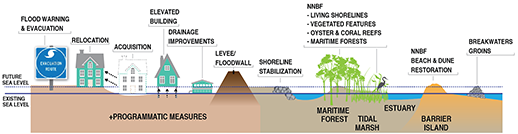
A combination of strategies have been developed to help manage the risks of coastal flooding. Some, like elevating buildings, are structural. Others, like “living shorelines,” are nonstructural and rely on natural resources (marked in the drawing above as NNBF, for natural and nature-based features). A number of experts have urged federal and state governments to devise a national, coordinated plan to manage flooding risks using a variety of methods. Illustration: U.S. Army Corps of Engineers
Looking for Help
Such delays are common because these small communities wait in line with many others — including coastal cities like Norfolk, New Orleans, and Miami — for funding from the U.S. Army Corps of Engineers for their construction projects. The Corps currently has an enormous backlog of such projects nationwide, amounting to about $60 billion. But Congress allocates only about $2 billion per year for these projects and others to improve waterways and harbors. Adding to that backlog, most of the funding for these projects comes from the Water Resources Development Act, which Congress declined to reauthorize for seven years, from 2007 until 2014. (It finally did so in May 2014.)
For a community to receive priority on the Corps project list, it helps to be represented by a powerful member of Congress who can push the project in federal legislation. Otherwise, many communities that line up for this money will end up continuing to wait.
"I could name a dozen communities in Virginia that are all facing the same problem," says Skip Stiles, executive director of Wetlands Watch, a nonprofit organization in Norfolk. "I can't tell you who is more deserving of a $4-million breakwater. How do you choose?"
Flood Insurance Follies
In addition to the Army Corps of Engineers projects, changes have been proposed for a federal program affected by coastal flooding and sea level rise: the National Flood Insurance Program. But it remains to be seen if the proposed changes will be enough to promote the program's survival.
In many coastal areas, lenders require flood insurance as a condition of a mortgage. For many borrowers, the federal flood insurance program is the only place to obtain an affordable policy. Under the program, private insurers sell policies, but FEMA sets the rates and pays for the claims. The program gives discounts to residents of towns that implement flood-control measures. These include up-to-date emergency-management plans, evacuation routes, and zoning that restricts building in floodplains. In Maryland and Virginia, state planners work closely with the local governments to institute these measures to qualify for the discounts.
But the rates do not fully cover the risks or the program's costs. After Hurricane Katrina, the flood insurance program was about $25 billion in debt — a tab that all American taxpayers may ultimately have to pick up. Sandy made that debt even larger, re-igniting cries for reform. The program has paid claims for "repetitive losses," effectively subsidizing the risks of individuals who chose to continue living in flood-prone areas after sustaining damage from multiple storms.
In 2012, Congress passed a law, signed by President Obama, to fix that disparity. The Biggert-Waters Flood Insurance Reform Act would have ended subsidies for homes built in flood-prone areas, and it adjusted future insurance premiums to reflect the true cost of coverage. It also phased out funds for repetitive losses, ending the practice of rebuilding in the same flood-prone area over and over again.
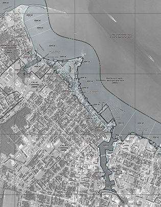
This Digital Flood Insurance Rate Map (DFIRM) published by the Federal Emergency Management Agency (FEMA) in 2015, shows downtown Cambridge, Maryland. Owners of homes within certain areas on the map are required to buy federal flood insurance to qualify for a mortgage. The fairness and financing of the federal program have been debated in recent years following Hurricane Sandy. FEMA recently rolled out revised rate maps for Maryland (including this one in Dorchester County) and other states that it says are more accurate. Map: Federal Emergency Management Agency
The outcry was fast and swift — from coastal homeowners, municipalities, and developers. Under pressure from constituents, Congress passed another law, the Homeowner Flood Insurance Affordability Act of 2014, which rolled back many of those provisions. It did phase in over two years a rate hike of up to 18 percent for primary homes and up to 25 percent for secondary ones and homes that flood frequently.
The federal government has also rolled out a related effort to improve another aspect of coastal protection: new maps of flood plains. These maps show areas that every year have a one percent chance of being inundated by floods — that is, these areas will likely be flooded at least once every 100 years, on average. Homebuyers within these designated flood plains typically are required to buy the federal flood insurance to qualify for a mortgage. Previous flood maps were considered outdated.
The revised maps, which should be final by 2015 and 2016 in most coastal counties in the region, will bring significant changes. For example, the historic district of Cape Charles on Virginia's Eastern Shore used to be in an at-risk zone for flooding; now, it isn't. The town greeted the news with joy — it was a testament to the flood control measures they'd undertaken, including breakwaters and dunes, and it would mean significantly lower rates of insurance.
Neighboring Saxis, on the other hand, is not so lucky. The new maps put 37 more homes in the flood zone, for a total of 220 — the great majority of the town.
States Set the Example
In the absence of a national policy to prepare for sea level rise, states have taken on the job of crafting their own solutions. State leaders decide which parcels of land to preserve through conservation easements and which roads to elevate. Through partnerships with federal agencies, state officials can coax and encourage development into areas where it is suitable and away from places where it floods.
This approach may not be comprehensive, but it's the way it's always been, said Bob Perciasepe, a former deputy administrator for the Environmental Protection Agency.
"How states will make this happen is how Congress will set policy for the entire country. They'll have to see it working on the state level," said Perciasepe, who is now president of the Center for Climate and Energy Solutions, a nonpartisan organization based in Arlington, Virginia.
Perciasepe and others think that Maryland is well poised to be a model. Under Gov. Martin O'Malley, the state has enacted its own plan for adapting to climate change. The Maryland Commission on Climate Change issued several recommendations in 2008, and its leaders are "deep into implementation," according to Zoe Johnson of the Maryland Department of Natural Resources. Now, all state-funded infrastructure must factor both sea level rise and flooding into construction and design. Structures must be two feet above base flood elevation. (The base flood elevation is the level at which water is expected to rise during a once-in-a-100-year flood, and is generally set by the federal government; states and counties follow that recommendation.) Nearly 40 communities have decided to adopt the two-foot rule in their own ordinances, and Johnson said more will follow suit as the planning continues.
"We do have control over projects that the state invests in, if it receives any state funding," Johnson said. "And we are starting to condition our funding that these issues be addressed."
While Maryland has been planning for sea level rise for nearly a decade, Virginia is not as far along. The previous governor, Republican Bob McDonnell, all but disbanded the state's climate commission. The new governor, Democrat Terry McAuliffe, brought it back.
One of the panel's members is Ann Swanson, executive director of the Chesapeake Bay Commission, and she said that states can make a difference in environmental outcomes like coastal flooding. She noted that California was the first state to require lower emissions of greenhouse gases; eventually, other states followed, and the EPA set a national policy. Similarly, she said, it was the states, including Maryland, that banned phosphates in detergent. Eventually, the federal government did the same, resulting in huge improvements in the country's waterways.
"When this country has a large issue to tackle, it's the states and the local governments who tend to tackle it first, and they set the course," she said. "With the Chesapeake region being so forward-thinking, it seems fitting that we could go first."
|