|
Where the Wild Fish Are
What oceanic highways do Chesapeake fish travel? Fish trackers, wind farm builders, and cargo ship captains need to know.
Daniel Pendick
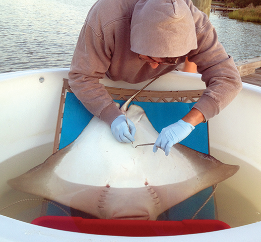
By implanting a small electronic tracking device in a cownose ray off Tilghman Island, Maryland, biologist Rob Aguilar and colleagues with the Smithsonian Environmental Research Center (SERC) can track the animal in the Bay as it mates, raises its young, and migrates to the coastal ocean. Photograph, SERC
WHEN DAVID SECOR GOES FISHING, he doesn't bring a pole or tackle box. He brings a laptop computer. He doesn't even look for fish in the water; he looks for them in black plastic cylinders about the size of a small kitchen fire extinguisher. These are underwater microphones that Secor and his research assistant Mike O'Brien hang in the water off buoys and bridge pilings in the Chesapeake Bay. These sensors listen for the telltale sounds of passing fish.
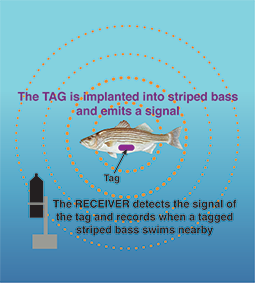
But not any fish. Secor is a fisheries scientist from the Chesapeake Biological Laboratory at the University of Maryland Center for Environmental Science, and he is angling for fish that he has previously caught, implanted with finger-sized electronic "pingers," and released back into the Bay. These gadgets emit chirps of sound into the water every 90 seconds that are coded to identify or "tag" each fish. If an electronically tagged fish pings within the range of one of his receivers, Secor can download it. If someone else's receiver picks up his fish, he can eventually recover that "detection" as well, though it will take time and effort.
This technology, called acoustic telemetry, is an important advance. It allows scientists, for the first time, to track individual fish as they move through their environment. They do not need to surface to be detected, as is the case for satellite tagging. By tracking fish in their natural element as they pass by and ping different receivers, researchers can ask important questions about fish behavior.
In the past few years, for example, this technology has helped Secor and O'Brien conduct a study tracking striped bass native to the Bay as some of them head for the coastal ocean on far-flung migrations. "We know that within a month or two after tagging a large striped bass in the Potomac River, it can be off Cape Cod," Secor says.
Acoustic fish tracking, in cases like this, offers valuable streams of hard-to-get data. Not just hard to get, but also a little too easy to lose. After all, fish taggers retire or pass away, but data should be forever. A lot of it, however, currently resides on hard drives on shelves and desks in the labs and offices of individual taggers. It worries Secor. "This is really precious data," he says. "If we don't have a place to put that data it could be lost forever. Which is awful."
Fish tracking in the Chesapeake is heading for a major technology leap that could protect the precious pings recorded by fish taggers and also reduce some of the drudgework and delay associated with sharing that data. The new tool is called the Mid-Atlantic Acoustic Telemetry Observing System, or MATOS. In essence, it's a database that could make it easier for scientists to collect, share, and safely store records of marine animal migrations in the estuary and coastal ocean. MATOS would also make it easier for federal resource managers to tap into fish-tracking data from across large areas of the coastal ocean.
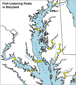
A network of underwater microphones (above, top) was installed in the Chesapeake Bay by David Secor and his partners with Maryland Department of Natural Resources. These acoustic receivers listen for the telltale sounds sent by transmitters (or tags) implanted in fish such as striped bass and sturgeon. Receivers are often placed in narrow waterways to be in broadcast range of tagged fish passing nearby. Map, courtesy of Mike O'Brien/Chesapeake Biological Laboratory; illustration (bottom), recreated by Sandy Rodgers from the original by the Fisheries Conservation Foundation, except the striped bass, which is by Duane Raver
To get to this brave new world of fish-following, trackers will have to upload their data to a distant computer via the web. And the architects of MATOS will need to assure these trackers that they can still control whom they want to share their data with -- and whom they don't.
Fisheries ecologist Matthew Ogburn of the Smithsonian Environmental Research Center is one fish tagger who sees the potential of the new tagging technology. "It's a very different way of doing research," Ogburn says, "but it also allows you to answer very different, larger-scale questions."
Fish Finders
Who is going to fund this expanded system? The seed money to develop MATOS came from the Atlantic States Marine Fisheries Commission, a state compact that works to manage fisheries sustainably. The other partners include the National Oceanic and Atmospheric Administration (NOAA) Chesapeake Bay Office, the Smithsonian Institution, and the Mid-Atlantic Regional Association Coastal Ocean Observing System (MARACOOS). The observing system is one of 11 regional organizations in the national Integrated Ocean Observing System (IOOS), a NOAA-led partnership of federal agencies, universities, and other organizations.
Tracking fish and collecting the data are time consuming and difficult, and that's where MATOS would help. The process starts when an acoustic receiver in the water picks up a ping and stores the time of detection and the unique identifying code of the tag that emitted it. This allows a researcher like Secor to recognize "his" fish. It's like the way the E-Z Pass electronic toll systems know to debit your account for a toll by detecting that little transponder stuck behind the windshield.
Every few months, fish taggers go out in the field to visit their receivers and download the data via a Bluetooth connection. This is where it gets complicated: the receivers pick up pings from any tagged fish that passes by -- not just those tagged by the owner of a particular receiver. So when Secor and O'Brien download from their receivers, they also capture fish "owned" by other taggers.
Taggers in the Mid-Atlantic region have developed a way to make sure everyone gets back their fish. It's a workable but not entirely user-friendly sharing system called the Atlantic Cooperative Telemetry (ACT) network, comprising marine animal taggers from Maine to Florida.
Rule One of the ACT network is that if you tag a fish, any data that results belongs to you. But getting your fish data back if someone else's receiver detects it is not always quick and easy. After O'Brien downloads the files from receivers and takes it back to the lab, he has to look up each "foreign" tag and its owner on an online spreadsheet that ACT members have access to on Google Docs. He emails the person and says in so many words, "I detected your fish. Should I send you the files?"
If the tag code is not on the ACT list, O'Brien has to email the data to Vemco, a Canadian company that makes the tags and receivers. They try to identify the owner and forward the contact information of whoever has the data. More emails ensue. Delays of months, known as "tag lag," are not unusual.
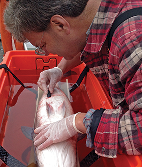
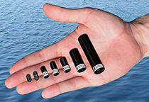
A range of marine animal tracking devices (above) called pingers or tags can be implanted in living fish, as fisheries scientist David Secor (left) has often done with striped bass in the Chesapeake Bay. The tags identify the individual fish, allowing scientists to track them as they move through their underwater environment. Some stripers are migrators: they breed, feed, and leave the Chesapeake for the Atlantic Ocean. Photographs, David Secor (left) and courtesy of VEMCO (right)
A Better Way?
Retired NOAA oceanographer Doug Wilson came up with the basic idea for MATOS and has been working since 2009 to allow taggers to transition from an informal sharing to a structured "database-driven" system. At the time, Wilson was building the Chesapeake Bay Interpretive Buoy System for the NOAA Chesapeake Bay Office, and had placed acoustic fish-tag receivers on the buoys that could report hearing a fish pinger immediately via its connection to the internet. "But we lacked a way to immediately identify the tag owners to provide them with the information," he says.
Wilson's goal is to help fish taggers maintain precise control over their data. His solution is to allow taggers to assign "permissions" to the digital files uploaded to the system from acoustic receivers. It will work this way: A tagger establishes an account on the MATOS database. He or she would enter the identifying code of their pingers into the system and designate who would have access to any detections of that tag -- colleagues they are working with on a project, for example. When anyone uploads receiver data, the time, place, and date of all the fish detected are then available in the database to those with permission to see them.
"It's sort of like fish telemetry Facebook," O'Brien says. "If I am working with you, I want you to see my data when I upload it." In other words, if you "friend" someone in MATOS, that person gets to see your fish; if not, the taggers can see only their own fish.
MATOS is still a demonstration project, overseen by MARACOOS, the Mid-Atlantic arm of IOOS. A prototype version of the tool is under development by the private company, RPS Applied Science Associates, that handles information systems for MARACOOS. Secor and O'Brien are working with the tool's developers to test the prototype, using some of their own data.
The winds appear to be blowing in the direction of database-driven tools like MATOS, according to Matthew Ogburn, who has worked with colleagues at the Virginia Institute of Marine Science to track cownose rays as far south as Florida. Tagging can also provide insights into the location of critical habitats and breeding areas. The shellfish-munching rays mate and give birth to pups in the Chesapeake in the summer, animal behaviors that acoustic tagging allows researchers to understand.
MATOS would also make it easier to combine fish-tracking data with information about water conditions collected by oceanographic observing systems. By doing this, fish biologists could gain insight into why fish and other marine animals do what they do. That opens the possibility of predicting where the fish are, a forecast which can inform policy decisions. For example, knowing fish migration routes would help planners choose sites for offshore wind farms with the least potential to impact marine animals. The same goes for planning shipping routes to protect marine mammals.
"If you are interested in preventing whales from being struck by ships, or if you are trying to find out what the best nursery habitat is for a species, or trying to look at migration routes, or how distribution of species will shift because of climate change, that's the real power of some of this tracking data," Ogburn says.
But first, the makers of MATOS will need to entice the diverse mix of animal tagging researchers into a centralized system. The payoffs will be worth it, says Carl Gouldman, deputy director of the NOAA IOOS program office in Silver Spring, Maryland. "It's going to be messy and complicated, but we're going to do it."
|