|
Those Dammed Old Rivers
The dam dilemma: tear them down to open fish runs or leave them up to block sediment flows?
Michael W. Fincham
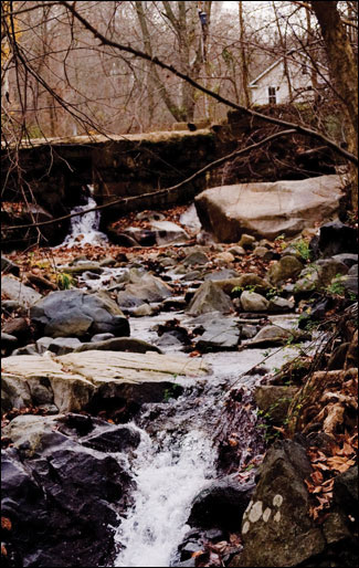
This small dam along Bonnie Branch run is a typical legacy of the early industrial era when dozens of dams, large and small, were built along the Patapsco and its small tributaries. Photograph: Michael W. Fincham.
IN 1761 A BUSINESS MAN named John Cornthwaite built a dam along the Patapsco River. Near a bend in the river now known as Ilchester, he had his workers lay a series of logs across the river and wedge them into rock outcroppings along the shore. The dam would supply water power for what seems to have been the first grist mill on the river. For reasons now unknown, it came to be called Dismal Mill.
For building his dam, Cornthwaite likely got help from the colonial Maryland government: in 1669 the general assembly had passed the Maryland Mill Act, an economic stimulus package aimed at encouraging the building of dams and mills. The act empowered Cornthwaite to backflood his millpond right over 20 acres of his neighbors' riverside property. Dam owners also got an 80-year license to use the river water, and this "water privilege," as it was called, could be sold or traded like real estate. For the loss of their land, the neighbors got below-market compensation.
His neighbors weren't the only losers in the deal. The Patapsco is a natural spawning river for species like alewives, American shad, hickory shad, river herring, and white and yellow perch. Unlike salmon these fish are not leapers, and not many would be able to make it over the dam at Dismal Mill. If any did, they would soon butt up against more dams.
Over the next two centuries, a string of dams would go up along the river as the Patapsco became one of the first focal points of the Industrial Revolution in Maryland. Those dams created water power for grist mills, saw mills, paper mills, cardboard mills, textile mills, as well as foundries and forges and hydroelectric plants. Towns would sprout up around the mills at places that came to be called Avalon, Orange Grove, Ilchester, Ellicott City, Oella, Daniels, and Oakland Mills.
Most of those dams and some of those towns are gone now, but migrating fish are still not swimming up the Patapsco, despite several efforts to open passage for them. Dams were abandoned as water power lost importance, then breached and broken as great storms sent famous floods roaring down the narrow river valley. At large concrete dams that survived those floods, fish ladders were erected with much publicity and high hopes for restarting the old fish runs. But not many migrating fish read the press releases, and hardly any of them ever managed to scale the ladders and reclaim their ancient privilege of spawning along the upriver reaches of the Patapsco.
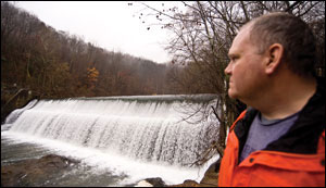
On the Patapsco River, Rich Ortt surveys Bloede Dam, currently a candidate for demolition. Decades after it stopped producing electric power, Bloede Dam blocks upriver passage for fish and poses a safety hazard for people. At least six deaths have taken place here in recent decades. Photograph: Michael W. Fincham.
Rich Ortt says he can see the river start to move right before his eyes. We're walking through a mid-November rain that's falling gently but steadily on the Patapsco River valley, and we're half a mile upstream from Bloede Dam, the last surviving dam on the lower river. The hillsides are russet with dead leaves and wooded with second-growth trees, their bare branches thinning into mist up along the ridge line. The river running through here is only inches deep, but the flow is growing stronger.
Ortt is not worried about water flow. He's focused on the sand-colored sediment along the bottom. "From this little bit of rain, the flow has probably gone up about 50 percent this morning," he says. "If you look at those sand ripples, you'll see the sand can move about two or three feet, and create these little sand bars."
Ortt is watching that shifting sediment along the river bottom because he's an engineer with the Maryland Geological Survey, and his job is to figure out where all this sediment will go if the Bloede Dam downstream is removed. The state has ambitious plans to take down the old dam and finally reopen much of the Patapsco's upriver spawning reaches. Those plans hinge, in part, on Ortt's findings. He points at the sand. "You actually see it moving."
What he's seeing raises a dilemma for those dam removal plans. Tearing down Bloede Dam may let fish swim upstream — but it may also let sediment flow downstream towards the Chesapeake Bay, an estuary already loaded and darkened with sediment. When I ask how much sediment's behind the dam, Ortt looks up at the gray heavens and pulls down some large numbers for me. Between 80,000 to 100,000 cubic feet. When that doesn't register with me, he tries an analogy. "Think 10,000 dump trucks full of sediment," he says.
You see the dilemma. Do you make a choice between fish runs and sediment flows? Or do you dig all that sediment out of the river before you tear down the dam?
"It's a real debate in the community," says Serena McClain of American Rivers, the nonprofit organization that's partnered with the National Oceanic and Atmospheric Administration (NOAA) to supply funding and technical assistance for taking dams down along the Patapsco and along dozens of other rivers around the country. Fish passage has been the driving passion behind a national dam removal movement that has helped bring down 470 dams around the country since 1999 — including 7 in Maryland. Sediment storage behind dams, however, is an issue in some proposed dam removals according to McClain, especially in Maryland where water quality is a major concern. "In the Chesapeake Bay watershed," she says, "sediment is a huge dirty word."
In late 2009, giant yellow excavators trundled into the Patapsco River several miles upstream of Ellicott City and began hammering at Union Dam and then loading the rubble into dump trucks. Already breached on one side, Union Dam had little sediment to hoard and what was there was simply released to flow downstream. In 2010 the heavy gear entered the river ten miles downstream near Ilchester and began battering Simkins Dam. Sitting just above Bloede, this private dam held an extensive backlog of trapped sediment. All that sediment was also set free to flow downstream.
Union and Simkins dams were experiments with a technique called "passive sediment release," a technique that may be tried for handling all the sediment now sitting behind Bloede Dam. Simply tear down the dam and let the river — and the sediment — run free. It's a lot cheaper than digging it out and trucking it away.
Early results suggest the experiment has worked — so far — in the stretch of river just below the demolished dam. "The sediment was really made up of this sand and gravel and really nice cobble materials," says McClain of American Rivers. Excellent habitat for migrating fish — if they could ever get here.
As a test of passive release, however, Simkins was a limited experiment. Much of its backed-up sediment simply shifted downstream and began massing behind Bloede Dam, just half a mile below. Built in 1907 as the world's first self-contained hydroelectric dam, Bloede is a larger dam where any "passive sediment release" would be a full-scale experiment. There are no more downstream dams between Bloede and Baltimore Harbor some five or more river miles downstream. And the sediment load moving downstream could be more than 10,000 truckloads.
Additional sediment, says Rich Ortt, could start coming off the land. He's now working a low stretch of woods that flank the riverside upstream of Bloede, trying to figure out what's under the ground he's walking on. If the dam comes down, will these woods stay put? Or will they wash away?
A big man, Ortt has broad shoulders and a broad open face that's half hidden under the hood of his red windbreaker as he trudges through the woods. He's leading a crew of three — all hooded or hatted against the rain — and together they look like a sect of monk-like druids performing some mysterious ritual among the trees. They take turns pulling a flat, white sled, and Ortt follows behind bearing a backpack that sprouts a long rod topped off by a disc-shaped antenna. The sled holds a ground-penetrating radar that shoots radio waves into the earth below and records the wave energy that bounces back. The disc antenna connects with unseen satellites to track their wanderings through the wet woods.
"We think this is a sediment bar," says Ortt, referring to this stretch of woodland. "But it could have been just a regular geologic bench." If there's a geologic bench (a bedrock formation) below us, then the land and the trees that have sprouted on the land will probably stay put. If this wooded ground is a sediment bar, however, some of it could end up in the river. Once the dam goes down, the river channel could drop nearly 26 feet below its current level, he says, and this deeper channel could undercut the stream beds, destabilizing the wooded ground where Ortt is working. "If this becomes mobile," he says, "this is more sediment than what's in the river."
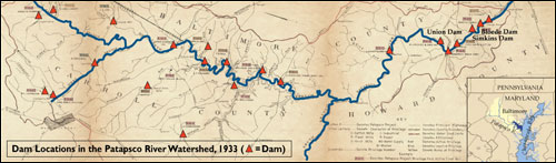
How many dams were built along the Patapsco may never be known. In 1933, engineers for the Office of Water Supply for Baltimore City tried to map all the existing and demolished dams in the Patapsco watershed. They found evidence for 28 licensed dams, many already in ruins, that once supplied water for grist mills, saw mills, cotton mills, woolen mills, water reservoirs, and early hydroelectric power. Many more had already disappeared completely, broken by great floods, like the storm of 1868, which washed away scores of dams from earlier, busier eras of dam building. Credits: Large map (adapted), courtesy of the Maryland Geological Survey; small map, Karl Musser.
What's the best option for all that Bloede sediment? Dig it up and load it onto trucks? Or try passive release and let it flow downriver towards Baltimore Harbor and the Bay beyond?
Questions like these make for spirited debates, according to those who've worked on the planning for dam removal. That planning process includes scientists from Johns Hopkins University, citizens from Friends of the Patapsco State Park, and experts from American Rivers, NOAA, and the Maryland state agencies responsible for natural resources, the environment, and geological surveys.
The debates can sometimes set biologists (who favor fish passage) against geologists (who worry about sediment loading). And they reflect controversies in the research community over competing theories about how rivers form in the Mid-Atlantic, controversies that set geologists against other geologists. The planners for Bloede Dam, it seems, will have to make a big bet on one theory or the other.
At the heart of the science debate is a newly expanded theory about legacy sediments left behind by old dams. Published in Science magazine in 2008, the findings come from Dorothy Merritts and Robert Walter, two geologists from Franklin and Marshall College who surveyed and studied hundreds of creeks, streams, and rivers, most of them in Pennsylvania. They suggest that many of the banks and floodplains bordering many Mid-Atlantic rivers are actually legacy sediment that silted up thousands of old millponds behind thousands of old dams.
Their theory tries to create a new paradigm for explaining how rivers formed in the Mid-Atlantic. In many valleys, the first dams — and there were a lot of them — were strung across marshy wetlands interwoven with small branching rivulets. So many dams were built so quickly that whole valley bottoms were transformed from wetlands to a series of linked slackwater millponds, lined up one after another. Those millponds filled with sediment, the dams were abandoned or breached, and the undammed water started cutting river channels down through terraces of land built on old millpond sediment. The end result would be the rivers we see today in many places: clearly defined, single strand rivers that meander through landscapes still littered with forgotten millpond sediment.
It's a compelling narrative that may have general implications for dam removals and river restorations. Robert Walter theorizes that the earth eroding off banks and adjacent lands adds up to a major chunk of the annual sediment load entering the Chesapeake Bay, a much larger chunk than previously realized. "The dams that were breached 100 years ago have a long-lived background of erosion that is still occurring," says Walter. "It is not a problem that is going to solve itself simply by blowing out the dams and forgetting about them."
"That article gained a lot of traction," says McClain of American Rivers. "It definitely divided the scientific community." And it did so just when Maryland planners were discussing releasing sediment from Simkins Dam into the Patapsco River. The key finding from Merritts and Walter was radical and important, according to Peter Wilcock, a geologist with Johns Hopkins University and an advisor to the dam removal team. "Nobody realized how much legacy sediment was due to dams that were no longer there," he says.
Some geologists, however, suggest Merritts and Walter may have overextended their theory in an effort to create a regionwide explanation of river formation based primarily on rivers in Pennsylvania. And one result was over-reaction, says Wilcock. "People are saying 'Oh my god, legacy sediment, we've got to dig it up. It's a loaded gun pointing to the Bay.'"
In Maryland, however, the dam removal team seems willing to bet against the new theory about legacy sediment. "Not all legacy sediment is dam sediment," says Wilcock. And not all sediment is bad for rivers. The planning team is, so far, making a bet on an older theory that rivers can reach an equilibrium, a theory based largely on rivers in Maryland.
In the 1950s Reds Wolman of Johns Hopkins University and Luna Leopold of the U.S. Geological Survey made numerous observations and measurements along rivers like Seneca Creek and Watts Run and Western Run, bringing a new quantitative rigor to river studies. They watched and measured how alluvial rivers were changing from year to year, how they were eating sediment off banks in certain spots but using it to build up other banks in other spots. Rivers seemed to have their own ways of handling sediment. According to Wolman, they could handle and adjust to slugs of storm-driven sediment that arrived every couple of years.
Their key finding: "The stream was wandering back and forth across the flood plain," says Wilcock. "And somehow it was keeping the same size and shape and slope and length." The river was authoring its own geometry. It was changing, but it was staying (almost) the same — just in a different place. Wolman and Leopold had a name for what the river was doing: it was creating a "dynamic equilibrium."
That's the theory McClain of American Rivers wants to bet on. "Equilibrium — that's what rivers do essentially," she says. "If you put in a dam, you're not allowing the natural transport of sediment. You might actually exacerbate erosion downstream because the river is hungry." A hungry river can start stealing sediment from the nearest shore.
Release the sediment flow? Or dig it up? Doing both, it turns out, is also an option. Most of the dammed sediment is sand that the river, over time, could handle. Sand could flow downriver and probably create new fish habitat. Buried behind the bottom of the dam, however, may be silts and clays, the finer grains that travel further and cause turbidity problems. "You may have to dredge that portion out," says Ortt, who plans on taking deep cores near the bottom of the dam.
With the Bloede Dam decision, whenever it comes, the dam removal movement in Maryland may reach a watershed moment. The funding for the Patapsco tear-downs came from the economic stimulus package of 2008 and from state agencies. In a twist of history, government help for building dams has morphed into help for tearing them down. For demolishing a big dam like Bloede, however, more money will have to be found — and a new stimulus package seems unlikely anytime soon.
If passive release proves too risky, if digging out the sediment proves too expensive, old Bloede Dam could keep aging in place. If it does, then all the work that went into removing those upriver dams won't yield much of a payoff for fish passage. A movement could lose its big moment. And some of its energy.
For now, Bloede remains the last dam holding sediment back from the lower river and the first dam blocking migrating fish from the upper river. Like a locked-up starting gate, it straddles the river near the spot where, in 1761, a businessman named John Cornthwaite first barred fish from racing up the Patapsco by laying down wooden logs to build a dam for his Dismal Mill.
|
