Ruined River
Photograph: One of a number of local rowing teams that practice on the Anacostia in the early morning light.
Contents
|
|
An Ecologist on the
Anacostia Watershed
Summer Students
Explore the Bay
A Blueprint for
the Bay's Future
|
|
|
This Issue's Videos:
Remembering theold Anacostia Planting the new Anacostia |

By John R. Wennersten
In the dawn light, sleek racing shells skim the surface of the water - against the summer green of trees on the far shore, this could be the Eastern Shore's Chester River or one of many rivers in Chesapeake Bay country. But this is the Anacostia, a more than eight-mile-long urbanized river that runs through the heart of Washington, D.C. - past the Navy Yard, Washington Gas and Light, and beneath four bridges within a mile of each other that carry thousands of commuters into and out of Washington each day. In the midst of all this commotion, natural and human rhythms persist - ospreys nest here, cormorants and blue herons feed along the shore, marinas are busy, fishermen cast their lines.
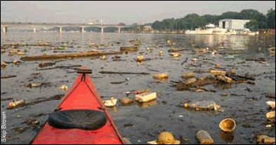
And yet, there are also the invisible realities of a river that the American Rivers Association has listed as among the most polluted in the nation. Fish advisories recommending limited consumption of fish from the river have been in place for many years - water quality is poor, especially because of bacterial contamination, and sediments are so degraded that the Chesapeake Bay Program has designated the Anacostia, along with Baltimore Harbor and the Elizabeth River in Norfolk, as one of three Regions of Concern in the Chesapeake.
The bacterial and contaminant assaults that have brought the river to such a low ebb come from a number of problematic sources, including combined sewer overflows, discharges of wastes and runoff of heavy metals and toxic compounds directly to the main stem. The Anacostia is also at the mercy of freshwater flow that brings with it sediment and a stew of heavy metals and organic compounds such as PCBs and PAHs.
This means that any plan for realistically joining the river to a measure of health depends on bringing together resources not only across jurisdictional lines in the District of Columbia and Maryland's Montgomery and Prince George's counties, but also among federal agencies, scientists, legislators, industry and civic organizations such as the Anacostia Watershed Society.
The stakes are high. In the words of Tom Arrasmith, who chairs the Anacostia Citizens Advisory Committee, "We can't build a prosperous community on top of a ruined river."
A History of Assaults
The history of the Anacostia River, like many urbanized river systems, tells a complex tale of interaction between the land and its people. Centuries of development in the watershed have led to runoff of soils, waste disposal, industrial discharges and increasingly, a host of toxic compounds that end up in the sediments and remain there. Since the 1980s, government agencies, civic groups and other organizations - among them the Anacostia Watershed Restoration Committee, the Anacostia Watershed Toxics Alliance and the Anacostia Watershed Society - have formed to try to reverse the river's decline. Scientists have worked together with federal and local agencies to identify sources of contaminants, the extent of their presence and their dynamics in the river. The goal is to develop science-based strategies for curbing those sources, remediating the legacy of contaminants that years of abuse have left behind and making waters healthy enough so that by 2010 - the timetable set by the U.S. Environmental Protection Agency - they are fishable and swimable.
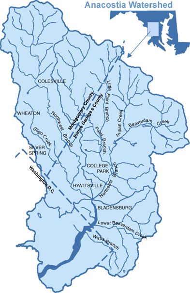
The Northeast
and Northwest branches in Maryland account for more than 70 percent of the freshwater flow into the Anacostia and are a conduit for sediments, trash, heavy metals and organic compounds.
A laudable goal. However, given the legacy of toxics in the river, continuing runoff from the land, and shoreside development still on the rise (more than 30,000 new residential units over the next 25 years according to the District of Columbia's Office of Planning) how realistic is that goal?
The poor state of the Anacostia is hardly new. "We have spent a long time destroying the watershed," says Cameron Wiegand, watershed manager for Montgomery County's Department of Environmental Protection. That destruction began at least as far back as Colonial settlement in the early 1600s when tobacco growers first cleared the original hardwood forests to grow tobacco and other crops. A major port soon followed at Bladensburg, Maryland, at the upper reaches of the river, for shipping tobacco abroad. By 1720, water quality problems stemming from its unprotected shorelines were already occurring in the Anacostia.
Early on, farmers tried to curb erosion from their plantations by constructing dikes along the shore - their efforts failed and by 1830 the main channel had become so silted in that commercial ships could no longer sail upriver to Bladensburg. Over the next 50 years, development along the river continued to expand, eventually including industry, the Navy Yard and housing and businesses to support a growing population. One consequence has been a 90 percent loss of wetlands - buffers that could help trap sediment runoff and contaminants. At the same time, the river has also been on the receiving end of heavy upstream flows.
The mainstem of the Anacostia begins at the confluence of its Northeast and Northwest branches, which together drain dozens of creeks in Prince George's and Montgomery counties. These two branches account for more than 70 percent of the freshwater flow into the Anacostia - they are a conduit for sediments, trash, heavy metals and organic compounds that eventually wash into the main stem of the river.
Naturally slow moving, the river is an inevitable sink for contaminants that have accumulated for years in bottom sediments where they are recycled over and over again by storms and taken up in foodwebs - for example, by fish that feed on contaminated bottom-dwelling organisms. If these legacy contaminants were the only problem, the potential for containment by capping them with non-toxic soils or removing them by dredging might greatly improve water quality. But the Anacostia, like so many river systems, is still on the receiving end of bacterial pollution and toxic chemicals - through land runoff, sewer overflows (on average, raw sewage flows into the river every three days), groundwater and airborne deposition.
Management Begins with Science
Researcher Margaret Palmer is well acquainted with the many ways that water finds a path to the Anacostia - and she argues that the fight for the Anacostia needs to take place both upstream and downstream. A professor of biology at the University of Maryland and recent recipient of an Ecological Society of America's Aldo Leopold Fellowship, Palmer leads a national task force called the National River Restoration Science Synthesis Project. Sponsored by American Rivers and other partners, this task force draws on the expertise of freshwater ecologists and others to focus on the restoration of streams and rivers across the country, including the Potomac and the Anacostia. Palmer knows that the Anacostia's problems begin in the many streams that drain Prince George's and Montgomery counties, and she is trying to figure out what to do about it.
"We cannot rely on just what's left," she says, speaking of the remaining buffers and wooded areas in the watershed. She also adds that even healthy buffers may not help, if a watershed is highly developed. She points to places in the Northwest Branch and Paint Branch where GIS maps show stormwater pipes penetrating buffers. In those cases, she says, while a buffer can still provide shading and other benefits, it will do little to slow the inflow of stormwater.
"We need to join together channel restoration and land use planning," she says. Palmer has worked hard to link her studies of stream ecology with the needs and plans of managers in the watershed. She notes that there is more uncovering or "daylighting" of streams, and that more people are beginning to understand that natural features - such as fallen trees - are actually good for a stream and part of its ongoing cycling of nutrients. (See sidebar: "An Ecologist on the Anacostia Watershed.")
By keeping stormwater on the land, natural hydrological processes associated with grasses, trees and soils can filter out pollutants.
But what can be done about toxic chemicals and other contaminants that have already arrived in the Anacostia? Answering this question requires finding those contaminants, measuring their concentrations and analyzing their biological impacts. David Velinsky is one of a number of scientists who have been tracking contaminants in the Anacostia's sediments and water column, measuring concentrations of PCBs (polychlorinated biphenyls), PAHs (polyaromatic hydrocarbons) and heavy metals, charting their movement through food webs, and especially, their impacts on fish and ultimately on human health. A scientist with the Academy of Natural Science in Philadelphia, Velinsky's findings, and those of Gerhardt "Fritz" Riedel (also of the Academy) and Fred Pinckney and Beth McGee of the U.S. Fish and Wildlife Service, have gone a long way toward detailing what we know today about the nature of contaminants in the Anacostia. They found that:
- Contaminant hot spots occur in the tidal Anacostia as a result of downstream flow from Maryland, together with specific sources to the river such as combined sewer overflows and runoff from the land occurring throughout the entire stretch, including the District of Columbia.
- Analysis of sediment grain size correlated with chemical contaminant data indicate that most of the sediments (perhaps 90 percent) entering the Anacostia from the Northeast and Northwest branches in Maryland are retained in the lower portion of the river.
- High levels of PAHs correlate with cancerous skin and liver tumors in brown bullhead catfish (Ameiurus nebulosus).
The knowledge gathered by these and other researchers is providing "hard-edge" numbers that modelers such as James Collier of the District of Columbia Department of Health and Cherie Schultz of the Interstate Commission on the Potomac River Basin need in order to refine mathematical simulations of sediment and toxic movement in the Anacostia. For example, says Schultz, "we took a toxics-transport model and tried to predict the patterns that Velinksy observed."
If such models could predict observed concentrations of PCBs, PAHs and other contaminants under different rainfall and waterflow conditions, then resource managers could play what-if scenarios - for example, if sediment flow at the head of the river were reduced by a certain volume, how much would that reduce PCB or PAH loading at so-called "hot spots" farther down the river?
Mathematical models are only as good as the data that go into them - that's why measuring concentrations of contaminants under different flow conditions remains so critical. "They provide the calibration data for the models," Velinsky says. In October 2002, he explains, there was "a perfect storm" in the Washington area for taking a suite of measurements - he and his colleagues collected samples before and during the storm and eight days afterwards.
How good are the model predictions? We still have a ways to go, Collier admits - it's one thing to do a model, he says, another to use it in cleaning up the river. We still don't know exactly where the PCBs are coming from, he says, or how much is coming from runoff, combined sewer overflows, groundwater and airborne deposits. While the model cannot "partition" the sources of PCBs among these different sources, there is also a difficulty in getting enough accurate measurements. The kind of high quality work that researchers like Velinsky are doing, says Schultz, is very expensive. "This means there is very little data. We're trying to use data from three or four storms - consequently our results are based on numbers with large uncertainties."
Despite these uncertainties, both the research and the models are providing new information that agencies can use to try to make a difference. The question remains, however, how will resource managers prioritize, how will they determine what to go after.
"If we did business as usual, we would never be able to completely characterize an area and therefore would never be able to begin any clean-up actions in the river," says Nick DiNardo of the U.S. Environmental Protection Agency. DiNardo is a member of the Anacostia Watershed Toxics Alliance, which represents 25 different agencies, institutions and community groups. A voluntary public-private partnership formed in 1999, the Alliance works to take directed action on toxic problems.
"We have legacy contaminants and ongoing current sources - the combination is contributing tremendous loads of contaminants to the sediments and waters," says DiNardo. "With any hope of realistic remediation in a reasonable time," he says, "we have to come up with approaches that draw on the resources of all our stakeholders working collectively."
Using measurements and current models, about a half-dozen PCB hot spots have been identified in the main stem, DiNardo says, including one around Kingman Island on the east bank. According to DiNardo, there was no apparent source for contaminants, until the Park Service identified a landfill, which could be the culprit. The Park Service will try to shut off any flow from the dump, says DiNardo, by isolating the landfill so that groundwater will go around it. At the same time, he says, "we want to try to stabilize the hot spot itself so that PCBs in the sediment are not released back into the water. One way is to cover the hot spot with a "reactive cap," a somewhat permeable material that should degrade PCBs moving through the cap material.
In a pilot project, several types of capping materials will be compared for their effectiveness. What is the prospect for success if PCBs are still entering the river and, because of flow dynamics, settling into the hot spot? Though there will still be PCBs coming in even if the Park Service is successful in reducing PCB flow, answers DiNardo, the hope is that their concentrations would be much smaller because the reactive cap should not only degrade contaminants below, but also new deposits of contaminants that settle on top of it.
|
|