|
New Technology
Eyes on the Bay
By Jack Greer
Keeping track of the Chesapeake is no mean feat. All too often now the estuary's mix of tides, currents, seawater, and rainwater make for a dreary dance of harmful algal blooms, sediment, and low oxygen levels. How can managers and citizens keep up with that constant change, to know where things are getting better, where they are getting worse?
To help us keep track, Maryland (in 2002) and Virginia (in 2003) launched continuous monitoring efforts. Now anyone with Internet access can keep tabs on oxygen, turbidity, and other vital signs.
Data specialist Mark Trice heads up the Maryland Department of Natural Resource's Intensive Monitoring Assessment and Development Program and has played a key role in developing Maryland's Eyes on the Bay. He says the effort built on continuous monitoring efforts that dated back to the Pfiesteria events of 1997 — when blooms of a tiny dinoflagellate incited concern over water quality and public health. Stations set up in the Pocomoke to closely monitor conditions at the time demonstrated the effectiveness of the method.
Continuous monitoring — real time or near-real time tracking of water quality — took its first flights on the wings of new technology back in the 1990s. The first technical tool, called DataFlow, allowed small boats to pull samples through an intake hose and analyze them, all while underway. The second used fixed monitoring stations that gather data at regular intervals — say, every fifteen minutes. These innovations feature devices like windshield wipers that regularly swipe sensors clean — important in the Bay's productive soup, where almost anything becomes fouled fast.
Even at that, Trice says, they have to pull the fixed monitors every week or two to clean them and recalibrate them, a time-consuming task.
As of 2007 there are some 50 fixed monitoring sites in Maryland's portion of the Bay, and about a third of them stream information for instant access. Virginia deploys more than 30 fixed stations, as well as areas monitored by small boats underway.
These intensive monitoring programs, developed in cooperation with the regionwide Chesapeake Bay Program, got going at about the same time that the U.S. Environmental Protection Agency (EPA) published new water quality standards for turbidity, chlorophyll, and dissolved oxygen. The drive to get the Bay off the EPA's list of impaired waters has made this kind of accurate water quality monitoring essential throughout the Chesapeake and its rivers. Plans are underway to link these systems with other regional observing systems, which are in turned linked to national and even global observation systems.
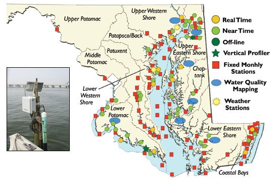
Fifty fixed stations, like the Sandy Point site above, keep a constant watch on water quality in Maryland. On the web an interactive map links users to a wealth of information. This map (right) shows stations on the Bay during summer 2007. Maryland Department of Natural Resources.
|
For Further Information
Eyes on the Bay
Virginia Estuarine and Coastal Observing System (VECOS)
The Chesapeake Bay Observing System (CBOS)
Maryland's BayStat
Chesapeake Bay Remote Sensing Program
Monitoring the Bay from Above
- Snapshots of the Summer of 2007
-
Chesapeake Bay Program's Monitoring and Analysis Subcommittee (pdf)
-
Chesapeake Bay Foundation Bad Waters Report
|