By Erica Goldman with reporting by Alison Kahn
|
|
"I looked down the gutter there and saw my desk drawer floating by, and I thought, that's probably not a good sign. THis is the desk that I put p on sawhorses inside the building. And there was my stuff in the drawer, just floating down the gutter."
— Jeff Holland
|
When Jeff Holland closed the doors to head home for the night, he thought that he'd done all he could to secure the Annapolis Maritime Museum against the approach of Hurricane Isabel. The museum director and his staff had moved all of the museum's artifacts and records upstairs, securing them on the second floor under a tarp. They placed furnishings and big items, like a large-scale model of the Thomas Point lighthouse, up on sawhorses, expecting high water to come and go. On the museum dock, Holland flipped all the picnic tables face down, diligently drilling and bolting them into the wood surface. If the tide topped the dock, floating picnic tables might hurt someone.
But the picnic tables did not float away. When Holland located them the next day, the tables were still well secured, still bolted. What he had a hard time finding was the dock itself. He never suspected that Isabel's nearly 8-foot storm surge, piled on top of the normal high tide, would lift the entire dock, smash it into the building, and drop it at the end of the street.
When Hurricane Isabel slammed the Mid-Atlantic region as a Category-2 storm on September 18, 2003, the impact of the storm caught everyone — even many experts — by surprise. With its eye located just south of the Chesapeake Bay, the storm took 23 lives and brought widespread flooding that damaged buildings and washed away homes. What made Isabel so destructive? Should we expect to see more such storms in the future? If so, could a warming climate be to blame?
Surge of Rising Seas
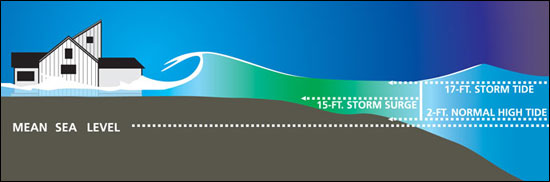
Wind and waves gave Isabel its hefty punch. During a hurricane, low pressure and high winds create a large dome of water — a storm surge. Topped by wind-whipped waves, this giant dome, often 50 to 100 miles wide, combines with the normal tide, producing what is known as a storm tide. If the surge reaches the coastline at high tide, as it did in Annapolis during Isabel, the water can top an average high tide by many feet. "And it only takes a 1-meter wave to knock down an average house wall," says Rick Murnane, a program manager for the Risk Prediction Initiative (RPI) — a science-business partnership based at the Bermuda Biological Station for Research.
The risk posed by storm surges is further exacerbated by rising sea levels, a global problem that is tied to the warming of Earth's climate. Higher sea levels encourage the formation of larger waves that break close to shore. Because the Bay is so shallow, just 1 foot of sea level rise causes a big increase in waves, explains geographer Michael Kearney at the University of Maryland College Park. In addition, sea level is rising at a rate nearly twice the global average in the Bay region, 3.5 millimeters per year. This extra inundation results from the fact that land in this region is simultaneously sinking (see Footprints of Global Warming).
A warming atmosphere, due in part to greenhouse gas emissions, will continue to raise ocean temperatures, causing the surface of the ocean to expand, explains paleoclimatologist Thomas Cronin, at the U.S. Geological Survey in Reston, Virginia. This expansion serves as a major contributor to global sea level rise, he says. But the melting of the great ice sheets in Greenland and Antarctica, along with the world's glaciers, may also play a huge role, a factor that has become "scarily apparent" in the past three to four years, says Cronin.
Picture an ice cube sitting on the edge of your bathtub, Cronin says. When that ice melts and flows into the bathtub, it will raise its level. This is what will happen as the ice sheets melt because they sit on land, not water. If the Greenland ice sheet were to melt, for example, it could cause an additional 6 to 7 meters of sea level rise globally, says Cronin.
Even in the absence of storms, global sea level rise, sped locally by the Bay's sinking shores, has already affected the Chesapeake. The Bay has lost many islands and marshlands to this combination of sea level rise and subsidence and stands to lose more still. Court Stevenson, an ecologist at the UMCES Horn Point Laboratory who works to preserve marshland, advocates physically rebuilding areas by relocating sediment to counteract the forces that threaten to destroy this critical habitat for crabs and juvenile fish.
Unfortunately, says Stevenson, we are "applying band-aids to stop hemorrhaging." The real changes need to be made in reducing carbon dioxide emissions, he says, but if "we do nothing at all we stand to lose a tremendous resource."
Another part of the problem stems from the high growth rate in the Chesapeake region. A 2005 report from the National Oceanic and Atmospheric Administration ranked the Chesapeake Bay watershed as the second most populated coastal watershed in the country and Maryland and Virginia as "hot spots" of growth. Growth puts pressure on sensitive coastal areas and, as Kearney points out, there is no real plan to account for sea level rise in planning for development.
According to Brent Yarnal, "In every place we've looked, infrastructure tends to be clustered in very vulnerable areas." A geographer at Penn State University, Yarnal worked with the Bayside community of Hampton Roads, Virginia on this overlooked intersection of storm surges, sea level rise, and coastal development. He used a model called SLOSH (Sea, Lake, and Overland Surges from Hurricanes) to evaluate how rising sea levels could increase the reach of storm surges into 16 counties in Hampton Roads and the surrounding area. The model allowed him to explore different scenarios — like the impact of a hurricane if sea level were to rise by 1 foot versus 3 feet and the effect of population growth in the region.
Yarnal then used census data, such as age and poverty, and information about the placement of critical infrastructure, such as water and sewer, to construct a "social vulnerability index" for the community. He's now working with local planners to incorporate projections for worsening storm surges into plans for future development. "When it comes time to replace that infrastructure," he says, "all planners really have to do is think about moving out of the risk zone and building it in fairly secure places. Higher ground."
Stronger Storms in Store?
The climate connection between rising sea levels and worsening storm surge may just be the tip of the (melting) iceberg. Over the past two years, a flurry of scientific papers has also established a link between warming global climates and the intensity of tropical storms.
Since 1970, the number of Category 4 and 5 hurricanes has increased by 80 percent, with the most dramatic increase occurring in the past ten years. According to a paper published in Science in September 2005 by meteorologist Peter Webster from the Georgia Institute of Technology in Atlanta, this increase in hurricane intensity correlates with rising sea surface temperatures worldwide.
In a complementary study, meteorologist Kerry Emanuel from the Massachusetts Institute of Technology evaluated the intensity of a storm relative to its duration, calculating a measure known as the "power dissipation index." Publishing these results in an August 2005 issue of Nature, he found that this index — and therefore storm intensity — has increased dramatically since the 1970s. He also found that this increase correlates with global warming trends. Emanuel's results suggest that continued warming would further increase the destructive potential of storms that, especially given growing coastal populations, could make hurricane-related losses even worse.
Is it possible that warming ocean temperatures and intensifying storms are part of a natural cycle of increased activity rather than the result of human influence? Not likely according to a collaborative study published earlier this year (September 2006) by Benjamin Santer and others in a Proceedings of the National Academy of Sciences. This study found that human-caused greenhouse gases are the main driver of the 20th century changes in sea surface temperatures now linked to intensifying storms.
Scientific evidence points convincingly to the possibility of stronger storms as the 21st century unfolds. For the Chesapeake region, rapidly rising sea levels make the specter of such storms, and the storm surges they may bring, even more threatening to coastal communities.
Confronting the future with eyes wide open, by incorporating predictions for climate warming and sea level rise into model projections and community planning, seems the best defense against a potentially tempestuous future.
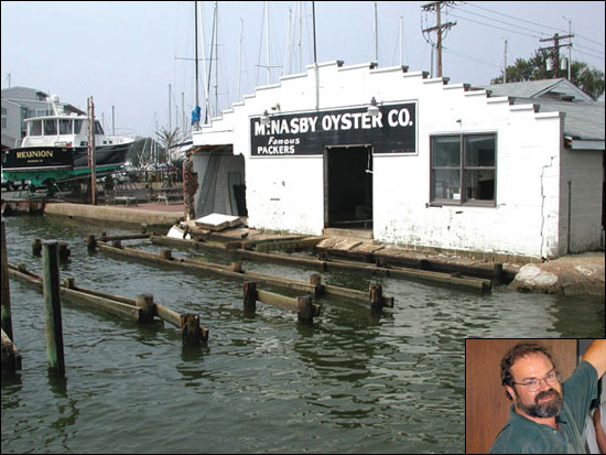
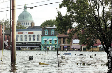
Hurricane Isabel, September 18, 2003 left downtown Annapolis underwater (opposite page) transforming a street usually packed with tourists into a flooded mess.When the storm surge, created by the hurricane's high winds (above, bottom, by NOAA), arrived, waves crashed over the top of the Annapolis Maritime Museum, located in the former McNasby Oyster Company packing plant (above, top, by Annapolis Maritime Museum). According to museum director Jeff Holland (right inset, above top, by Annapolis Maritime Museum), debris in the waves acted as battering rams, making big holes in the side of the building.
|
![[Maryland Sea Grant]](/GIFs/h_footer_mdsg.gif)