|
|
|
We're nearing the upper edge of the Virginian Sea Trench when Captain Pedersen, master of the Taiko, decides he has seen enough of this pilot.
Van Metre will soon come up against the Rappahannock Shoals, the largest underwater shallows in the Chesapeake, but the sea captain is finally comfortable giving up the bridge. He has seen Van Metre maneuver through three channels and pass one ship. "I have an old pilot who has been there before," Pedersen says, standing by the exit door. "I go down and take some paperwork." And perhaps some sleep.
With the captain below, Van Metre swings sharply west by northwest into the Rappahannock Channel, a 14-mile furrow that cuts through the Rappahannock Shoals. There are no natural troughs around this huge, Baywide hump, and no satisfactory explanation for why it's here. Van Metre runs the channel on a 322 compass heading, adjusting for drift from an ebb tide that's pushing against the hull.
At the end of the shoals, Van Metre calls for Zero-Zero-Zero: We're headed due north up the Deep Trench, the long paleo-channel- dug out by the Susque-hanna River during the last ice age. Here the Bay bottom drops away to depths of 100 feet and more. We're not halfway to Baltimore yet, but the Deep Trench, long and straight, has the look of the home stretch at the Preakness. And Van Metre, the ship jockey, takes a gentle whip to his big horse, asking with his courtly manners for more RPM. The Taiko slowly ramps up to 19 knots.
Van Metre gets through nights like this with coffee and conversation. The first mate from Norway tells him about rehabbing the Taiko in China. Van Metre tells him about fishing Eastern Shore rivers with Indian names and watching dozens of oyster buyboats stacked high with harvest. The bridge radio crackles with tugboat talk, some of it drifting down the night from Delaware Bay.
As the night deepens and he rides yet another ship up the Trench, one of 4,000 or more ships he's piloted, he thinks also about retirement — climbing down the Jacob's ladder for a last time. "It's a big decision. You do something all your life," he says, "and then you look at the rest of your life and decide what you want to be doing with it." Fishing, gardening, raising Japanese koi fish, watching more lacrosse, the game he played at the University of Maryland — these are some of the things he would be doing. But what does he do with all those buoys and lights and channels he carries around in his head?
In the gray pre-dawn, the Bay Bridge is a dim skeleton asleep in distant haze. By the time the Taiko cruises under it, cars and trucks are crossing above us, headlights on, early morning drivers off to work. In the wheelhouse of a Ro/Ro carrying even more cars to Baltimore, Van Metre gets ready to finish his work day. Just north of the Bay Bridge he starts the Taiko through the last, tricky stretch: the Baltimore entrance channels.
Seven channels in all, some named for the engineers who dug the trenches: four Craighill channels, the Brewerton channel, then Fort Carroll, and finally the Fort McHenry Channel leading under the Francis Scott Key Bridge — a series of linked cuts that allows Van Metre to squeeze his big ship through shoals built up by the unending sediment flows washing down the Patapsco and Susquehanna rivers.
Because of these channels, Baltimore is still a port city. In the 18th century, Van Metre would have been piloting ships upriver to Joppatown and Georgetown, Bladensburg and Upper Marlboro and Piscataway. All were busy seaports, but all clogged up and closed down shortly after the arrival of deep plowing and deforestation. The first age of plowing, like the last age of ice, altered the evolution of the estuary — as did the building booms of the 20th century that raised so many cities, suburbs, shopping centers, and highways and flushed so much earth down towards the Bay.
Whatever washes into these channels the Army Corps of Engineers has to dredge out. They've been working the Baltimore channels since 1836 when the controlling depth was 17 feet, and Con-gress decided it was in the national interest to have one major port in Mary-land. The channels deepened in small chunks, growing finally to 50 feet deep and 800 feet wide in most cases. Most of the dredging money came from the federal government. Most of the dirt dredged out of these cuts came from the farms of Pennsylvania.
The master of the Taiko is back on the bridge, bright-eyed after a couple hours sleep. Captain Pedersen got his wish — Baltimore by dawn — but he's still a man in a hurry. His next goals are the port of Savannah, a flight home to Norway, and the start of a four-month vacation. What does a ship captain do with his time off? "Travel," he laughs. "Everything."
He's working his binoculars, checking out the early morning sights — after 10 days of empty ocean, this is his first city. The sun, still low, has burned off the haze and great slabs of light are falling on the smoking towers and shipyards and steelworks at Sparrows Point. From the smokestacks to the north, from the cooling towers to the south, pillars of steam bracket the channel, opening a bright gateway to Baltimore.
For a moment, it's a gateway back in time. Steaming under Key Bridge is the Guadalajara, an old fashioned freighter gliding towards pilot and captain like a vision out of the past. A high-strapping bow, swooping back to a cargo deck with derricks, and a tall superstructure beyond. "It looks like 1970 again," says Van Metre. Both veterans are working the binoculars now. This is what ships looked like when both were young and working their way up the old ladder from deckhands to ship drivers. "They don't build them like that anymore," says Pedersen.
Van Metre's passage ends just inside the Key Bridge. A docking pilot is already making his way up the Jacob's ladder. For pilots working the Bay out of Baltimore, the bridge is the gateway out, the gateway home. For Van Metre it's the site of his worst nightmare, the one thriller he has to tell me.
He was taking a container ship out of Baltimore for a night run down the Bay. The year was 1980, the ship was the TFL Freedom, a name that rings in his mind after 25 years. He had the ship up to 11 knots, picking up speed, headed for Key Bridge, when everything failed: power, lights, steering. It's called "losing the plant," and it can bring disaster in a port or a close ship-to-ship passing — or a bridge approach.
Standing in the wheelhouse in the darkness, Van Metre had 30,000 tons in motion headed for an immovable object. And all he had to work with was his own hand-held radio, his shiphandling and his judgment.
His only hope was the ship's anchors, but that's a tricky, one-shot chance. If he lets the anchors out too soon while the ship is moving too fast, they will run all the way out and break free from the windlass. The anchors are gone and the ship is still moving. If he waits too long, he may not have time to stop the ship from smashing into the bridgeworks. If he drops the anchors in shallow waters, they may tear a hole in the bottom of the boat. He has to judge the speed by eye, the distance by eye, and the channel by memory.
And he has to be prepared. Because he was leaving the dock, he had a man waiting forward by the anchor, a safety precaution. Then he had to wait, watching the water for speed, watching the bridge for distance, watching for his one shot. When he ordered the anchors let go, he waited some more, hearing them clank overboard, waiting for them to bite the bottom, waiting for the brakes to grab — and not break.
He brought the Freedom to rest just short of the bridge. He was, at the end, looking almost straight up at the bridge, seeing the nighttime traffic humming above him. It remains, he says, his most terrifying experience. It's why they pay pilots well.
With the Taiko in the harbor, Van Metre gives up the bridge quickly. A brief conversation with the docking pilot. "Dead slow, Merrill, we're 7.2 knots, bow and stern thrusters working, 30.6. Okay?" Tall and light-haired, Captain Merrill Brunson will handle docking duties, using tugboats to muscle the Taiko up to the pier.
Van Metre and Pedersen shake hands, both courtly and polite and pleased with their trip, both headed home. Walking with the chief mate, Van Metre starts the long descent down elevators and stairwells to the pilot platform.
Then down again, holding the ropes, hitting the wooden treads, working his way down the years to a waiting pilot launch, the kind of boat where he began his career. Stepping lightly on the launch, he looks up, waves and lets go of the ladder.
Ship Shape for the Future?
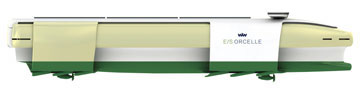
A zero-emission ship? That's the daring concept from Wallenius-Wilhelmsen, the progressive partnership of two historic- Scandanavian companies. The Wallenius Line began in Sweden in 1934 with one small coastal tanker carrying vegetable oil. The Wilhelmsen Line began earlier with less, starting in Norway in 1861with part ownership of one ship. Joined in 1999, these family-owned companies now operate more car carriers and roll-on/roll-off ships than any company in the world.
The E/S Orcelle represents their vision for the future. Named for an endangered dolphin, it has a streamlined shape, tall sails, solar cells and five long slender hulls that create energy out of ocean waves. No engines, no burnt hydrocarbons, no ballast water: zero emissions.
It's a ship of ideas that may never be built in its entirety, according to Wallenius-Wilhelmsen, but its design elements should start showing up in their future ships. Let's hope the cars they carry will also be zero-emission.
For More Information
The Chesapeake Bay Pilots. 1953. M.V. Brewington. Maryland Historical Magazine 48:109-133.
Chesapeake Invader: Discovering America's Giant Meteorite Crater. 1999. C. Wylie Poag, Princeton University Press.
The Life and Death of the Chesapeake Bay. J.R. Schubel. 1996. Maryland Sea Grant College.
Baltimore Harbor: A Pictorial History. Robert C. Keith. 2005. The Johns Hopkins University Press: Baltimore and London.
Minding the Helm: Marine Navigation and Piloting. 1994. The National Academy of Sciences.
Ancient Channels of the Susquehanna River beneath Chesapeake Bay and the Delmarva Peninsula. 1990. Steven M. Colman, Jeffrey P. Halka, et al. Geological Society of America Bulletin 102 (September):1268-1279.
Effects of Soil Erosion on Navigation in Upper Chesapeake Bay. 1945. L.C. Gottshalk. Geographical Review 35 (2/April):219-238.
The Chesapeake Meteorite, Message from the Past. U.S. Geological Survey, meteor.pwnet.org/impact_event/impact_crater.htm
Maryland Association of Pilots, www.marylandpilots.com
American Pilots Association, www.americanpilots.org
|
|
|
![[Maryland Sea Grant]](/GIFs/h_footer_mdsg.gif)