Big Picture
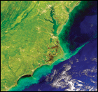
Photograph: The Bay's mosaic of land and water, seen from the DeHavilland Beaver that for years carried remote sensing instruments up and down the estuary, gathering data. By Larry Harding.
Contents
Monitoring the Bay
from the Air
|
|
Workshop Report:
Remote Sensing
Needs in the Bay
Scientists Weigh in on
Blue Crabs
|
|

By Jack Greer
To understand the rich mix of the Bay's algae - its primary producers - one must be able to track shifting populations up and down the estuary as they respond to changes in nutrient levels, weather conditions and river flow.
The engine of the Piper Arrow whines up to 2000 rpm. The pilot throws a switch and throttles up again, the plane shuddering on the runway with the force of the single propeller, its brakes locked tight.
"You have to check out both magnetos," the pilot says, "in case one of them stops working while you're in the air. That's what fires the spark plugs."
This seems a very good idea.
With redundant systems checked out, the pilot releases the brakes, and the Piper's spinning prop pulls us along the runway. Always, when a plane takes off, there is a sense of escape, of slipping off a shackle you didn't know was there, and in a small plane the effect is even greater, the sense of risk keener.

A single engine airplane that gathered data using the Ocean Data Acquisition System (click on the thumbnail for an enlarged view).
Pushing the throttle farther forward, the pilot coaxes the plane into a breakneck pace, as it races directly for a small gap in a line of trees. Long before we get there, the wheels have left earth, the small airfield has begun to drop away, and we are over Beards Creek and climbing fast. The pilot appears relaxed, confident, having done this many times before.
The pilot at the controls of this small private plane is Larry Harding, a researcher at the University of Maryland Center for Environmental Science who has spent two decades and most of his career studying the Chesapeake Bay from the air. He keeps his private plane at Lee Airport, located on the shores of Beards Creek way up the South River and one river south of Annapolis, Maryland. From here a plane quickly reaches the Bay near Thomas Point lighthouse, and then in a matter of minutes is winging over the Eastern Shore.
From his seat high in the air Harding can see the low-lying patchwork of creeks and inlets that define the Bay's drowned landscape. He can also see the way the color of the water changes, shifting shades of blue and green and brown. At times clear lines appear like sharp borders between tidal currents heading in and out of the Bay and its rivers. In this mix of currents and color Harding can see, especially in late spring and summer, dense blooms of algae, fed by nutrients from the land but also driven by the caprice of currents and by the principal power behind photosynthesis, the sun.
"People often talk about nutrients causing algal blooms," Harding says, "but that's not the only factor."
The tiny plants that lie at the base of the Bay's food web - what scientists like Harding call primary producers - depend on a particular recipe of nutrients, water chemistry and sunlight. Take away sunlight - during stormy, cloudy periods, for example - and photosynthesis falls off.
To understand the rich mix of the Bay's algae - its primary producers - one must be able to track shifting populations up and down the estuary as they respond to changes in nutrient levels, weather conditions and river flow. And because the Bay is some two hundred miles long, with countless eddies and swirls, following those shifting populations over a period of days, weeks, months and years presents a daunting challenge.
To track when and where the Bay's large patches of algae will appear, Harding and his research team need more than a view from the air - they need another set of eyes as well, a sophisticated array of instruments and analytical tools researchers had barely envisioned when he first started in science more than thirty years ago.
The Chesapeake Bay and Atlantic Ocean as seen from the Terra satellite (click on the thumbnail for an enlarged view).
Harding's first glimpse of the ocean's primary producers took place off the coast of California, where he grew up. As a graduate student at Stanford University and then at the University of California at Santa Barbara, he studied the physiology of phytoplankton, floating microscopic plants that provide both food and oxygen to the world's oceans. Research cruises aboard the New Horizon, a research vessel out of the Scripps Institution of Oceanography, took him from San Diego to Point Conception (just north of Santa Barbara), an excellent area to study the upwelling of ocean currents - and interestingly an area about the same size as the Chesapeake Bay.
"Along the west coast, the driving forces of climate were El Niño and La Niña," Harding says, referring to the large-scale warming and cooling cycles of the tropical Pacific Ocean. We know now that such changes in ocean temperatures and currents can drive large-scale climatic changes, bringing storms or drought to the continent. What interested Harding though, was the ocean's biological response, and especially the mix of plankton, both plant (phytoplankton) and animal (zooplankton) - the primary producers and the critters that graze on them.
Research cruises along upwelling sites, where rich ocean water rises from the depths, revealed a smorgasbord of plankton, and sampling showed dense patches of algal blooms, resulting from nutrients, currents and other factors. "But a ship can only sample at 10 to 15 knots," Harding says - a slow speed for covering a couple hundred miles of coastal ocean.
As the 1980s began, Harding left the west coast and headed east, first to the Johns Hopkins University and later to the University of Maryland. He brought with him an intense interest in algal blooms and upwelling, and what he found was another area rich in productivity, driven not by large-scale changes in ocean temperature but by large-scale variations of rainfall in a 64,000-square-mile watershed.
"I began working with Tom Fisher [an ecologist at the University of Maryland Center for Environmental Science (UMCES)]," says Harding. "We studied phytoplankton, light and nutrients in the Chesapeake Bay, and to some degree in the Delaware Bay and the Hudson River, for comparison." The researchers were looking along salinity gradients for zones of productivity. Just as upwelling caused rich productive areas along the Pacific coast, Harding reasoned, salinity gradients could be driving areas of dense algal production in a coastal system like the Chesapeake.
Harding and Fisher wrote up their findings in the mid-1980s and began to add to the literature of algal production in coastal systems. The timing could not have been better, since the multi-state effort to restore the Chesapeake Bay had begun to pinpoint overabundant algae - a result of excess nutrients in the watershed - as a fundamental threat to the health of the Bay's ecosystem.
Though the prevailing wisdom was that excess nutrients were harming the Chesapeake, the actual documentation of that process remained weak. "We knew we were under-sampling," says Harding. Where were these algal blooms occurring? When? What was the precise correlation between rainfall, river flow and algal production? Were the Bay's physical features, its deep trenches and shallow shoals, creating eddies and upwelling zones ripe to support algal blooms?
A ship, says Harding, could drop its sampling gear into one area and totally miss an algal bloom in another area - or it could miss it in time, by being in the right place on the wrong day.
The Chesapeake Bay Institute at Johns Hopkins had long-term data going back to 1949, gleaned from shipboard samples in transects that followed the Bay's mainstem. Other researchers had samples as well, some of which helped to provide data at the edges, in the Bay's important shallow areas. "Before the 1980s scientists just patched all this work together," Harding says, "to get a picture of how the Bay works." It wasn't until 1984, he says, when the Chesapeake Bay Program's monitoring effort began, that an integrated approach started to track the Bay's response to all the nutrients and other contaminants poured into it by a growing population and a sprawling, rapidly urbanizing watershed.
In addition to the painstaking research taking place on the ground what was needed was a synoptic view, a bird's eye view of the whole Bay, from north to south, from western shore to eastern shore, over time - from season to season, from year to year. Harding and his colleagues took to the air.
From many miles above the earth satellites like the NIMBUS 7, launched in 1978, had begun to provide just such a glimpse. In 1987 and 1988 Harding began to work with Wayne Esaias and Chuck McLain from the National Aeronautics and Space Administration (NASA), using data from a coastal zone scanner known as CZCS. "This was very exciting," Harding says, "but even though it was called 'coastal zone' it was really an ocean scanning system." The results were "broad brush," Harding says, providing composites that were pieced together from accumulated scenes. To study a coastal system like the Chesapeake Bay, the resolution needed to be much greater - the bird had to fly lower, its eyes more sharply focused.
In 1988 Harding applied for a summer faculty fellowship to work with NASA and began test flights with airborne sensors. Onboard a small aircraft - a single-engine DeHavilland Beaver - Harding and his colleagues mounted a unit known as ODAS, the Ocean Data Acquisition System. Like scanners mounted on NIMBUS and other satellites, the ODAS system measures light reflected from surface waters. Light comes in colors, and it is that color spectrum that these sensors measure and assemble.
What can we tell from the color of reflected light? We can, if the instruments and computer programs are good enough, pick out specific pigments. We can pick out sediments and organic materials and the color of the water itself.
For more than fifty years we've known that chlorophyll, the basic pigment of photosynthetic plants, absorbs light at the blue end of the spectrum. Where there is less chlorophyll - as in the open ocean - the blue shines through. Where there is more chlorophyll, less blue light reflects back. Think of chlorophyll as a sponge that sucks up the color blue, says Harding.
Interestingly, the color green - the color we most often associate with plants - can stay fairly constant in these readings, he says, like the hinge on a door, as the color blue swings up and down, according to the density of chlorophyll.
Like a painter, the researcher who uses color as a tool must know his palette. In the Chesapeake Bay, for example, the color of the water changes as one flies from north to south. Its character changes because of sediment and organic matter, what Harding calls "conservative factors" - factors that vary from place to place and must be set aside before analyzing other signals. These basic factors are tied to salinity, and by the time one reaches the lower Bay the character of the water has changed and become essentially like that of the coastal ocean.
While the low-altitude airplane flights worked well, observing the Bay from a steady 500 feet above sea level, a shallow estuary like the Chesapeake Bay remains a tough place for remote sensing. There are areas of local turbidity, Harding says, and shallow places where the sensor can "see the bottom." This can really "screw things up," Harding says, and the farther up-Bay one flies, the harder it gets. Getting good readings north of Baltimore and the Patapsco River remains difficult, he says, but fortunately that doesn't matter too much, because the real action in terms of measuring changes in algal production lies farther south, in Virginia's portion of the Bay.
Harding and his team flew the ODAS instruments until 1995, and then they switched to a new package called SeaWiFS (Sea-viewing Wide Field-of-view Sensor). The team used a specially developed SeaWiFS Aircraft Simulator (SAS) carried aboard their airplane, preparing to match their data with that from a satellite high above the earth. After some delay, a SeaWiFS scanner was ultimately launched on a satellite in 1997, an exciting moment for Harding and his team. From a NASA monitor at the Goddard Space Flight Center in Greenbelt, Maryland, they watched as an L1011, a large cargo plane, took off from Vandenberg Air Force base with a Pegasus rocket strapped to its belly. Dropped from the mother ship, the Pegasus fired and carried the satellite into an orbit more than 700 kilometers above the earth. "We were just hoping it wouldn't blow up," Harding says. By the fall of 1997, the new satellite was sending down data that the research team could match with the data they had gathered from their aircraft-borne sensors.
The problem with satellite data for researchers like Harding is picking out a signal from all the noise the sensors pick up, like listening for your favorite tune in a sea of static.
"About 95 percent of the signal [picked up by the satellite] comes from the atmosphere," says Harding, so the readings are "contaminated" from the beginning. This confounding "path radiance" must be removed before researchers can begin to tease out the part of the signal that pertains to light reflected from surface waters.
The SeaWiFS satellite provides data from some 80 to 130 passes per year, providing images on a scale of 1.2 kilometers, a broad brush that gives scientists a lot of data they can use to track changes in the global ocean. But for more detailed analysis, researchers still need a closer look, and since 1995 Harding's group has flown their SeaWiFS aircraft simulator, following a zig-zag path down the Bay to get maximum coverage. (See "In Plane View.")
Out of this stream of data Harding and his colleagues have tracked the appearance and disappearance of algal blooms that come and go in the Bay like time-lapse photographs. He has now assembled one of the longest such datasets in the world, providing accurate real-time pictures of the algal blooms that have become such a major concern for the Chesapeake. What have these photographs revealed? Can they, like X-rays or CAT-scans, help us diagnose what has happened to the Bay, and what is likely to happen?
Remote Sensing
Web Links
www.cbrsp.org
seawifs.gsfc.nasa.gov/
SEAWIFS/
EOS
eospso.gsfc.nasa.gov
MODIS
modis.gsfc.nasa.gov
Aqua
aqua.nasa.gov
Terra
terra.nasa.gov
While the productivity of the Chesapeake Bay may not be directly related to large-scale ocean events like El Niño, it is tied to the region's and the hemisphere's climatic patterns. Those patterns generally unfold over long periods of time, and for the most part they do not happen in an unbroken sequence. A trend toward increased rainfall may be punctuated by years of drought. Gradually increasing temperatures may be interrupted by exceptionally cold winters. Taking samples over the period of a couple of years simply will not begin to suggest trends or long-term changes in climatic patterns or the ecosystem responses that such shifts can cause.
Comparing fifteen years of data from aircraft, satellite and shipboard measurements, Harding cannot yet see a real trend in the Bay's primary production. The Bay, it seems, has leveled off at a fairly high rate of algal growth. "In the early 1950s you would see densities of phytoplankton [measured by chlorophyll] at levels of 1 to 2 milligrams per cubic meter in the southernmost reaches of the Bay," Harding says. "Now they are at 5 to 6 milligrams - something like a 500 percent increase."
The goal, he says, is to get back to 1 to 2 milligrams again.
While Harding's view from the air has not yet shown a significant response to the region's continuing management efforts, he feels confident that once the response is there he will see it.
"Any response to management efforts will show up in the lower Bay," he says. "I'm more confident of that than of anything."
In the lower Bay - from the Rappahannock River to the Virginia capes - where nitrogen is generally less abundant, it gets used up fast by algae, Harding says. This means that this area is very sensitive to increases and decreases in nitrogen, and as those levels change, the signal will be readily apparent in chlorophyll measurements taken in the southern Bay. (See "A Tale of Two Years.")
Harding feels especially confident of this because nature, in all its variability, has provided those who study the Chesapeake with some very dramatic "experiments." Some years provide striking contrasts, and Harding points to years that shifted from low flows to high flows, including 1995/1996, 1999/2000, and 2002/2003. In each of these years the Bay watershed went from low flow to high flow conditions. These natural experiments allowed researchers to watch the Bay's response, and the difference was undeniable. The low-flow years, Harding says, show what a long-term response to lower nutrient loads would look like, with densities of algal growth dropping, the water clearing, and underwater grasses improving. In high flow years the algae return.
As it is now, algal production is closely linked to flow - as measured by gauges at the Susquehanna River's Conowingo Dam. The higher the flow, the more algal production. This effect has no doubt been amplified by agriculture and development in the watershed, where rainfall races unchecked across farm fields, parking lots and down storm drains. Not only has development added more nutrients to the watershed, but we have sped up the nutrient delivery system through countless culverts, ditches and drain pipes. Gone are many of the forests and vegetated buffers that once slowed the flow.
At the same time, large regional climatic patterns may be presenting another challenge to our nutrient reduction efforts. Those who track large-scale climate change are predicting warmer and wetter weather for the Mid-Atlantic region. Such predictions are tricky, since climatic patterns respond to a number of factors, including global ocean events such as El Niño and La Niña and, in the Atlantic, the North Atlantic Oscillation.
David Miller, a doctoral student at the UMCES Horn Point Laboratory and part of Harding's research team, examines the connections between weather data from the last 15 to 20 years and compares them to what monitoring and remote sensing tells us is happening in the Bay. His goal is to better understand and predict how the ecosystem responds to changes in weather, and especially rainfall.
Miller uses weather data to characterize each day as a particular type - a Nor'easter pattern, for example, or one dominated by the Bermuda High. Looking at as many as ten dominant patterns, he compares weather to changes in flow in the Susquehanna River, and then to downstream changes in the Bay. "Larger scale phenomena like El Niño don't have much of a signature in the Bay - though we always look for it," says Miller. Mostly, he says, their approach is regional, looking for shifts and trends in weather patterns at a synoptic scale, from the Rocky Mountains to Bermuda, from Nova Scotia to Florida.
Their ultimate goal is to link climatic patterns to responses of the Bay's phytoplankton. By documenting these links, the researchers are building a climatology of the Bay - not a study of climate alone, but a long-term description of how the Bay's primary producers respond to differing conditions, including river flow and nutrient loads. This climatology can then be placed in the larger context of changes seen on the scale of continents and oceans.
Ocean currents in the North Atlantic, generally the purview of a few oceanographers and climate experts, have recently captured the public imagination. Script writers for the film The Day After Tomorrow posited a dramatic shift in the Atlantic's oceanic "conveyor belt" - currents that carry warm water north in the Gulf Stream, across the Atlantic, and then back down past Europe, where the current then sinks beneath the surface before warming again in the tropics. In the film, a rapid cooling of that current by icy Arctic water, released as global warming melts huge ice fields, presages a new ice age. While this is science fiction, some evidence exists to suggest that climatic changes can occur relatively quickly - if a global "tipping point" is reached. More likely in our lifetimes, however, will be gradual changes that could have uncertain effects on ecosystems like the Chesapeake Bay.
Climate models suggest, for example, that by 2030 the climate of Washington, D.C. could be more like that of Norfolk, Virginia, and by 2090 it could be more like that of Charleston, South Carolina or Atlanta, Georgia. According to these models, winters would become warmer. If weather in the Chesapeake watershed does become wetter and warmer, more rainfall - especially without better stormwater and wastewater management in place - could mean more algal production and more areas of low oxygen.
These changes will be hard to spot in the short term, and difficult to track with scattered monitoring efforts. The kind of long-term, synoptic view provided by satellite and aircraft remote sensing offers the best hope of tracking the Bay's biological response to alterations in nutrient loads, climate and other factors.
The first signs of a recovering Bay will likely occur south of the Rappahannock, and will be best detected by a system that never sleeps and that won't miss the action by being in the wrong place at the wrong time.
Without that kind of reading of the Bay's pulse, we may not know precisely when the day after tomorrow will arrive.
![[Maryland Sea Grant]](/GIFs/h_footer_mdsg.gif)