on the Bay
|
|
Shortly after 5:00 a.m., with the Henlopen at the upper edge of the Virginian Sea Trench, First Mate Popovich turns sharply northwest, steering into a dredged-out shipping channel that slices straight as a drainage ditch through an uprising shallows known as the Rappahannock Shoals.
By now there's a pale light leaking onto the bridge. Meteorologists call it Nautical Twilight, the whisper of light that precedes pre-dawn light. Down in the science lab, Boicourt can glimpse it through a porthole, in between checking the data stream coming up from the ScanFish. To an oceanographer these Rappahannock Shoals are more than a speed bump on the shipping route to Baltimore. They can affect the physics of water masses, much like the Rocky Mountains can affect the physics of air masses heading east across the continent.
It's well past dawn when the Henlopen approaches the northern edge of the Rappahannock Shoals, but Boicourt is still inside. Standing in front of two flat panels mounted high on the cabin wall, he checks the ship's course and speed across the bottom, then points down at a spread-out nautical chart. "We're coming up to a big drop off," he says, walking over to the winch control to play out more cable. He's going to send the ScanFish down into one of the deepest natural troughs in the Bay.
Here where the Shoals end, the Deep Trench begins. Stretching north towards Annapolis, it's the paleochannel for the old Susquehanna River that ran through here during the last Ice Age. From average depths of 40 to 45 feet over the Shoals, the Bay suddenly plunges into a Trench with depths of 100 to 160 feet. At this junction of Shoals and Trench, oceanographers have discovered a turbulent and unexpected feature of the Bay's bathymetry. It's called the Hydraulic Control Point. Created by the physics of wind and water and friction, it plays a major role in the biology of the upper Bay.
At the Shoals, two streams of Bay water - each heading in an opposite direction - have to squeeze through one narrow slot. As ocean water, cold and salty, surges north along the bottom, it has to push gradually over a wide, uprising ridge. River water flowing south, on the other hand, is running through the long Deep Trench. It faces a steeper rise and sharper funneling.
Collisions can occur - caused by winds or rain or runoff or a dozen other scenarios. Stronger flows of south-running river water can pile up at the northern edge of the Shoals, creating a tight squeeze for incoming ocean water. River water can occasionally push down on the pycnocline to the point where ocean water is literally cut off at the pass. The physics of these collisions control the hydraulics of the upper Bay.
Think of a sluice gate, says Boicourt, or an internal valve that can slow down the flow of deep ocean water into the upper Bay for weeks on end. Ocean water, of course, comes in bearing gifts like plankton, fish larvae and crab larvae and an abundance of oxygen. When the valve is shut, all this rich, salty water backs up behind the shoals, starving the upper Bay.
The same forces that shut the valve - the physics of wind and water and topography - can suddenly turn the spigot back on again. Wind can change this structure fairly suddenly, holding back the surface water, releasing the pycnocline upwards - and opening the valve at the Hydraulic Control Point.
The result is a chain reaction - starting with an unseen waterfall unleashed below the surface of the Bay. "This blast of high salinity water will go over these falls, these internal falls, into the deep part of the Bay," explains Boicourt. "That change, that transition, has a profound influence on the exchange of salt and fish and phytoplankton and nutrients." A burst of high salinity water will slide northwards at a speed of 10 miles a day, carrying plankton and fish larvae and oxygen. Water masses colliding here at the Control Point can also create oddities like internal underwater waves and a three-level flow pattern caused by surface water diving beneath incoming ocean waters.
All this action at the Hydraulic Control Point tends to collect algae and plankton and larvae near the surface, turning this turbulent zone into one of the Bay's biological "hot spots." Wherever water masses bump into each other, convergence zones are formed, gathering food and creating "chow lines" for fish, according to Mike Roman, a plankton ecologist and the director of the UMCES Horn Point Laboratory.
There are other recurring hot spots at the head of the Bay, down at the mouth and at numerous sites along the mainstem. At the north end is the Estuarine Turbidity Maximum (ETM), a mixing zone where the leading edge of the salt front meets fresh water flowing down from the Susquehanna. A moveable feast, the ETM shifts its position depending on river flow, sliding up Bay in dry years and down Bay in wet years. At the south end of the Chesapeake, there appears to be a Cyclonic Eddy, according to predictions by Raleigh Hood, a modeler at Horn Point. As water flows around the bottom corner of the Eastern Shore peninsula, it seems to create a slowly swirling eddy. And finally, where large rivers meet the Bay, rich plume fronts are created. All these features are natural traps for algae and plankton making them natural targets for fish.
Hot spots are at the center of a new hypothesis about a couple of perennial puzzles: Why do estuaries, in general, hold more fish per acre than oceans? And why does the Chesapeake still hold more fish than other estuaries. Perhaps because the physics of the system creates so many front-like features that collect algae and plankton and fish larvae, setting banquet tables around the Bay for foraging fish.
Now that the physicists of the Bay are able to find these fronts, biologists are expanding some of their old paradigms for explaining the rich productivity of the Bay.
Not a bad payoff for the high-dollar bet that, 50 years after Pritchard's first work, there is still a lot to learn about the physics of the estuary.
None of the learning comes easy, not even with high-tech gear, not when you're working on the water.
Shortly before sunset, near the end of Boicourt's afternoon watch, the ScanFish suddenly goes wildly off track, swinging crookedly at the end of its cable like a horse that's thrown its jockey.
Scientist and crew winch the ScanFish up onto the back deck of the Henlopen, and the guessing game begins. Boicourt and Bryan Kidd, the technology guru for the boat, spend 40 minutes down on their knees on the darkening deck, probing the innards of the left-side panel with screw drivers and needle-nose pliers before they find the problem. One tiny, 10-cent screw had slipped out of place and disappeared into the Deep Trench.
The ScanFish is back in the water shortly after dark. By 11:00 p.m. it is taking deep trough samples as it passes under the Bay Bridge, and it's clear that Boicourt has won his bet on dissolved oxygen. The waters below the Bay Bridge are already hypoxic in early April - just as he'd guessed. That's bad news for the Bay. "It's going to be a big year, I think, for anoxia," says Boicourt.
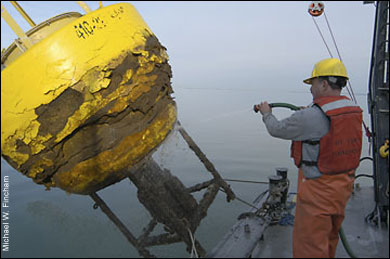
The last job for this cruise of the Henlopen is to pull up a big, expensive, and badly damaged buoy that spent the winter locked in the ice out on the Choptank River.
For three years, it had been taking measurements on weather and water conditions and relaying real-time data back to the Horn Point Laboratory. Then in January, the buoy went dead.
As the Henlopen glides up to the floating yellow tower on a gray morning in April, Boicourt can see why: The superstructure is banged up, the radio antenna is busted, and the solar panels are shattered. That's just the damage above the water line. This is what the ancient physics of ice can do to the latest technology for science.
The big buoy is one part of the Chesapeake Bay Observing System, a network of data-gathering buoys and land-relay stations that Boicourt first pioneered back in 1989. He began CBOS, as it's called, with two buoys, but in years when the funding was there Boicourt has had seven buoys out on the Bay simultaneously.
Every winter Boicourt has to face some tricky gambles with CBOS. Will the Bay ice up around his buoys? If so, which ones should he take out. "In the northern Bay, up near the Susquehanna River, the salinities are low, so it always freezes up there," says Boicourt. "We always take that out." But he gambles a lot with the mid-Bay buoy and usually wins. The Choptank River was supposed to be a safe bet.
For the buoy pickup, the entire Henlopen crew minus the cook turns out in hard hats and life vests. Hoisting a two-ton tower on board a crowded deck is awkward, even dangerous work, with an engineer running the crane and everybody else pushing with poles or pulling with ropes, trying to keep the fat-bottomed buoy from smashing the boat or the crew.
As they slowly swing the buoy on deck, Boicourt can see the rest of the bad news. The ice field cut ugly brown gashes in the yellow foam protecting the hull. It knocked the tower on its side, breaking all the weather sensors, pulling the data cable out and opening a hole in the side. After the ice damage, waves kept slapping through the hole, slowly flooding the electronics package buried in the hull. "We lost at least $30 to $40 thousand dollars worth of gear here," he says, pointing to the water now draining out of the hull.
It's one of the costs of doing science at sea, according to Boicourt. Oceanographers have been losing meters and buoys to the Bay ever since Don Pritchard started work in 1949. Systems like CBOS and ScanFish represent elegant technical advances in data gathering, but they still fall victim to 10-cent screws that disappear into the Deep Trench, lightning strikes that knock out telemetry towers and winter weather that ices over the Chesapeake.
Along with the mishaps have come the payoffs: better forecasts for shipping on the Bay and deeper insights in to the physics of the system. But these kinds of systems - and these kinds of payoffs - are only built through years of trials and errors and ice damage. "We've had these disasters before," says Boicourt, "and we will again in the future."
The future may hold more trials for Boicourt, not only in the Bay, but back out on the Continental Shelf where he began his research career. Since the physics of the Bay's circulation is driven, in part, by the physics of ocean circulation, he hopes to plant one of his CBOS buoys outside the mouth of the Bay so he can track the condition of incoming ocean water.
That incoming Shelf water may, in turn, be driven by forces let loose hundreds of miles away. Consider the Gulf Stream, one of Boicourt's favorite examples. As it curves east of Canada, it can spin off an eddy of cold water 100 miles wide that starts cruising south through the deep water next to the Continental Shelf. "On the way down, it's banging against the Continental Shelf," says Boicourt, "injecting high-salt water and organisms into the Shelf waters, conditioning the whole water that the Chesapeake Bay talks to."
As those Shelf waters then surge in at the southern end of the Bay, they carry remnants of that eddy - temperature, salinity and density conditions that will drive the physics of the Bay system all the way to Baltimore and beyond. Half the water in the Bay is ocean water. Salty water off Annapolis is shaped, in part, by seawater off Nova Scotia.
If that eddy from up north sounds a lot like the butterfly effect from Chaos Theory, remember that it was a meteorologist, Edward Lorenz, who first stumbled upon Chaos Theory. A single butterfly flapping its wings produces a tiny change in the atmosphere. Months later, on the other side of an ocean, a hurricane that wasn't going to happen hits land. Or one that was going to happen never forms.
A weather buoy comes aboard after a bad winter in the Chesapeake Bay. Ice fields cut and battered the hull and caused flooding that destroyed the electronics package carried inside. Photograph by Michael W. Fincham.
Meteorologists try to overcome the anarchy of nature by bringing more weather stations on line and building more sophisticated mathematical models. Oceanographers, their first cousins, are trying the same tack. "We are all sitting there saying, why don't our models work?" says Boicourt. "Well, we have to include that long-range influence, and that is one of the reasons that we have to have large, nested observing systems."
That means more than an expanded CBOS. Wending its way through Congress is a proposal for a network linking a number of existing coastal observing systems along the Atlantic seaboard. Chesapeake Bay modelers would be working with data from the Gulf of Maine, from Cape Cod, Long Island Sound, the Jersey coast and some of the coastal states to the south. These systems would be nested, in turn, in an even more ambitious, and expensive, Global Ocean Observing System.
Boicourt thinks the investment will pay off. Billions of data points, faster computers, more agile mathematical models - what do they add up to? What would CBOS do with data on distant waters. "With advanced techniques and advanced computer power," says Boicourt, "we can now write numerical models that are very accurate and very resolved."
The up side of Chaos Theory is better (but not perfect) predictability and a better understanding of the Big Picture. Meteorologists can give pretty good 24-hour forecasts for the Bay weather, and they can connect them to forces like the North Atlantic Oscillation, El Niño in the Pacific or Global Warming around the planet.
Oceanographers think they can do the same thing for the underwater weather of the Chesapeake Bay. The eddy from up north would still come this way, but they would know when it's coming and what kind of water it's carrying. They could also work out forecasts about what happens when remnants of the eddy try to cross the Rappahannock Shoals and start cruising up the Deep Trench towards Baltimore. Numerical oceanographers, of course, would have to put all that data together in their mathematical models.
Walking around the work deck of the Henlopen, Boicourt, the boat-deck scientist, is already putting his banged-up buoy back together in his head. "We'll have to replace the hull. We'll sandblast all the metal parts, replace the electronics." he says." We'll need new solar panels." The tower, at least, is still usable. And the oceanographer is still optimistic. "We'll get it back in shape."
If the country is ready to place another bet on big science, Bill Boicourt will be ready to take his buoys back out on the ocean.
|
|
![[Maryland Sea Grant]](/GIFs/h_footer_mdsg.gif)