|
The Buoys That Never Sleep
Could a network of data-gathering buoys finally reveal the mysterious inner working of the Chesapeake Bay?
Daniel Pendick
One of the Chesapeake Bay Interpretive Buoy System (CBIBS) buoys grew top heavy with ice and snow and capsized off Annapolis Harbor. Photograph, NOAA Chesapeake Bay Office
ON A FREEZING FEBRUARY MORNING IN 1996, the phone rang in Carole Derry's office at the Horn Point Laboratory. "Hey, your buoy is in the Choptank River," the caller said. On the line was an officer on one of Maryland's icebreaking ships that was opening channels in the Chesapeake. He knew the buoy did not belong in the river. And so did Derry. She was the research assistant at the lab charged with maintaining a fleet of data-gathering buoys stationed along the mainstem of the Chesapeake Bay. "I said, no," Derry recalls. "I don't believe you."
But the officer on the Maryland Department of Natural Resources (DNR) ship was right: a winter storm had uprooted a one-ton scientific buoy moored off James Island and shoved it 22 miles north, with its mooring chains and anchors — a pair of cast-iron boxcar wheels — trailing behind like a giant watch bob.
Then Derry got another call: the buoy had made it as far upriver as Castle Haven Point. This was just a few miles from Derry's office at Horn Point Laboratory, part of the University of Maryland Center for Environmental Science (UMCES), where the buoy was outfitted. "So we went down to Castle Haven and it was right there," Derry says. "That was the buoy that was coming home to me."
The bright-yellow buoy, 18 feet tall from its base to the top of its instrumented metal mast, had stopped transmitting data to shore on February 3rd. Slabs of winter ice, propelled by storm winds, had pulled the buoy free and dragged it north; then the wind shifted, blowing it eastward into the Choptank River. The DNR boat eventually snagged the buoy, craned it aboard, and ferried it into Cambridge Creek near the lab. Derry greeted the banged-up traveler at the dock. "I went down to see it and said, 'That's my buoy!'"
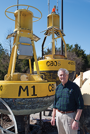
Bill Boicourt's old buoy network was called the Chesapeake Bay Observing System (CBOS for short), and it measured and monitored weather and water conditions in Maryland's half of the Bay. Today, ten buoys in the newer Chesapeake Bay Interpretive Buoy System (CBIBS) probe the length of the estuary. Photograph, Daniel Pendick
It was actually Bill Boicourt's buoy. He was Carole Derry's boss and a physical oceanographer who strung a network of scientific buoys down the mainstem of the Chesapeake Bay. This pioneering effort came to be known as the Chesapeake Bay Observing System (CBOS).
Boicourt came into oceanography as a protege of Don Pritchard, the distinguished scientist who founded the Chesapeake Bay Institute at John Hopkins University and then made the measurements and worked out the mathematics that documented the basic two-layer flow of the estuary — along the bottom, an incoming surge of dense, salty water from the ocean; along the surface, an outgoing stream of fresh water from all the Bay's rivers.
With his training, Boicourt was uniquely qualified to build a network of scientific buoys in the Chesapeake Bay. While still a graduate student, he had led expeditions to study large-scale circulation patterns in the continental shelf waters beyond the mouth of the Bay. To do that, Boicourt deployed scientific buoys for collecting long-term records of ocean temperature, salinity, and currents. These records led to new insights into the physical structures and processes in those offshore waters — including the Chesapeake Bay plume, the vast tongue of estuarine water that extends far out to sea from the mouth of the Bay. CBOS would allow Boicourt to use the methods he refined on the continental shelf to probe the rhythms and processes of the Chesapeake.
In two decades with CBOS, Boicourt's team fielded as many as seven different buoys. They kept tabs 24 hours a day on winds, temperature, humidity, currents, salinity, dissolved oxygen, and other essential information about the Bay and transmitted the data live on the internet.
That wild winter ride up the Choptank was just one in a long series of challenges that Boicourt faced in keeping CBOS alive and collecting data. Other showstoppers included buoys being struck by boats, burned-out light bulbs, dead batteries, and instruments gummed up by seaweed and barnacles. But along the way, the network would generate reams of valuable data that advanced Boicourt's research — particularly his understanding of estuarine circulation — and teach valuable lessons about how to build coastal and ocean observing systems that last.
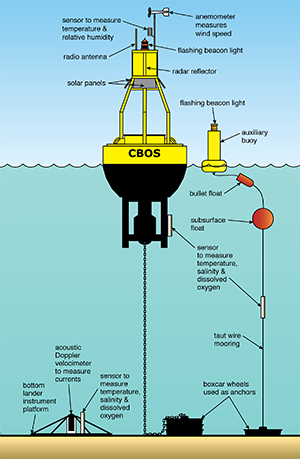
A typical CBOS observing station consisted of two moorings: one for the main buoy, which contained a computer and radio gear to transmit data to shore, and a smaller, auxiliary buoy to hold additional instruments. Stations collected continuous data on weather and water conditions and beamed them back to shore. A bottom lander platform supplemented the moorings, collecting data that needed to be retrieved later by hoisting the triangular rig to the surface. Illustration adapted by Sandy Rodgers from a drawing by Carole Derry and Bill Boicourt
CBOS Comes to North Bay
On December 18, 1990, Boicourt stood in a parking lot by the docks at Millard Tydings Memorial Park in Havre de Grace, Maryland, clutching the end of a long red ribbon and smiling for the camera. VIPs and guests stood along the length of the ribbon, stretched taut for cutting by the ceremonial scissors.
Behind them stood the first buoy in the CBOS network, gleaming with its fresh coat of yellow paint. Dubbed the North Bay buoy, it had a disc-shaped hull that housed advanced radio telemetry equipment. The top of its tall mast sported a suite of meteorological instruments.
Boicourt was getting his chance to take long-term data gathering in the Chesapeake Bay to a new level — thanks to Cathy Riley, a state senator from Harford County at the north end of the Bay. She had secured an appropriation to build the Northern Chesapeake Bay Research and Monitoring Facility at Tydings Park. This modest one-story building and its 50-foot radio mast would receive hourly bursts of data from the North Bay buoy — as soon as the spring thaw allowed Boicourt to moor the scientific sentinel into the Bay.
The small building in Tydings Park housed considerable hope — that this would be the start of a new kind of observation system for Bay science. Boicourt and several other scientists at UMCES hoped to build a network of six permanent buoy observation stations down the axis of the estuary, from the mouth of the Susquehanna River in the north to the mouth of the estuary in the south. It had never been done, but the scientists thought it was time.
By then, the state of the art in estuary observing was the Chesapeake Bay Program run by the Environmental Protection Agency. This state-federal partnership was taking monthly measurements down the length of the estuary, primarily from ships. But that left gaps in which short-term events, like storms, could alter the Chesapeake ecosystem undetected. The architects of CBOS argued that the buoys could fill those gaps by continuously monitoring the Bay from permanent observing stations with buoys that would provide stable moorings for a variety of scientific instruments at the surface, at mid-water, and on the bottom.
Boicourt hoped that CBOS would answer important scientific questions about the Chesapeake Bay, like how winds influenced the workings of the estuary in different ways. Research by Boicourt and others suggested that winds blowing across the surface could perturb its two-layer flow. Depending on direction, winds can speed up or slow down those outgoing and incoming flows. Summer winds can let low-oxygen water slip out of the deeps and into the shallows. Autumn winds can help oxygen-rich surface waters mix with deeper waters. In fact, strong winds appeared to stir up the Chesapeake so much that the two-layer flow temporarily disappeared. But how, when, and why were winds driving these changes? What were the physics?
The veteran oceanographer in Boicourt knew that to answer such questions, Bay scientists needed long, continuous records like the ones he had painstakingly pieced together with buoys on the continental shelf. To start to see patterns and understand the underlying processes, you had to be there when it happened. You needed a buoy out there, waiting, watching, measuring.
Keeping CBOS Alive
The North Bay buoy was tethered to its mooring in the spring of 1991 off Howell Point, at the mouth of the Sassafras River. Then it started beaming data across ten miles of open water to the Tydings Park receiving station. A second buoy started taking data in 1993, at the Mid Bay observing station in the waters off the Calvert Cliffs nuclear power plant.
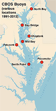
The North Bay and Mid Bay buoys remained in continuous service for more than two decades. Five other buoys went in and out of the water, some for only a season or two. Their moorings were positioned at various locations: at the Bay Bridge (known as Baltimore Approach in the CBOS network); at the mouth of the Choptank River; upriver in the Patuxent and Pocomoke Rivers; and as far south as Smith Point, at the Virginia border (see map). CBOS never expanded as far south as the estuary mouth, as originally envisioned.
Once CBOS was open for business, the hardest work lay ahead: keeping it running. The project hit some practical challenges that buoys of all kinds still face in the Chesapeake. Carole Derry, who worked as a senior faculty research assistant for Bill Boicourt until her retirement in May 2016, kept a binder of photos documenting the numerous insults visited upon CBOS buoys by man and nature — like being run over by boats or cracked open by winter ice.
Derry also built up a stack of handwritten maintenance logs in composition notebooks that documented the constant attention that CBOS demanded. The North Bay buoy, in particular, needed to be taken out of the water every winter to avoid ice damage. In general, the buoys needed personal tending every four to six weeks, whether to change instruments or batteries or make repairs.
Putting large buoys in the water or taking them out required large boats with rigging that could handle buoys weighing a ton or more as well as moorings with anchors and chain weighing up to one-and-a-half tons. Such trips were difficult to schedule and expensive. Boicourt sometimes had to depend on Coast Guard buoy vessels — when they weren't too busy tending to their own buoys.
As for Boicourt, his perpetual struggle was finding the money to pay for operating and expanding CBOS. It could cost $50,000 or more per year to equip and operate a CBOS observing station. The original funding for the North Bay station and shore facility ran out, but Boicourt still had buoys to tend and salaries to pay.
He had to piggyback much of the cost of purchasing, outfitting, and maintaining CBOS buoys onto his research projects. If a project involved collecting data with a buoy, CBOS could draw on that — until the funds ran out. Then Boicourt and his team had to secure new funding for Chesapeake science that could make use of the CBOS buoys.
Carole Derry holds a stack of handwritten maintenance logs that detail scores of repairs, upgrades, and deployments of the CBOS buoys (locations shown in map at right). The senior faculty research assistant, now retired, was on call to fulfill requests for CBOS data, go out on frequent boat trips to tend the buoys, and manage the reams of scientific data streaming from the CBOS observing network. Photograph, Daniel Pendick; map, created by Sandy Rodgers on a base map from Vectorstock.com
CBOS Data for Science
Through all the day-to-day challenges of keeping CBOS running, the buoys collected reams of data on meteorological and water conditions and beamed it back to shore. In the mid-90s, the data went live on the internet at www.CBOS.org. The science-curious general public — Boicourt calls them the "AOLers" — and recreational boaters often accessed CBOS's real-time data on wind, temperature, and humidity. Boicourt also discovered to his surprise that some professionals on the Chesapeake were visiting the site regularly. But the web addresses ended in ".mil," not "aol.com."
That's .mil as in military. Weather forecasters at the Patuxent River naval air station were tapping CBOS data on meteorological conditions over the estuary. So were computer modelers at the Army's Aberdeen Proving Ground, just across the water from the North Bay CBOS station. The Army tests weapons and ammunition at Aberdeen, and the modelers used CBOS data to improve their predictions of how far the concussions from the weapons explosions would travel and how strong they would be. "They had the fear of blowing out stained glass windows in churches on the Eastern Shore," Boicourt says.
Of course, he and his students were also using CBOS data. In September 2003, as Hurricane Isabel passed through the Chesapeake region, the Mid Bay buoy got a chance to demonstrate the scientific value of having a real-time monitoring system in the Bay.
The buoy's current meters, at depths of eight feet and 33 feet, recorded the strong water motions generated as the storm's winds rocked the entire contents of the estuary northward; then, as the winds died down, the Bay sloshed back southward.
A beat-up buoy from the CBOS network lies on its side in open-air storage at the edge of a parking lot at the Horn Point Laboratory. During a winter storm in 1996, fierce winds dragged this buoy and its mooring miles up the Choptank River. Despite the dings in its foam outer shell, the buoy continued to serve Bay science for many years. Photograph, Daniel Pendick
The storm furiously mixed the estuary, too, which temporarily erased its normal two-layer structure. Boicourt's buoy caught the process in the act, because the current meter down at 33 feet also included an instrument that measured the amount of oxygen dissolved in the water. This device, installed just a month earlier, sat within the Bay's low-oxygen or "hypoxic" layer. Deeper, at 62 feet, a salinity sensor was also testing the waters.
As the hurricane winds mixed the Chesapeake up, the sensors caught the rise in oxygen and the fall in salinity as the fresh upper layer and saltier lower layer swirled together. This "destratification" of the Bay is exactly the type of thing that Boicourt hoped CBOS would see. Such real-time monitoring, coupled with later computer modeling studies, can confirm hypotheses and generate new questions — in this case, about "wind forcing" of the Bay system and the effect that has on oxygen conditions.
Ironically, by the time of CBOS's shining moment during Isabel, the constant scramble to piggyback the cost of running the buoys onto Boicourt's research funding had started to wear thin. One by one, the observing stations in the Chesapeake were shut down. "We were reduced from seven to about three and then finally two," Boicourt says.
In 2004, only the North Bay and Mid Bay observing stations were still taking data. North Bay went dark in 2005. The Mid Bay station struggled along until 2010. "In 2010, it started having problems," Carole Derry says. It recorded no data in 2011. Derry says she is pretty sure it was struck in 2012 by a boater. "It was decapitated."
That may have been the end of Bill's real-time buoy network, but the dream of building a real-time scientific observing system for the Chesapeake Bay lives on. By the time the last CBOS buoy stopped transmitting data, the National Oceanic and Atmospheric Administration (NOAA) was completing a new network of scientific sentinels: the Chesapeake Bay Interpretative Buoy System (CBIBS).
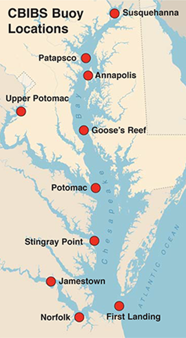
The intended purpose of CBIBS seems right out of the playbook of early CBOS. The new system provides real-time information about weather and water conditions for scientists and citizens. The buoys stretch the full length of the Bay, from the Susquehanna River to the mouth of the estuary. Buoys sit at the mouths of major rivers as well as at stations far upriver — from Jamestown in Virginia, to the National Harbor in Maryland.
The CBIBS network initially obtained funding as part of the Captain John Smith Chesapeake National Historic Trail, with buoys marking key spots in the estuary that Captain John Smith visited from 1607 to 1609. The first three buoys went in the water in 2007 — one at historic Jamestown — to mark 400 years since Smith's arrival in the Chesapeake region. A boater or kayaker can call the historic markers by cell phone and hear the historic background for each location.
NOAA is working to make CBIBS buoy data useful and available to as many researchers as possible. Making that happen is Byron Kilbourne's new assignment. The recently minted Ph.D. oceanographer from the University of Washington in Seattle joined the small CBIBS team in Annapolis in January 2016. Kilbourne is charged with keeping CBIBS fully functional, reaching out to potential users in the science community and making sure the data comply with quality standards. Kilbourne hopes to also use CBIBS information to do some original research of his own.
Thanks in part to Boicourt's buoys, CBIBS has an opportunity to fulfill the dream of a real-time observing system for the Chesapeake Bay. CBOS showed what such a system could look like. "We learned a great deal about what it takes to deploy an observing system and what it takes to maintain an observing system," says Thomas Miller, director of the UMCES Chesapeake Biological Laboratory. "I think it was a visionary exercise, well ahead of its time, and in no way did it fail. It was just not sustainable."
That lesson — that observing systems are expensive and hard to maintain over the long haul — is a key lesson of the CBOS saga, Boicourt says. CBOS never lacked for what he calls "cheerleaders" like the AOLers and the computer modelers at Aberdeen Proving Ground. But that did not translate into a sustained annual budget — like the one CBIBS draws on.
"We learned the hard lesson of what sustainable systems required," Boicourt says. "They require you to not just collect data and make it available, but package it for specific users in a way that will get them to either pay for or support the collection of it."
Although CBOS.org's real-time data stream has ceased, the buoys themselves continue to serve Bay science. Several of the big old buoys — including the one that took that wild ride up the Choptank in 1996 — stand at the edge of a parking lot at Horn Point Lab, where they greet Boicourt as he comes to work every day. They sit amidst a jumble of spherical steel floats, metal platforms for holding instruments on the Bay bottom, cast-iron boxcar wheels, and rusting piles of mooring chains.
Boicourt has continued to deploy the buoys for research or loan them to other investigators. Though battered and bruised, several of the buoys were bobbing in the Chesapeake as recently as 2013, part of a flotilla of 20 buoys that studied the physical processes that link winds to changes in the large-scale circulation and mixing of the estuary.
Boicourt says this recent multi-investigator project was the culmination of all the previous years of work with CBOS observing the effects of wind on the Bay. The study benefitted from the latest technology — like special sonars that look upward from the estuary's floor to measure currents at multiple levels. One of the studies that came out of the observing project, led by Woods Hole scientist Malcolm Scully, offers new insights into the details of how winds mix the Chesapeake. Wind-driven breaking waves create spiral flows in the air above the Bay, called Langmuir turbulence, which pumps energy deep below the surface and mixes the upper and lower layers like an eggbeater.
CBOS was put in the Bay in hopes of gaining these kinds of physical insights. Although Boicourt is happy to tell you how hard it was to keep CBOS afloat all those years, his efforts did bear fruit. "You could argue that the time would have been better spent otherwise, but we got a chance to do some good science," he says. "We have learned a lot from looking at that old CBOS data — and I still look at it. We know now that what happens from one month to another, like storms and wind, is important."
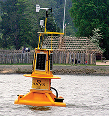
The Chesapeake Bay Interpretive Buoy System (CBIBS) (at left) collects water and weather data at the mouths of major rivers and farther up river, too. Keeping the ten buoys up and running is challenging, and CBIBS's lead buoy repairwoman, Katie Kirk (below, bottom), makes frequent trips to service the buoys. This buoy (below, top), located off Jamestown, Virginia, is part of the Captain John Smith Chesapeake National Historic Trail. Photographs, Courtesy Chesapeake Bay Program (below, bottom) and NOAA Chesapeake Bay Office (below, top); map, created by Sandy Rodgers on a base map from Vectorstock.com
|