|
An Imprint of an Impact
Jessica Smits
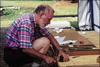
When core samples in southeastern Virginia back in 1986 showed some surprising results, Wylie Poag was one of three micro-paleontologists called in to investigate. Shown here as he prepared a portion of the core for study, he would later analyze the fossilized microorganisms hidden within the sediment. Because microfossils have been well studied, they help scientists date layers of sediment. In this case, Poag and his colleagues discovered that microfossils of different eras were jumbled and mixed together — the result of a powerful impact. Their research led to the discovery of the enormous Chesapeake Bay meteoroid crater (above). Photograph and drawing, U.S. Geological Survey.
IT CAME FROM OUTER SPACE. A massive meteoroid, at least 2 miles wide, hurtled toward Earth at 60,000 miles per hour. Upon impact it extinguished life within several hundred miles. Its force: 100 times greater than the entire nuclear arsenal of the world. Tsunami waves crashed on land. Clouds of pulverized debris blocked the sun. Then, acid rain poured. Be thankful you didn't call the Chesapeake home 35 million years ago.
For hundreds of years people sailed the Bay, studied the Bay, without knowing the story hiding beneath it. There were clues along the way. Oddities that befuddled researchers. Things that just didn't make sense. It took a scientist from Woods Hole on Cape Cod to piece together the mystery and discover the proof: a 50-mile-wide crater buried one mile beneath the Chesapeake and southeastern Virginia. An imprint of an impact that, he says, still affects us today.
C. Wylie Poag calls himself a lithobioseismostratigrapher. It even says so on his business card. After reviewing some Latin and Greek roots, you'll find Poag figures out the geologic history of an area. But Poag, now an emeritus scientist for the United States Geological Survey (USGS), could add a simpler title to his card — sleuth.
In 1983, he was serving as co-chief scientist onboard a drill ship off the coast of New Jersey when the team made an intriguing discovery. One of their samples contained tektites (beads of silica glass), which are considered "unequivocal diagnostic evidence" that a meteoroid had once struck the East Coast of the United States. But where?
Three years later, the USGS and Virginia State Water Control Board drilled several cores to help them evaluate potential sources of fresh groundwater in southeastern Virginia. Cores give researchers a look at the layers of rock under the surface — their content, age, and attributes. Each layer serves as a sort of time capsule, offering a glimpse of the Earth at that time. But the recovered cores did not follow this layer cake recipe.
Wylie Poag was one of the scientists charged with analyzing the cores' puzzling contents. He writes that instead of neat layers with the youngest on top and the oldest on bottom, the sediments were "wildly disarranged." It was apparent to him that something powerful had mixed layers of geologic history into one single layer and dumped it over an area the size of Connecticut. Was southeastern Virginia the location of the East Coast meteoroid strike?
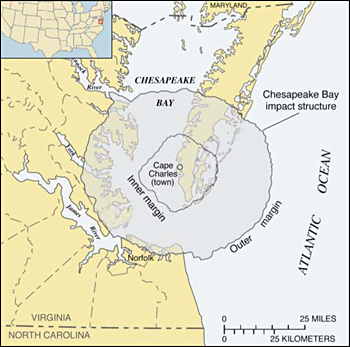
To answer that question, Poag turned to Texaco and Exxon in 1993. In their search for oil beneath the Chesapeake, the companies had collected seismic reflection profiles: two-dimensional line drawings of the Bay bottom. Once Poag laid eyes on the profiles he knew he had found what he was looking for. The drawings showed a huge hole beneath the Bay — a crater that spanned more than 50 miles and was almost as deep as the Grand Canyon. "Ground zero" was the spot where the town of Cape Charles now stands.
The oil companies had the data, but it never occurred to anyone that it was a massive impact crater, Poag says. "They were puzzled, but they weren't thinking that way." Because of what he'd seen in New Jersey and Virginia, Poag says, "I'd been thinking that way."
"Thinking that way" gave Poag the highlight of his career. News of the crater discovery attracted media attention from around the globe. "It was a heady time," he recalls.
But what does the presence of a 35-million-year-old crater mean today?
For one, it answered the question about some very salty water in southeastern Virginia, Poag says. The impact blast destroyed ground-water aquifers in a 200-square-mile area, creating a single reservoir filled with water 1.5 times saltier than seawater. This brine reservoir makes finding freshwater aquifers difficult. Hydrologists had known about the brine water but didn't understand its origin. Knowing the location of the crater now makes it possible to plot the distribution of the water and know where to find fresh water and where not to find it, Poag says.
Additionally, the watery sediment (breccia) that fills and surrounds the crater has implications for cities nearby. Heavier sediment piled on top can force compaction and subsidence of the land. Movement of the land along faults created by the blast puts some areas at risk during the unlikely event of a large earthquake. Land subsidence near the crater may also be partly to blame for the high rate of relative sea level rise in the lower Chesapeake.
Did this long-ago blast help form the shape of today's Chesapeake Bay? Poag thinks so. Gravity pulls rivers to the lowest elevation, he says, and the buried crater left "a template" that millions of years later let rivers like the Rappahannock, the York, and the James flow together to form the Bay's southern basin. Other geologists disagree. The crater, they claim, was buried long before the Bay ever formed and is no longer expressed in the topography.
Millions of years after it crashed in the earth, the meteoroid still generates some heat.
|