|
Bridge over Buried Rivers
Michael W. Fincham
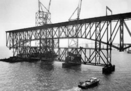
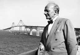
Standing on the newly built Chesapeake Bay Bridge in 1952 is former Governor William Preston Lane (right), who had pushed through funding for the bridge. Construction began in 1949, but a lot of preparation came first. To find the best locations for the bridge’s foundation, engineers drilled a series of boreholes. The coring logs, which included detailed descriptions of the color and texture of sediments at different levels, provided geologists with information valuable in mapping out the channels of ancient estuaries. Credits: Baltimore Sun Media Group (left, all rights reserved) and Collection of the Maryland State Archives (right).
IN 1938, A LINE OF TEST BOREHOLES WAS DRILLED across Chesapeake Bay between Sandy Point and Kent Island in hopes that a bridge (or possibly a tunnel) might finally be erected that could link the Maryland mainland and its Eastern Shore counties with something faster than steamboats and ferries.
A funny thing happened on the way to the Eastern Shore: geologists discovered evidence of an older Chesapeake buried beneath the Bay.
It would be a discovery slow in coming. Hopes for a Chesapeake Bay bridge or tunnel had been rising and falling for more than 30 years: committees and commissions had formed, tunnels and trolley car bridges had been proposed, other locations had been studied. No bridge was needed, according to The Baltimore Sun, because everybody would soon be flying their own planes. No bridge was wanted, according to Eastern Shore natives, because their way of life might be contaminated by too frequent contact with fellow citizens from the far shore.
No bridge was built. The samples and logs from the 1938 test borings went into dry storage for another decade.
In 1948, hope flared again when Governor William Preston Lane pushed through a funding plan, and the Raymond Concrete Pile Company then drilled 23 new test borings across the Bay. While none of the cores struck bedrock, they reached as deep as 257 feet below the water and found enough firm sand to support bridge pilings. The next year the J.E. Greiner Company began erecting the Chesapeake Bay Bridge, the largest public construction project in Maryland history, a four-mile steel structure with two twin towers that would reach as high as 354 feet above the water. On July 30, 1952, the bridge opened with speeches and sightseeing tours and a line of cars headed east. Life on the Eastern Shore, for better or worse, would never be the same.
All the samples and logs from the test borings for the bridge went back into storage, but not for long. Academic geologists, who usually can't afford to drill down hundreds of feet, began reviewing the engineering records of the Greiner company. What they found in the bridge logs kicked off the first search for the long-buried channels of earlier Chesapeake Bays.
The first scientist to retrieve the logs was J. Donald Ryan, a geologist just finishing his Ph.D. at Johns Hopkins University. Hired to organize the first Baywide analysis of the Bay's sediments, Ryan examined the logs and saw detailed descriptions of four layers of mud, silt, clay, sand, and gravel. The logs held clear evidence, he wrote, that below the Bay's valuable shipping channel lay two older channels. Writing in 1953, he claimed the larger and more deeply buried channel was "unquestionably an ancient river canyon."
Geology Below the Bay
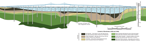
To find the best locations for the bridge's foundation, engineers drilled a series of boreholes. The coring logs, which included detailed descriptions of the color and texture of sediments at different levels, provided geologists with information valuable in mapping out the channels of ancient estuaries. This illustration shows an approximation of how the boreholes from 1938 and 1948 and the underground cross section of soil layers they revealed line up with the above-the-water bridge. The layer with small dots indicates sand and gravel — for geologists the sign of a riverbed. This deposit clearly outlines the sides and bottoms of buried river channels. The deepest channel runs well to the east of the center span of the bridge. Geologists believe it is the paleochannel of the Susquehanna River Valley as it was some 18,000 years ago. Named the Cape Charles Channel (see Three Ancient Estuaries), it runs all the way to the mouth of Chesapeake Bay. To the west of the deep channel is a shallower paleochannel beneath the center span of the bridge. This channel could be a tributary, perhaps the Patapsco River, which may have flowed through here on its way to hook up with the Susquehanna. Illustrations adapted from drawings in the Chesapeake Bay Bridge engineering report (J.E. Grainer 1948).
The coring logs next drew the attention of John T. Hack, a scientist with U.S. Geological Survey who would become a major figure in modern geology. Hack believed the Bay Bridge records revealed geological forces at work around the estuary. Two lower levels of sediment, he noted, held hard belts of sand mixed with gravel. According to Hack, the coarse gravel in these two layers marked them as riverbeds of ancient channels. "He was one of the pioneers," says Steve Colman, a geologist who later led a Baywide search for buried channels. "He showed very clearly there was more than one generation of filled-in river channels."
Trying to build a larger picture of the evolution of the estuary, Hack proceeded to collect coring logs from 14 bridge sites in all, including crossings of the Susquehanna, the Potomac, the Rappahannock, and the York. While geologists usually like to eyeball the color and texture of any rock or clay or gravel they analyze, Hack had to rely instead on the written descriptions in the logs left by bridge engineers and well drillers. By comparing core logs and well logs from sites around the estuary, Hack was able to argue as early as 1957 that all the major rivers around the Chesapeake held buried channels. More importantly it appeared they held multiple channels created by several cycles of falling and rising sea levels.
The new bridge over Chesapeake Bay would change the Eastern Shore, opening it to more vacationers, retirees, real estate developers, and big-box shopping malls. It also changed life for geologists, offering them a bridge back into the deep history of the Bay (see Channeling the Chesapeake). What they would find there, ironically enough, was unexpected evidence that the growth of the Eastern Shore has been changing the shape of Chesapeake Bay for nearly half a million years.
|