![[Chesapeake Quarterly masthead]](/images/uploads/siteimages/imported/masthead.gif)
|
|
|
2005
|
Volume 4, Number 2
|
Table of Contents
|
Subscribe
|
Download pdf
|
|
Book Review
The Bay's Vanishing Islands
By Jack Greer
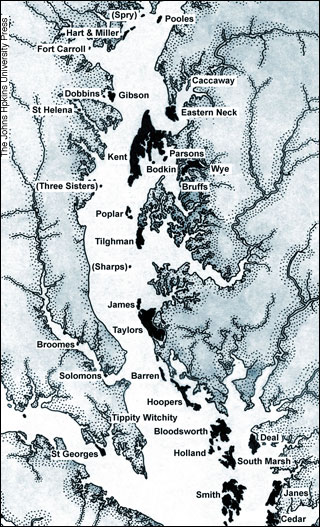
The Disappearing Islands of the Chesapeake by William B. Cronin. The Johns Hopkins University Press, 2005. Baltimore and London. 200 pp. The year is 1900. On Holland Island, off Maryland's Eastern Shore just north of Smith Island and just south of Bloods-worth Island, some 250 people live and work, mostly farming and fishing. Holland Island has its own post office, a school and a baseball diamond. Along with a postmistress, it boasts a doctor and a preacher. But already global forces are eating at the island, and rising Bay waters, driven by winds and storms, continue to dissolve the soft banks, day by day, month by month, year by year. The island is melting away, and by 1910 the preacher, the postmistress and the doctor are gone. Others leave with them, and in 1918 a summer gale drives the last family from their home on Holland Island. Every island tells a story, and now William Cronin, oceanographer and obvious island-lover, has compiled an anthology of those stories in a new book from Johns Hopkins University Press, The Disappearing Islands of the Chesapeake. Cronin's affection for the people and the places he describes draws on his personal experiences. For many years Cronin served as a staff oceanographer for the Johns Hopkins Chesapeake Bay Institute, and captained the research vessels Lydia Louise I and II. These cruises took him to many an island, and his twenty-five foot sailboat, Ginger, took him to many more. There he met and spoke with island residents and shared their memories, or wandered alone with the ospreys and herons, on islands where human denizens have long since disappeared-. And those forces have radically increased. Until 1900, Cronin writes, Bay waters rose at a rate of about Cronin makes clear that the process that formed the Bay when the glaciers began to melt 15,000 years ago "has never ceased." With some 8,100 miles of exposed island and mainland shoreline, he points out that the Bay is "perpetually vulnerable to forces of wind and water." And those forces have radically increased. Until 1900, Cronin writes, Bay waters rose at a rate of about three feet every 1,000 years, or about three and a half inches per century. During the past 100 years, the Bay rose twelve inches — a rate of one foot per century. More than a scientific treatise, Cronin's book is at its heart a tour — or a cruise. His trip through time includes rumrunners, Revolutionary War patriots, and tea-bearing brigs. Cronin tells the colorful story of the Three Sister Islands that lay off the mouth of the West River, where the 130-ton brig Totness went aground in July 1775 with its cargo of tea. After allowing the crew to vacate the ship, local rebels burned it to the waterline. The Three Sister Islands, though for years plowed and planted by farmers, gradually melted away in the Bay's rising waters, and by the 1850s they finally vanished altogether. Anyone sailing out of the West River now will see only endless waves, and a shallow sandbar on the chart. A similar fate befell Sharps Island, at the mouth of the Choptank River, which Cronin says was first recorded at 449 acres. Owners came and went during the 1600s, 1700s, 1800s. The island saw farms and livestock and houses, and finally at the end of the nineteenth century a hotel and a long pier for visiting steamboats. By 1900 the island had shrunk to 94 acres, and then continued to crumble — at a remarkable rate of 110 feet a year, according to Cronin. By 1963 it was gone for good. Not every island has eroded away, of course, but while Cronin provides endearing- descriptions of the islands that are still with us, somehow it is the ones that have vanished that touch us most. They capture in a remarkable way the inexorable toll of time. The Disappearing Islands of the Chesapeake is a book well worth owning for anyone interested in the geography, history and lore of the Bay. Alongside its informative text the book contains numerous maps and charts, and its pages are further graced with the photographs of A. Aubrey Bodine (1906-1970), whose love affair with the Bay is described in an introductory note by Thomas Moore, Curator of Photography at the Mariners' Museum. |
|
|
Top of Page |
|
|
Home |
Contents |
Other Issues |
|
|
|
||||
![[Maryland Sea Grant]](/images/uploads/siteimages/imported/h_footer_mdsg.gif) ![[NOAA]](/images/uploads/siteimages/imported/h_footer_noaa.gif) |
This page was last modified July 07, 2006 |