![[Chesapeake Quarterly masthead]](/images/uploads/siteimages/imported/masthead.gif)
|
|
|
2004
|
Volume 3, Number 1
|
Table of Contents
|
Subscribe
|
Download pdf
|
|
|
||
|
The Hydraulics of a Hot Spot
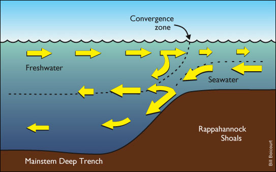
By Michael W. Fincham Why is the Bay so productive? A new hypothesis about the physics of underwater systems may help answer this question. The Hydraulic Control Point is a kind of sluice gate in the middle of the Bay that regulates the flow of incoming ocean water. Its discovery came as a surprise, especially for Bill Boicourt, and illustrates the interplay between two kinds of oceanographers: ocean (or Bay) observers and mathematical modelers. As a physical oceanographer, Boicourt is primarily an observationalist, specializing in testing and developing data-gathering equipment and working out techniques for deploying them out on the water. He knew there were structural features like Hydraulic Control Points in the fjords of Norway where glacial moraines form high sills, separating seawater from fresh water. He also knew nobody had ever found one in the middle of a partially mixed estuary like the Chesapeake. This new discovery began with the work of Shenn-Yu Chao, a numerical oceanographer who tests and develops mathematical models, working with the kind of data that Boicourt and other field workers have collected over the years. While developing a general model of hydraulic controls in estuaries, Chao looked at old data left over from Tropical Storm Agnes, a major flood event that hit the Bay in 1972. In the old data he saw a rapid decline in saltwater coming up the Bay during and after the runoff flooding. He suggested a Hydraulic Control was active in the Chesapeake. The location, according to his analysis, should be right at the juncture where the Deep Trench meets the Rappahannock Shoals. The Trench is the old paleochannel that runs straight down the mainstem, stopping abruptly at the Shoals, a wide band of built-up bottom south of the Potomac River. This coupling of a ridge with a drop-off creates a sill similar to those in the fjords of Norway. Chao works down the hall from Boicourt at the Horn Point Laboratory of the University of Maryland Center for Environmental Science, but that didn't make it any easier for a boat-deck researcher like Boicourt to believe a numerical modeler. "This is embarrassing. I sure didn't see it," he admits. But the ScanFish did, sucking up data points by the billions on a series of tows that crisscrossed the Shoals and Trench in 1999 and 2000. "Lucky we had the ScanFish," he says, "because you need the resolution there to pick this up." If he had made a bet about these findings, Boicourt would have lost - and lost big. "It turns out," he says, "the Hydraulic Control is much more important than even he (Chao) thought." Here's roughly how the Hydraulic Control works. Incoming ocean water, dense and cold and salty, surges slowly north along the bottom of the Bay while outgoing river water, light and warm and fresh, slides south along the surface. Separating them is a boundary called the pycnocline. Ocean and river water both move with a net average speed of around six miles a day. Twice daily their progress speeds up and slows down with the tidal cycle. That's the steady-state model of estuarine circulation, according to the physicists, but steady states never last for long on the Bay. At the Shoals, these two streams suddenly have to squeeze through a narrow slot or sluice gate. Under unsteady states - say heavy winds or river runoffs - all kinds of collisions occur. And the physics gets complicated. Consider scenarios like spring runoff, wind storms or tropical storms: Strong flows of outgoing river water rush down the mainstem, overwhelming ocean water at the Shoals and pushing down on the pycnocline. The result is like turning a valve: ocean water is slowed to a trickle, robbing the upper Bay of saltwater and zooplankton, fish larvae and oxygen. The valve can be turned on, often fairly suddenly. Wind patterns will blow surface water away from the sill, lifting the pycnocline, releasing all that backed-up bottom water, unleashing unseen waterfalls well below the surface of the Bay. Ocean water will come flooding over the sill and down into the Deep Trench. A batch of high salinity water will ferry plankton and fish larvae and oxygen into the upper Bay. "You'll sometimes get two weeks of strong pulsing flow," says Boicourt. "And then it'll shut down again." Along the Hydraulic Control, physics amplifies biology. Water masses are driving against each other, creating density fronts and downwellings that collect nutrients and plankton and fish larvae. These convergence zones can become biological "hot spots." Hot spots like this are now the cornerstone for a new hypothesis about the persistent productivity of the Chesapeake Bay. The research question: Why such an abundance? "You get more fish than you would predict, given the amount of plant production," explains Mike Roman, a zooplankton ecologist and Director of the Horn Point Laboratory. The proposed explanation: Because the physics of the system creates so many front-like features that collect algae and plankton and fish larvae, setting up "chow lines" for foraging fish at key sites around the Bay. These chow lines, says Roman, are sometimes visible. A foam line marks the boundary where water masses collide. Fish come schooling in to feed on plankton. Birds come wheeling over to dive on the fish. Fishermen in boats arrive soon after. Scientists have also been accumulating along these hot spots. Oceanographers and biologists and plankton ecologists teamed up for numerous sampling runs as part of a long-term study called TIES, their acronym for Trophic Interactions in Estuarine Systems. With funding from the National Science Foundation, scientists at the Horn Point Laboratory worked together with colleagues from the Chesapeake Biological Laboratory, the University of Delaware, Old Dominion University and NOAA's Great Lakes Environmental Research Laboratory. On two dozen cruises, they crisscrossed these chow lines in a sampling frenzy, deploying a number of new tools like the ScanFish as well as old tools like plankton nets and fish trawls. All this fieldwork dredged up abundant data about all levels of the food web - and provocative evidence for the productivity hypothesis. "In one trip with the ScanFish, I collected more data than I had in 20 years," says Roman, and when he looked at it a clear pattern leaped out. "We analyzed six years of data," he says, "and some areas light up every single time. There are regular [hot] spots of higher zooplankton - and the fish have evolved to swim and find them out." Now that science has evolved to find these hot spots, the productivity of the Bay is turning out to be quite "patchy." Twenty percent of the Bay's waters, Roman estimates, may hold 36 percent of the zooplankton. Where are these hot patches? North of the Chesapeake Bay Bridge - way north in a dry year - is the Estuarine Turbidity Maximum, a mixing zone where the front of the salt wedge meets freshwater river flow from the Susquehanna. Wherever a major river empties into the mainstem, rich river plumes are formed. Below Smith Point, south of the Potomac, is the on-again, off-again Hydraulic Control Point. Down near the mouth of the Bay, is the Cyclonic Eddy, just inside the southern end of the Eastern Shore peninsula. You can't find these patches on boating charts of the Bay, not yet. They are not as striking or evocative as the Bay's famous bridges and lighthouses and coves and creeks. But they are starting to show up on most research maps, famous now as the key places where the Bay's unique physics drives its bountiful biology.
|
|
|
Top of Page |
|
|
Home |
Contents |
Other Issues |
|
|
|
||||
![[Maryland Sea Grant]](/images/uploads/siteimages/imported/h_footer_mdsg.gif) ![[NOAA]](/images/uploads/siteimages/imported/h_footer_noaa.gif) |
This page was last modified June 07, 2004 |