on the Bay
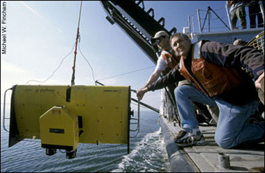
Photograph: Boicourt and research assistant Tom Wazniak lower a ScanFish into the water where it will undulate through the Bay, measuring temperature, salinity, dissolved oxygen, chlorophyll and plannkton. By Michael W. Fincham.
Contents
|
|
|
|
|
This Issue's Videos:
New Tools for theOceanographer Finding Gold at the Bottom of the Bay |
By Michael W. Fincham
There is a weather under the Bay, it seems, and it features some of the same events we watch on the evening newscast, including storms, cyclones, high-pressure systems, low-pressure systems and fronts of all kinds.
It will be nearly midnight when they finally throw the ScanFish off the boat.
Standing on the stern of a research vessel as it pulls slowly out to sea, Bill Boicourt can see a string of lights receding behind him. They mark the bridges that stretch like bright ropes laid across the southern gateway into the Chesapeake Bay. The oceanographer is back out on the ocean again, at least for a little while.
Tall, athletic and highly verbal, Boicourt has some salt in his hair and thirty years of research trips on his resume. He's out on the back deck, the working end of the R.V. Cape Henlopen, getting ready to launch his favorite research tool - a sleek yellow wing, chopped bluntly at the outer tips and called, logically enough, a ScanFish. It's a high-tech metal and fiberglass fish, crammed with sensing gear, but this fish can't swim on its own. Boicourt's plan is to drop the ScanFish out here in the ocean, then tow it back into the estuary and haul it northwards for nearly 200 miles, all the way up through the heart of the Chesapeake.
But for now the Henlopen is in a holding pattern, waiting for an incoming ship to clear through one of two deep-water channels, the main runways that big ships use on their approach into the Chesapeake. Operated by the University of Delaware, the Henlopen is 120 feet long, a good size for a coastal research vessel, but a small fish in these waters.
Up on the darkened bridge Captain Jimmy Warrington is using radar and binoculars to track everything that's moving out on this coastal crossroads. Off to the south, he can see a huge warship riding at anchor, its black mass blotting out the shoreline beyond. Out to the east where the blackness stretches towards Europe, all he can see of the incoming ship is a dim running light. It could be a tanker, bulk carrier or container ship, but at this distance, its light is barely visible and barely moving. Since it's early April, Warrington also has to watch out for North Atlantic right whales, big fish that sometimes cruise these waters.
Out here along the Continental Shelf is where Boicourt did his thesis work as a graduate student, but he's spent much of his career working the inside waters of the Chesapeake Bay. He's a physical oceanographer, a species of oceanographer that focuses on water masses and their motions.
It's a branch of science that's closer to physics than to marine biology or ecology, but its closest cousin is meteorology. "We are sort of the meteorologists of the ocean," says Boicourt, now a professor at the Horn Point Laboratory of the University of the Maryland Center for Environmental Science (UMCES). "We are trained a lot of times in the same institutions by the same professors as meteorologists. We're both dealing with fluids on large scales, what we call geophysical scales." Meteorologists deal with the fluids of air, oceanographers with the fluids of water. "There are differences: water is heavier than air," he says, "but the basic math and the ways we go about looking at things are remarkably similar."
There is a weather under the ocean and the Bay, it seems, and it features some of the same events we watch on the evening newscast, including storms, cyclones, high-pressure systems, low pressure systems, and fronts of all kinds, some of them stationary, some mobile, some quite ephemeral. In the Bay there are also two slow-moving jet streams: river water heading south and seawater moving north. Just like weather fronts in the sky, these masses of water create structures and forces in the Bay. They're not as easy to see as clouds or rain or wind, but they affect nearly every life form found in the estuary.
As the incoming ship clears through, Boicourt and the deck crew go to work. A crew member operates the port-side A-frame, hoisting the ScanFish off the deck. Grabbing the lift rope, Boicourt strains backward to keep the device from swinging too fast out over the side. At 300 pounds, the ScanFish is an easy lift for the A-frame, but if it swings out too fast, it can pendulum back, smashing an oceanographer.
The ScanFish plunks lightly on the water, then floats quietly - too quietly. "We need to speed it up a little bit," Boicourt calls out. "It's caught at the surface." The ship's technician keeps working the winch controls, paying out cable. As the boat picks up speed, the ScanFish burbles along, then starts a slow dive into dark water.
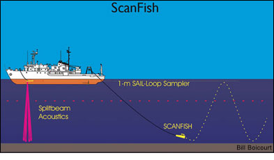
The ScanFish will be dragged through the Bay for the next 30 hours, zigzagging up and down, its sensors hauling in an ocean of data, over 90,000 data points an hour on salinity, dissolved oxygen, chlorophyll and plankton. It's just one of the sophisticated - and expensive - instruments that Boicourt and his research team have introduced into estuarine oceanography.
In 1989 they created the Chesapeake Bay Observing System (CBOS), a network of two to seven buoys that can constantly measure and instantly communicate data about a suite of water and weather conditions. For those who study the physics of water masses, the sensors in the ScanFish and in the moored buoys in the Observing System have created a quantum leap in high-resolution data gathering.
But it's an expensive leap. A ScanFish, fully outfitted, costs about $200,000. A research vessel to tow it goes for $7,000 a day. A single CBOS buoy, with all its sensors and electronics, can carry a price tag of $100,000. In terms of dollars per data point, these devices are a bargain, and they add up to small change compared to the costs of deep-ocean technology. But in the tidal waters of estuarine research, this is big dollar science.
Will there be a payoff from these huge streams of data that oceanographers are now hauling in? This is the bet riding on that high-cost technology that Boicourt just offloaded into the midnight waters of the Continental Shelf.
Up on the ship's bridge, the crew has already changed shifts. The captain has been relieved by Mike Popovich, the young first mate who gets "the dog watch" from 11:30 until 5:30 a.m. when the galley opens for breakfast. Down in the science lab, Boicourt checks the computers monitoring the ScanFish, then clambers back to his bunk down on the third level. When he wakes up for his own 4 a.m. watch, the oceanographer will be back in the Chesapeake Bay.
One of a new generation of data-gathering tools, ScanFish enables scientists to collect large amounts of information in a fraction of the time. Before this new technology a typical Bay transect would take one hour and provide about 30 measurements. The ScanFish, in an undulating transect, can provide measurements of multiple factors every two feet, up to 90,000 an hour. By Bill Boycourt.
![[Maryland Sea Grant]](/GIFs/h_footer_mdsg.gif)